Mill Creek (New River tributary)
2 - Ansted to the confluence of the New River
July 15, 2004
| Reporter | John Petretich |
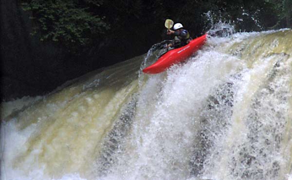
Mill Creek Falls is a little more than 20' high. When running the falls, stay to the center of the channel. Run it too far left and you will land on bedrock just under the surface of the water.
This photo depicts the top of this rapid well. Water pushes hard into the large river left boulder at the top as it gushes through the narrow channel. Most paddlers run the bottom of this rapid on the far right.
You'll come to the horizon line for this rapid just after passing the sewage plant on the right. It can be scouted from the right bank. In this 9-10' falls, the majority of the flow (and deepest channel) are along the right bank where the water spills off the ledge landing on rocks. In a perfect line, paddlers drive left out of this flow, drop off the ledge and slide down the face of the large boulder. It is important not to go too far left though. You would fail to bridge the gap and drop into the sieve in front of the boulder!
This rapid is the first below Mill Creek Falls. Note the ledge that sticks way out from the left bank. The move here requires precision and timing but is one of the most enjoyable on the creek. You just miss (or sometimes grind off) the overhang as you drop into the slot and under it. One more thing of note: the left bank is undercut below the rapid (I am standing on it to take the photo).
This photo gives a good idea of what you are looking at when entering this rapid. The entirety of the creek's flow sluices through the narrow channel and pillows against the large left boulder.
After sluicing against the large left hand boulder in the entrance, the water gushes out into the rapid proper with intense force and speed. You'll note the ledge that Pete is paying particular attention to. You'll want to come off of it to the right and get out of the main flow of the rapid. Most paddlers exit on the far right and stay away from the left channel where the majority of the water goes.
The left channel at the bottom of this rapid is particularly dangerous. Though navigable, it is rarely run. You'll note in the photo the undercut rocks that line the left bank. The channel is narrow and congested, and water pushes into the rocks on the left bank with great force. As the channel goes around the bend and out of site, note the 2' crack between the two undercuts on the bank that make a dangerous pinning spot. Also, one more thing of note. The rock wall seen just downstream of this rapid marks the entrance to the next drop, a mandatory portage. You can take out just upstream of the wall, or portage on the right.
This drop is not run very often (actually, only once from what I've heard). It is blocked by large cavernous undercuts on the right and a nasty drain-hole type sieve on the left.