Santeetlah
1. FR 81c Bridge to Forest Service Gate(Upper)
January 17, 2008
| Reporter | John Pilson |
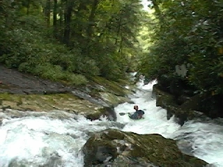
We were one of three groups on January 9th, 2007, and put on at close to minimal flows ('the good side of elfing') at 1:00 p.m., which was six hours after a 24 hr rain delivered 2.32' of rain on the Chestnut Flats gauge. The creek was much higher earlier in the day.
We goofed up and didn't put on as high up as we could/should have, but instead near the confluence with John's Branch (which is where 81 and 81C intersect). Because the FS gate was closed, we were hiking, and going up another 3/4 mile or so would have taken us to the bridge at Whigg Branch which is where we should have put in.
The Upper Santeetlah is truly a stellar run. Wood is an issue here and there. Heads up.
Be sure to check out the topo map ahead of time, and/or bring a copy.
Here is the url to a Topozone map you can mess with for the area:
http://www.topozone.com/map.asp?lat=35.33389&lon=-84.01003&size=l&u=4&datum=nad83&layer=DRG25