Big Butte Creek
Butte Falls to Netherlands Rd

| Difficulty | III-IV |
| Length | 10.7 mi |
| Avg Gradient | 65 fpm |
| Gauge | Big Butte Creek Near Mcleod, or |
| Flow Rate as of 26 minutes | 25 cfsbelow recommended |
| Reach Info Last Updated | April 23, 2002 |
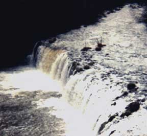
This run is fast, narrow, and shallow. It features a 15 ft. runnable waterfall, a few nice boulder gardens, many logs to go under and over, and a chance to slither between cabbage size boulders until you think your paddle and boat won't take any more. Most of the run is class II-III, but the last rapid is a full class IV which cannot be portaged and is difficult to boat scout. Cobleigh bridge provides access three miles into the run.
Description:
This run starts with a bang; The 15 ft. waterfall is runnable on the right. Put in above the fall or below the diversion dam a few hundred yards downstream. The first few miles are narrow and brushy in places and always shallow. Some logs may have to be dealt with on the fly. About a mile from the put-in the north fork comes in on the right and adds another 50 per cent to the flow. Occasional basalt cliffs provide scenery and rocks for two or three nice boulder gardens.
After three miles, Cobleigh bridge provides a poor take-out (or put-in).
The creek continues to slow, widen, and after miles of cow pasture convince you that it's all over -- 'it' shappens. Slowly the banks steepen, the river steepens and narrows, and just when you think it might get serious ahead, you realize you can't portage and eddies are scarce. After the first plunge things slow down a bit; Stop in the middle of this boulder garden and catch your breath. Hidden behind the rocks below is a full river sweeper. If you move now, all the way river right, you can slip around the roots and save ferrying in front of it later. After miles of cow pasture again convince you that it
...Jan 23, 2011
this run is chocked full of wood as of January 2011. Friends of mine reported 8 wood portages in the first three miles 1/21/11. They called it quits at the Cobleigh Bridge, so no info from there on downstream. None of the wood they encountered was in a dangerous spot and was easily spotted but not so easily portaged as brush grows to the bank in many spots on this run. FYI The falls make for a fun park & huck for those working on their boof; You can drive right to them and walking back for more laps is pretty easy
Jan 1, 1900
Put in below this diversion dam or portage left if you put in above the falls.
The creek is shallow in the beginning, but as more and more water comes in from side creeks the main creek gets wider. Bring an old boat.
This sort of thing is frequent. More so in the upper end. Never let your guard down.
The scenery alternates between this and cow pastures all the way down the run.
The basalt makes good rapids but watch out for that log.
To get to the take-out: Go north on Oregon State Highway 62 East [sic] past Casey State Park (a possible take-out). Cross the bridge over the Rogue and turn right on Crowfoot Road. You may wish to stop and park some vehicles here and organize your shuttle as parking is limited at the preferred take-out. Go up Crowfoot 2.5 miles and turn left on Netherlands Road. Go down to the creek and park upstream river left.
To get to the put-in: Continue up and down Crowfoot to the end. Turn left on the unnamed road (Butte Falls Highway) toward Butte Falls. On the way you will pass Cobleigh Road. A left turn here will take you to the access under the bridge. Continuing on toward Butte Falls, just before entering town, turn left on Falls Road (Recycling Center). Pass the sewage pond and go down the dirt road to the picnic area and overlook. Both put-ins are here