Crooked
2. Crooked R. Ranch to Billy Chinook Reservoir
July 25, 2023
| Reporter | Austin Bouck |
| Gauge Reading | 1200 cfs at CROOKED RIVER BELOW OPAL SPRINGS, NEAR CULVER, OR |
| Flow | Low Runnable |
With the long shuttle, hike in/out and portage, this one takes a day. We met at the takeout at 9am and everyone was on their way home at 3:30pm.
Below Opal Gauge was at 1200 CFS, and is only so helpful as it inidcates how the run ends after all the springs run in.
Crooked River Below Osborne Canyon USGS 140587380 was at 109 CFS and is a better indicator of how the first half of the run goes. This was pretty boney for the upper section, when I've run it in the past closer to 150 was a much better ride. Everthing did go however, and we had a fun time picking our way through the boulders to find the deep lines.
River temp was pretty warm at put in, very cold at opal dam, and green at tepid in the reservior.
We took to the crooked on a hot summer day to stay cool. In terms of access, the folks at the resort kindly reminded us that we were okay to unload boats at the hollywood road gate, but that we needed to move the vehicle to the red cinders by the church. Very short walk (like 50 yards?) and super grateful they were okay with us unloading boats closer to the gate.
After a hot walk down the hollywood road, a rocky but wide trail. Once at the bottom walk a little bit further to find a somewhat gravelly scramble down to the water with some mild bouldering.
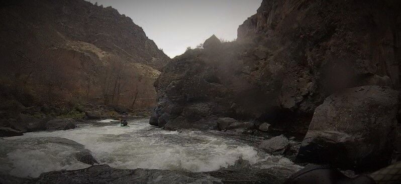
Several tight boulder gardens start the run, the 4th one being the most technical. The water is not pushy at all at this level but there was really only one or two usable channels through these rapids. Class II-III skills required to navigate even though the water itself is very mellow. This is the most technical portion of the run and you need to be able to put your boat where you want it and move it laterally mid rapid.
Things get easier for a couple river miles and you can hear springwater percolating from river left almost the entire run when you can't see it pouring from the cliffs.
Approaching 'The Wave' (Class IV) is flatwater with a horizon line with really only one entrance between two boulders in the middle of the river, wood accumulates to the left and right. Boat scouting the top end of the wave is possible by creeping up to the edge, but we couldn't get a good look at the bottom crux move until we got out of the boats.
At this level, we didn't see a clean line through The Wave. Normally at low flows you can drop in, stay center-right, then swing left/center to bounce off a rooster tail rock into the pool below. Today, the river crashed straight into a fence of three sharp boulders with a guard rock. There may have been a line river left around the boulders but the consequences of missing that move meant you would end up right against the fence.
The portage is simple but there is no trail, it's a boulder scramble across big rocks and a tree until you can reenter below the fence. I snapped a picture to show the fence from below, it looked even worse from upriver.
Once past the wave the river has some drops that are a nice change of pace, more elevation and deeper, with lots of play waves and fun eddylines in the runouts. Still intersperced are the short 'choose your adventure' boulder gardens excellent for eddy hopping and slot chasing.
Things continue to develop into shorter but steeper drops with small boof rocks as the water becomes clearer and bluer with the addition of the springwater. As the canyon gets steeper a sweeping right turn with a drop creates a wave train that was very surfable today, and small spring outlets in the canyon wall on river left that you can refill your water bottle at (opal springs water is distributed to jefferson county untreated). A fun treat a ways into the day.
Shortly after this rapid is the 'Pink trail' takeout option, exchanging an uphill hike out for the reservior paddle for those inclined. It can be identified by a large tree and a small dirt path switchbacking away on river left.
The dam is 1-2 rapids after the play wave above, and is preceeded by deep slackwater. A sign indicates the portage. A short walk and another sign shows where to put back in next to the power plant. Feel free to refill bottles again at the various taps tied into the wells.
After you put back in, the water is much colder as lower opal springs gushes from river right. Sapphire blue water cools you off as you cruise past a couple smaller rapids before hitting the largest rapid of the run (at low water). This final rapid is deep, fast, powerful, and offers multiple lines and boofs. Take a moment to make a plan and have fun with it!
With that done, the helmet came off and we beared down for 45 minutes paddling through slackwater. When you see scum and driftwood floating in the middle of the canyon, that means the river is mixing with the lake and you should get your last cooling rolls in the fresh springwater. Once past this point (in late summer) the water temp rises dramatically and turns green with algae.
The exit contains the same beautiful canyon walls and many fishermen and skiers enjoing the lake. The takeout at the bridge has a bit of a trail directly below for jumpers and rope swingers to clamber back up, and provides a good enough path to carry boats back up to the road.