Oconee
At Milledgeville(Lower Oconee)
July 10, 2006
| Reporter | Will Wagner |
For a river runner this section of the Oconee also provides a good paddle. If you head north on North Jefferson St. leaving Milledgeville you will soon come to a 4-way stop at Log Cabin Rd./Sinclair Dam Rd. Take a right headed east onto Sinclar Dam Rd. and this will take you past the country club to the Dam at the southern tip of Lake Sinclair. This is the put in where the Oconee River begins from the lake. Here you will bypass Furman Shoals which is a rock outcrop blown up in order to build the dam. It is a marshy area most of the time but when big water is released it quickly becomes unrunable class VI whitewater. Your paddle begins directly around it and around Carter Island where you join the main body of the river.
This paddle is flatwater until you reach the rapids at the highway 22 bridge other than a mild class I turbulence called Turtle Shoals about a mile past the put in.
It is roughly a 3.5 mi float until you begin to approach the highway 22 rapids. You warning sign is the gaging station which is a concrete tower shooting a stream into the river, you have about a 100 yards to make your decesion.
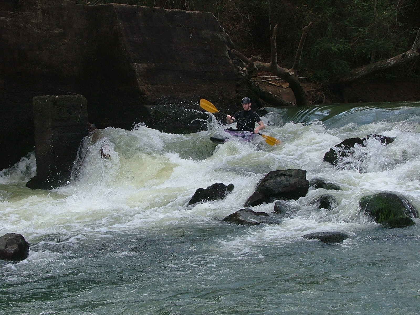
Here you may choose to run river right around Buzzard Island. This will take you to 'Grist Mill Rapid' labeled here as 'Powerhouse Rapid.' This is my favorite way to go and the only way to go at low water. Like instructed here the line is just right of center and just left of the mill. At higher water this creates a nice climbing wave. You can collect in a eddie pool just upstream of the mill before running the rapid and recollect in the eddie behind the mill to play.
If the river is high enough you may decide to run the upper drops on the left fork of the river. At high water this is where the river naturally takes you. It's a good idea to land your boat onto the small island in the middle of the river to scout out your options from there. You may walk out onto it into the eddie below and view the rapids from downstream. Far river right where most of the current goes is a class II called 'Tombstone Rapid.' This is a good run with no specific line as long as you avoid the 'Tombstone' pin rocks.
The center rapid called 'Baldwin's Dip' is a more enjoyable class II run while the line is slightly right of center, then you just bump over the main wave and ride the wave train afterwards.
The far river left rapid seperated from the other two called 'Oconee Falls' is only runable at real high water and just tumbles over small rocks. After running any of these three upper drops you can ferry down to 'Grist Mills Rapid' and play. If you swim in any of these three rapids you will get beat up. I am not sure of any rebar, but these rocks have gravel teeth.
If the water is low the upper drops do not exist and you will have to portage the shoals below them to the current that comes out of the mill. You can view some fish activity in the pools in the shoals.
From here you can take out at the highway 22 bridge or paddle another 4 miles of flatwater to complete the Milledgeville Section of the Oconee. You can camp out at low water on sand bars to make an overnight trip, but beware of the rising water or sleep in you boat. There are also some rock outcrops on the river bank below the only houses on the the river at Pebble Hill. The take out will be a concrete boat ramp on the right. To get there by road you go South on Hwy 112(Vinson HWY) out of Milledgeville and when you see the prison you take a left down the road before it(there is a brown boat ramp sign.)