Abrams Creek
2. Abrams Creek Campground to Hwy 129(Lower Abrams)
March 22, 2021
| Reporter | Watts Hudgens |
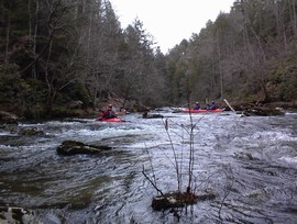
March 20, 2021. In a Star Slice cataraft. Level on the Little River gauge was about 3.4ft and two days previously quite a lot of rain fell in the area. Nearly three inches in my cheap, backyard rain gauge in Knoxville and the TVA website's CadesCove rain gauge recorded 2 inches of rain 48 hours previously. During the drive to the put-in I could see that the feeder creeks were in great shape though running with clear water. My assessment is that these conditions are minimum for a Star Slice cataraft or a small raft but if just using canoes or kayaks it is a very nice level indeed. Moving very slowly, solo in my cataraft, and stopping several times to scout for trees, I took 5 hours from launch to Takeout including the slow paddle across the lake. About a half mile downstream from the put-in I had to drag my boat over a river-wide log; the hemlock was mostly free of branches and the water is slow in the area so it was an easy portage. From that spot over the next three quarters mile there were a few minor, nuisance pieces of wood but easy to avoid at my water level. Stopped for lunch at the old ruins on river left at Mill Branch. About a half mile downstream from Mill Branch, where the river takes the first severe oxbow turn to the left, in an extended series of winding ox-bows, I saw the river-wide jumble of trees/strainers mentioned in the Feb 2021 note/comment. I ferried over to river left and dragged the cataraft around the jumble of trees. The water is moving here but I had plenty of distance upstream to notice the mess. Historically there is often a jumble of trees at this spot on river right and there are signs of beavers in the area. No other strainers seen until the canyon/gorge section which I would describe as a series of class 2 and possibly 2+ rapids that come at you far, far more frequently than anything else seen in the previous 5.5 miles. Two of these class 2's are quite close to each other and the other three or four have some short gaps for recovery between them. Two of them are at sharp bends in the creek where you cannot see the runout and I halted and walked downstream a bit first to get a clear view of any hidden strainers. Several of these class 2's are formed by extended ledges or jumbles of rocks from bank to bank and in two of them medium to large-sized trees lurk in the channels at kayak chest or kayak-head height. In the runout of one of these class 2's a massive diameter log crosses the channel at about five feet above water left. At my water level it was easy to duck underneath. I was graced with a very unusual tailwind of northeasterly winds to help me paddle the mile to the US129 bridge and Takeout.