Chattooga
Section 3 - Earls Ford to Route 76 Bridge
January 10, 2026
| Reporter | Matthew Albitz |
| Gauge Reading | 4.5 ft at CHATTOOGA RIVER NEAR CLAYTON, GA |
| Flow | High Runnable |
After getting up early and watching every gauge we could think of spike, Taylor Sobczak, Sammy Lockwood, and I decided to head to the Chattooga. We met at the whitewater shop and kicked around ideas. We knew the level was spiking hard, but at that time, it had only come up to around 2’.
I convinced them to do Sandy to the bridge because I figured it would probably only get up to around 3’. It was also for this reason that I chose to paddle my Dagger Medieval. It was raining so hard that we wore our dry suits to load boats and run shuttle. As we hike down Sandy Ford none of us could believe the amount of water flowing through every depression in the topography, and the gushing waterfalls that are normally just wet rock slabs. This walk is when it really occurred to me how high this river may be and made me yearn for a larger boat. Sandy Ford was unrecognizable, there was way more water than any of us had ever seen, and I really started to get nervous.
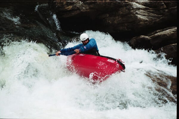
I knew that the narrows would be where we truly understood what we were up against. I went for the traditional line through the start of the narrows, and I narrowly missed a massive hole. I watched a Firecracker get tossed around in said hole. He escaped and we eddied out before running the second part of the rapid. After nearly getting back-endered in what I thought was a clean line, we got through the second part of the narrows and quickly floated down to second ledge.
We made the good decision to scout, and with great difficulty we were able to lay eyes on it. The main line was dropping into a hole with the boil line probably 10 feet from the ledge. That wasn’t going to work in our low volume boats, but I spotted a line on the far side of the river, probably 60 feet from the bank we were standing on. It looked ok, a break between bad looking holes that would be smooth as long as you were on line. By the time I got back to my boat I noticed all the waves in the middle of the river were now larger and some of them had turned into holes. The river was still spiking hard, and my line now looked a lot less inviting. The ferry to that side of the river was incredibly hard, but I turned my boat downstream in time and was able to ride a massive wave through a part of second ledge that is typically dry rock. We enjoyed big bouncy waves and holes before deciding to scout Eye of the Needle.
There were two lines that looked ok, both involved tight moves dodging serious pour overs on both sides (at this point the rock the usually directs all the water to one side was large pour over that looked like a serious beatdown if you entered it). On top of this, as far as the eye could see there were large waves and holes not unlike something you’d see on the Olympic section. We decide to portage because of the remoteness and potential of a very long swim and the loss of a boat very far from civilization. We then enjoyed flying through massive waves and enjoyed some good surfing and big eddy lines.
We scouted Painted Rock and I was glad we did. The rock in question was completely underwater and creating an ugly looking hole. The normal line on river right had its own bad looking hole so the line we ran was middle left driving as hard left as we could to steer clear of the painted rock pour over. That was a fun ride! From Thrifts to the Bull was more of the same big water, you can go places that are normally completely dry and you will pass eye popping holes constantly. By the time we got to the Bull, it was at 4.5’ so we portaged made the ferry to the beach. We were thankful to have made it off the safe.
Overall, this was a fun but scary day. At one point I heard my friends yelling at me, they were alerting me to the 50-foot tree that was in the river next to me. We all eddied out and got to watch it wrap around a rock. It sounded like thunder. This is no place for those unfamiliar with the Chattooga and yet most of the lines are completely different than those at normal flows. This is a big water run, and a swim here could end very badly.