Jacks River
Jones Mill/Bethlehem Church to Conasauga Confluence(Upper Jacks)
February 3, 2013
| Reporter | Simon Bishop |
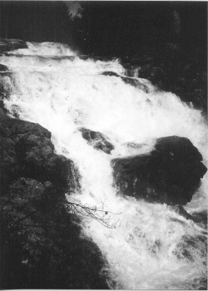
For several years the ongoing question of the falls being ran or if they were runnable has to be resolved. I have lived here all my life and have been paddling in the cohuttas 17 years now. To the best of my knowledge Jacks falls has never been ran in a craft. Numerous injuries have happen from hiking and swimming around this waterfall. Rescue isn't an easy task anywhere in this wilderness. I have seen the falls at many different levels and would say its a no go. Location of it has to be considered as should risk vs gain. I have carried in on Beach Bottoms trail 3.5mile an put in below the falls an took out at the steel bridge two times now. Once was really scary high water with campgrounds flooded in the spring of 2000. The huge boulder mid stream at the bottom of the falls was under water. Way to much water created some terminal holes and lots of trees floating down with us. Next trip was caught at a med/low flow. It made it a nice run but was alot of work for what you get. There is 3 class 4 to 4+ drops just below the falls. The second rapid below the falls slams you against a wall on river right at lower flows. The last of these rapids is a low slide against a wall on river left. After these rapids the river becomes similar to the nanty but with a few more 3's and trees. The section below the falls has been ran a few times. The 8mile sect above Jacks falls has no description that matches what a few others and I have seen. The steepest section is about 1mile below the 1st jacks ford on the trail hiking down from Dally gap. This steepest section begins where the old railroad bed 'now Jacks trail' had to be cut in and away from the river due to the terrain. This has been called the Highcut by loggers and locals for decades. The river can't be seen from the trail and is the rhodo hell section/upper gorge of Jacks. A few rapids I would call V's but is for sure continous class 4. It is about 1/4 to 1/2mile before the river intersects with the trail again. The next few miles below the Highcut is class 3+ with a few 4's. It calms down a bit just upstream of Penitentiary branch and picks back up again just below lost branch. Around Murray creek there is a 6ft ledge followed by a 10ft slide an ledge. The river calms down again untill Jacks Falls. So the section below the falls is not the most continous mentioned from others. I have heard of 1 group who ran the whole river and described the upper gorge well. Many small settlements were along the river. In the early 1900's my grandmother washed clothes just below the falls for the loggers earning about 50 cent a day. That is how she met my grandfather who worked as a logger. Penitentiary branch was a logging camp for the workers. Only having Sunday off work they didnt have time to travel back to their homes or to visit family so it felt like a penitentiary to them. And yes an indian name Jack piggy backed folks accross the river for a small fee to later hince the name Jacks river. Hope this may help any questions of this beautifull and history filled river.