North River
East Branch(Halifax Gorge(VT) to Colrain(MA) )
March 11, 2016
| Reporter | Brad Walker |
03/10/2016 - Put in about 1/4 Mile closer to MA Line: 42.736484, -72.724398 (coming from MA, cross steel bridge then look for road bend to right - see leaning utility pole and parking is right there - steep kind of crappy embankment to river) ||| |||
Level 3.6 with light drizzle and ground thaw (minimal snow melt) 60F. ||| |||
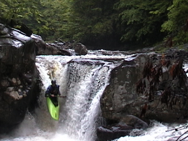
Anyone concerned about Class II and seeing the associated photo of James doing a big drop... at the 3.6 level there are no drops of that magnitude (I'm not even sure that photo was from this section of river at all... I'll pay more attention on my next run).||| |||
Very nice run with minimal development to be seen from the river. When leaves are out you will feel like you're on a very secluded creek. Edge of bony at 3.6, bring your rock-beat paddle - rocks all river-rounded so your hull should be just fine.||| |||
Water cold, air warm made for some very cool river fog. Plenty of spots to do some surfing, a few spots that look like at a higher level offer some cool ledges to play with. If you like classic New England, you'll enjoy the old bridges to pass under, farmhouses to float by and such. ||| |||
Very little flatwater but enough breaks between rapids to munch a Cliff (shameless AW Sponsor plug) Bar and rehydrate. Nice active paddle without being strenuous.||| |||
Trees close to banks throughout and many are beginning to fall in - at least 6-10 were leaners debarked by ice flows so beware strainers will be popping up and some were leaning low enough that once it hits the 6' range they'll be beyond ducking and officially designated as strainers. At take-out run Left/Center as there is a log blocking the far right channel under the bridge.