Stones, W.Fk.
Barfield Crescent Road to Nice Mill Dam
| Difficulty | II(III) |
| Length | 17.8 mi |
| Avg Gradient | n/a |
| Gauge | West Fork Stones River at Murfreesboro, Tn |
| Flow Rate as of 1 hour | 128 cfsbelow recommended |
| Reach Info Last Updated | February 11, 2015 |
This long stretch is flatwater, punctuated by numerous shoals, a few ledge/waves, and a couple dams. Caution may be required around dams as they may form uniform hydraulics at many flows. (Scout, and be prepared to portage.) Various alternate access points allow trips of varying lengths. As well, the best feature(s) may readily be done as park-and-play.

Just upstream of a bridge on a dead-end stub of road, the river has a likely a low-head dam, with attendant concerns regarding boil line. Most boaters at most flows may be best advised to stay well clear, putting in below this dam.
Just downstream of the listed putin a rocky outcropping marks an area of shoals.
It appears there may be some shoals or possible feature leading to and under this bridge. Shoals extend downstream.
Flanking the one-mile mark from the listed put-in, it appears there may be three back-to-back rocky squeezes.
Heading into the footbridge, there is a short stretch of rocky shoals.
Apparent blocky rocks may (at some flows) make some disruption (play?) in the stream.
As you arrive at Hwy.99 (New Salem Road), you encounter Sterling Farmer Dam. CAUTION! This is likely to be a low-head dam with keeper hydraulic at many flows. Do not be deceived and tempted by this short drop without full consideration of the possible hydraulic. It appears there may be a short, constricted, bypass channel around the right side.
A (very minor) shoals may exist as you come into this park. This may serve well as alternate access for shorter trips.
Not far downstream of this bridge, a narrowing and shoals will be encountered.
Minor shoals as you round a smooth right-hand bend.
Very minor shoals and a narrowing of the river lead into Bridge Avenue. At some flows, there may be some fine waves developing here.
After passing under Hwy.96 (Old Fort Parkway), and passing Stones River Mall (river-left), as you head to a bridge crossing, you may find some minor rubble/obstruction (likely completely covered and making nothing interesting at good flows).
As you encounter the next footbridge (for Stones River Greenway System), Lytle Creek enters from river-right. Rounding the bend you'll see the Medical Center Parkway bridge just downstream. Be alert for a dam, which likely forms a keeper hydraulic across most of the stream. There appears to be a step-down-bypass to river-left. Passing under the highway, it appears there is another dam, this time without any apparent bypass. Scouting is advised (perhaps best done while running shuttle, to be fully aware the situation here before putting on upstream!). Portage may be required at many flows.
As you head round a bend (near the Murfeesboro Bark Park, off College Avenue), a maze of islands breaks up the flow. Continuing around the left-hand-bend, a short ledge/wave will be encountered. At some flows, this may offer some play.
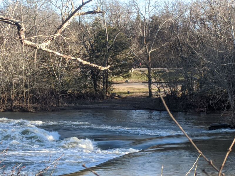
About 0.2 mile below Murfreesboro Road (Hwy.42/70S/1) (as you pass Stones River Country Club on river-right), more treed islands divert the flow. This signals the approach to (perhaps) one of the best features of the run.

Good flow for this feature is 300 CFS to about 650 CFS, and it can be surfed up to 2000 CFS (6 to 7 feet). This is a fun place to practice, but beware it will try to flip you at higher water levels. When it does, tuck up tight, its a little shallow, and head-busting rocks do wash out of the feature from time to time during high flows. (When the water goes down, the locals go back and put the rocks back.) Go give it a try and tell us what you think on our Nashville Whitewater Facebook page.
This is easy to do as a PnP. Go to the liquor store/ tobacco outlet at 2122 N Thompson Lane and park out back. Walk down the hill to the Greenway and go left. In about twenty yards you will see Harker’s Crossing Plaque, follow trail behind that to waters edge. Launch your boat and paddle around the trees to Harkers hole. To take out, paddle down to the wooden dock and get out there.
Before getting to N.Thompson Lane, it appears some interesting bedrock flanks the river. It is possible some features (waves/holes) may occur here (before and after the bridge) at some flows.
As a side note, on river left at this point is a 570-acre park, Stones River National Battlefield, memorializing a key battle in the American Civil War.
As the river heads into and around a right-hand horseshoe-bend, it encounters a fine area of shoals.
Before getting to Blanton Avenue, there may be some area of shoals and rips (waves). Immediately downstream of the bridge (at a major rocky prominence on river-right) there may be an interesting ledge.
As Sinking Creek enters (river-right), a number of islands divert the flow. There may be some interesting maneuvering (and play?) possible here at some flows.
As the river passes the filtration plant, look for a very low weir (dam). It appears likely not to cause any problem, and (at some flows) may actually present some play potential. (If anyone has contrary information, please comment below!)
As Hwy.840 comes into view, some very light shoals/rips may occur (before and immediately after the bridge).
Interesting (at least as of present satellite imagery), if you zoom in to max resolution, you will see a group of three paddlers at this point!
Various random/intermittent areas of light shoals are encountered leading to this point, where there may be a bit of a ledge/chute.
Just downstream Overall Creek enters from river-left.
Immediately after passing Sulphur Springs Road, be cautious of the dam just downstream. It appears to be broken out river-right to form a bypass (which could offer play opportunities?). At times of high flow, it may form a dangerous hydraulic.
Anyone having specific knowledge about this or any other features on this run is highly encouraged to help out your fellow boaters via the 'Add a Comment' button which should appear below for all registered, logged-in users.
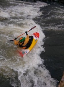
Pipeline Wave/Hole forms under the Medical Center Parkway bridge just downstream of Ransom's Mill Dam. At lower levels it's a great entry-level surf with eddy access river left. At higher levels it can form a great freestyle hole where every trick is possible.
Mar 28, 2020
Ran on 3/27/2020, water level 650 cfs.
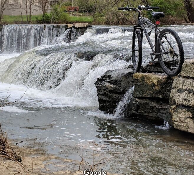
Put in at parkway dams (mile 7.95), both were runnable. Top dam is about 8 feet tall and is run via series of ledges on the left side. Scout river left on greenway. Drops are fairly straightforward though there is a fairly retentive hole at the bottom. Whatever level you run this at, be wary of the potential for dam hydraulics nearby. Other than that, this drop is probably class III. The second dam is about a 3 foot drop and at this water level a large, 10-foot wide tongue provided sufficient flow to avoid any hazard of entrapment in dam hydraulics. Probably a class I at this level. Also scoutable river left. See pictures for First Parkway Dam rapid and Nice Mill Dam rapid.
We ran about 2.5 additional miles with one notable ledge (class I or I+, near the Bark Park) as well as Harker's Hole. Other than that not too much to note although it's a surprisingly nice and isolated river for being in an urban area. Saw several kingfishers and herons.
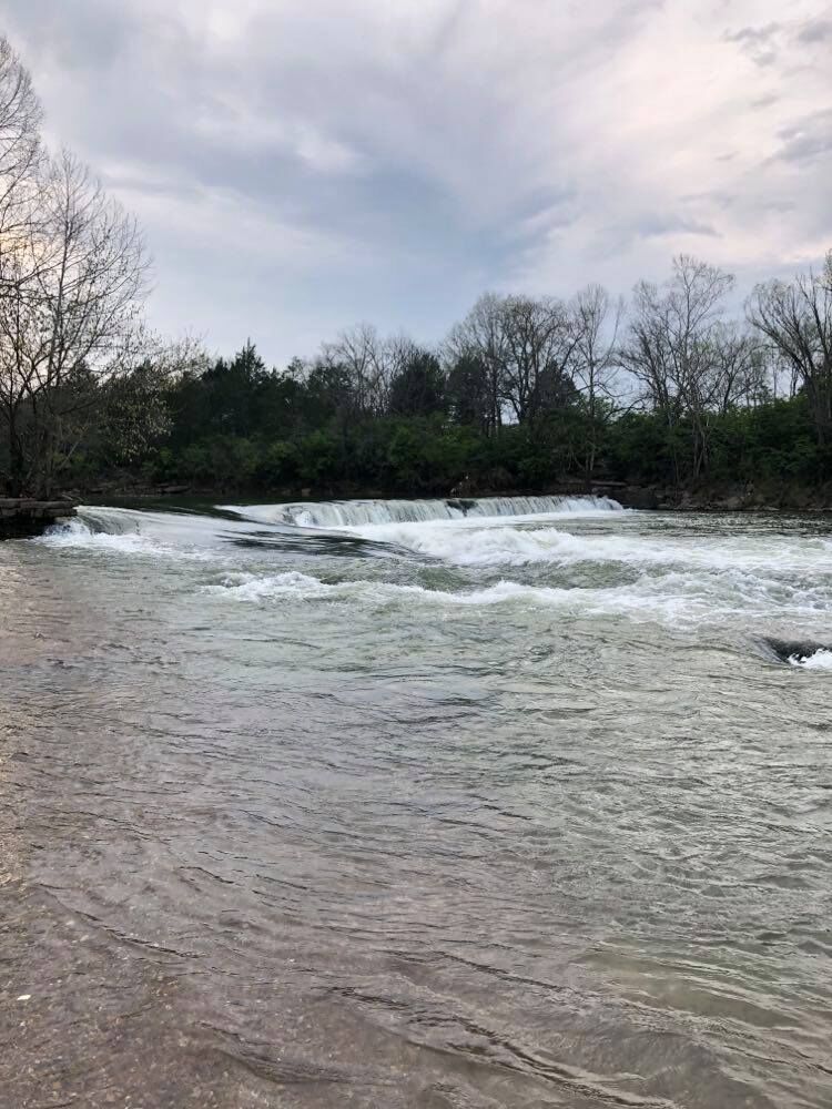
We took out at a greenway trailhead and headed a few miles downstream to run the bypass at the Nice Mill Dam. At this level, the 8-10 foot dam can be bypassed via a large, gently sloping tongue on far river right. Be aware that running too far to the left on this tongue might get you caught in a really nasty looking hole which may in turn move you into the dam hydraulic.
After the tongue, a nice playful class II hole/wave follows about 100 feet downstream. This rapid offers great park and play opportunities and at this level was surfable.
Feb 13, 2014
Philip Byard at Harkers Hole.