| Difficulty | I-II |
| Length | 4.5 mi |
| Avg Gradient | 10 fpm |
| Gauge | Black Earth Creek at Black Earth, Wi |
| Flow Rate as of 1 hour | 39 cfsbelow recommended |
| Reach Info Last Updated | February 23, 2019 |
River Description
A fun easy run for beginner whitewater kayakers, with a couple of spots which may offer some decent wave/surfing potential at good flows.
There are some options for shorter or longer trips, but the section as we have listed is likely to be the best bang for the whitewater buck.
River Features
Put In
Access PointDistance: 0 mi
Overview
OtherDistance: 0 mi

The following video shows a good sampling of this run. We normally would not feature video of recreational kayakers paddling without wearing life jackets (PFDs), however we will note that this creek (at most paddleable flows) is generally shallow and easy enough to stand up and walk out of, so it is a minor enough offense we will let it pass, in the spirit of 'It's all good fun.' And, we will note that they all appeared to have PFDs 'readily accesible', which is all the state law specifies. Additionally, the date noted on the trip was July 7, so air and water temperatures were quite fine. Flows at the time of this video would likely have been falling from about 200 cfs down to about 150 cfs.
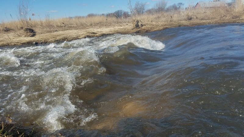
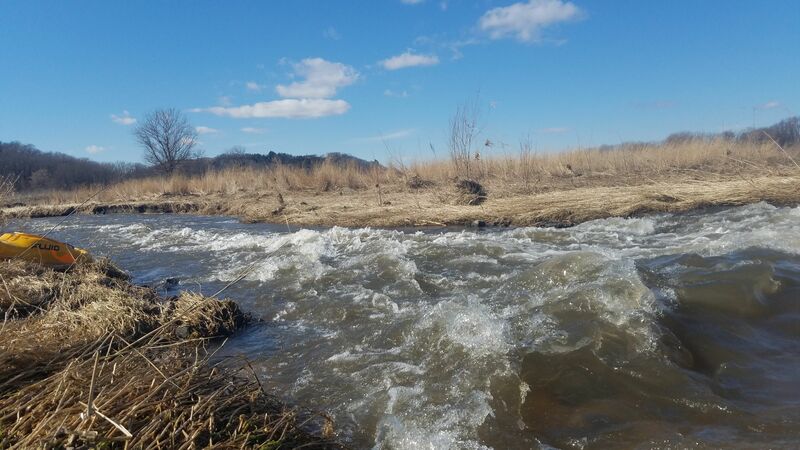
Wave(s)?
PlayspotDistance: 1.04 mi
Satellite view shows what appears to be a feature (or quick pair of features) at this location. Within 0.2 miles downstream ('just around the bend') there is possibly one more as you head into a series of S-turns.
The Straightaway
OtherDistance: 1.42 mi
Just past 'the Esses' (S-curves), you'll reach a stretch of fairly straight river (creek).
On your left run the railroad tracks, and (just a little ways down, and across the tracks) Lake Marion, really little more than a pond, but with a small park. Just west of that lies Mazo Bluff.
On your right lies a fine section of Wolf Run Trail, running though the Wolf Conservancy (named for the family which allowed a perpetual easment to the Natural Heritage Land Trust and Dane County).
Reportedly, the reason for this section being this straight is that the creek actually used to feed into Lake Marion, which was formed by a dam on the creek. However, the creek was rerouted, and the lake now exists apart from the creek.
Just as you get to the downstream end of Lake Marion, the creek takes a minor zig-zag and heads under Hwy.14.
Tandem Trestle
OtherDistance: 2.26 mi
There are back-to-back railroad trestles, as two rail lines merge immediately east of this location. Reportedly, passage here can be a bit tricky (especially for novice paddlers). The first trestle is usually best navigated to the far right, as debris tends to block left and center passages. The second trestle is generally best navigated to the left.
Paddlers are cautioned to avoid contact with the wooden trestle supports, as they are likely treated with creosote, which can cause rashes and burns, and is difficult to remove from skin and clothing.
State Street (aka CTH.Y)
Access PointDistance: 2.76 mi
This may be a very reasonable alternative exit/access.
Bridge Street
OtherDistance: 3.06 mi
With steep banks and posted 'No Trespassing', we strongly recommend against attempting any launch or landing here.
Lions Park Pedestrian Bridge
Access PointDistance: 3.7 mi
It would certainly be possible (as some folks do) to use Lions Park as your take-out (cutting out about a mile of paddling which is mostly uninteresting from a whitewater perspective). However, the take-out area is much less convenient, and you will have a longer carry (though not all that long) to your vehicle, than if you use our listed take-out.
We would also note that (on all maps we can find) river-left is 'Lions Park' (with swimming pool, ball diamonds, etc), while river-right is 'Walking Iron County Park'. A handful of other write-ups (from various paddling blogs and websites) mention taking out at Walking Iron County Park. This seems unfortunately misleading, as the parking for that park is far away from the creek. Anyone plugging that park name into a mapping app will be routed far away from where they really want to be!
Take Out
Access PointDistance: 4.75 mi
Trip Reports
Log in to add a reportDB
Dennis Boettjer
May 28, 2019
bring bug spray!! as of 5/26/19 there are three places you will be blocked by fallen trees. 2 of the places - easily portage. the third there is an electric fence on one side of the stream and the other side is a steep drop off. i went to the left and lifted my kayak over the fallen tree.