Klamath
01. Keno Dam to Pioneer Park West or Moonshine Falls(Keno Run)

| Difficulty | III |
| Length | 8.8 mi |
| Avg Gradient | 50 fpm |
| Gauge | Klamath River at Keno, or |
| Flow Rate as of 32 minutes | 654 cfsbelow recommended |
| Reach Info Last Updated | November 20, 2025 |
Restoring the Klamath River: A Historic River Reborn The Klamath River now flows freely for the first time in more than a century. The removal of the four lower Klamath dams—J.C. Boyle, Copco 1, Copco 2, and Iron Gate—marks the most ambitious river restoration effort in U.S. history. For [...]Read More
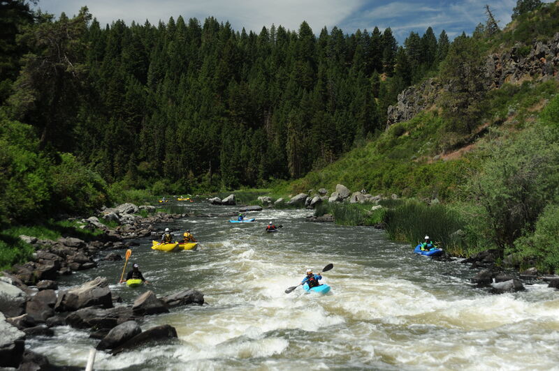
The Keno Run on the Klamath River offers Class II/III whitewater, diverse high desert forest scenery, and excellent opportunities for fishing and bird watching. The upper five miles of the run are mostly remote, except for the Keno Dam and a transmission line crossing. Below this, the river now flows freely where the J.C. Boyle Reservoir once inundated the river. Paddlers can take out at Pioneer Park West (just below Highway 66) or extend the trip by almost two miles to the just below the site of the former J.C. Boyle Dam, which includes one Class III and one Class IV- rapid.
Keno Canyon Section: Keno Dam to Former Reservoir Footprint
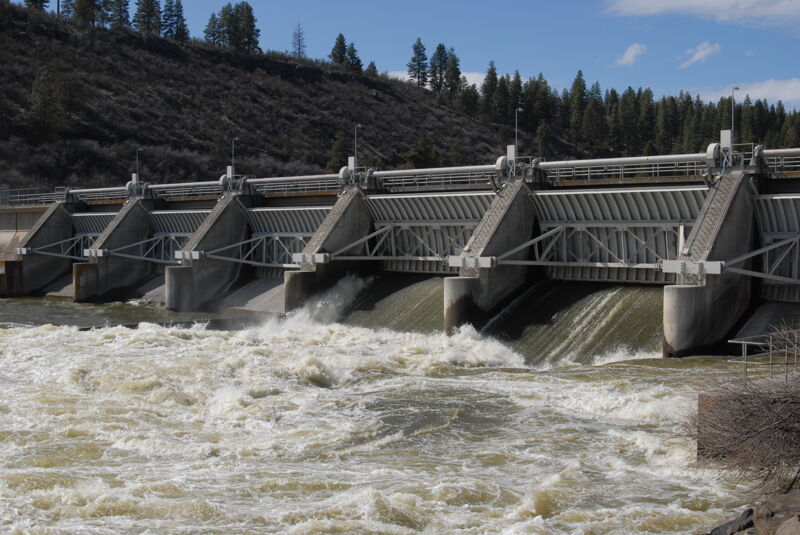
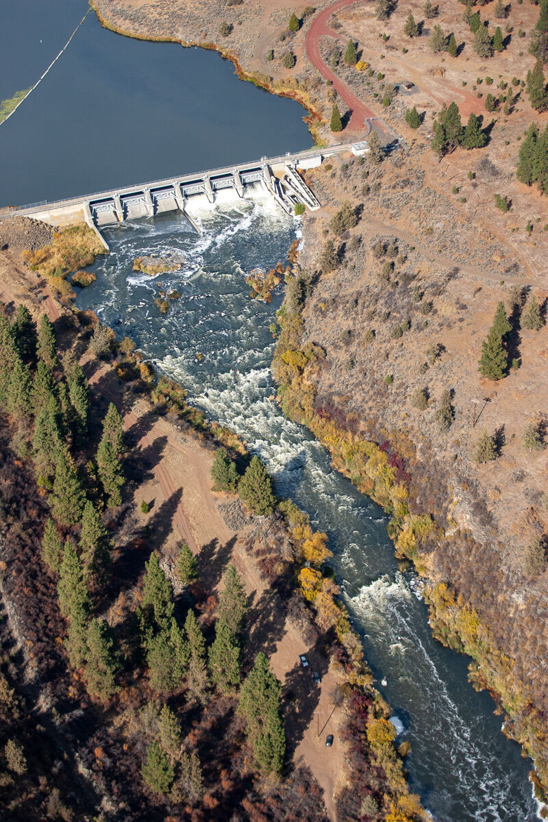
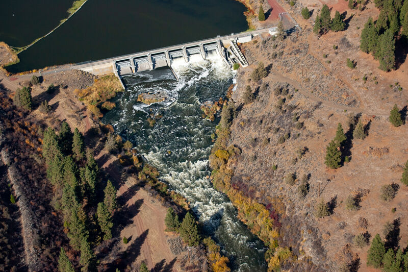
The run begins at the base of Keno Dam, accessible year-round on river right via Old Wagon Road. This road is heavily rutted and requires a high-clearance vehicle. PacifiCorp’s four downstream dams were removed in 2024 but Keno Dam remains and is now under the management of the U.S. Bureau of Reclamation.
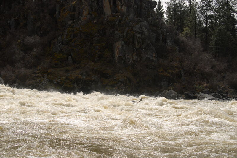
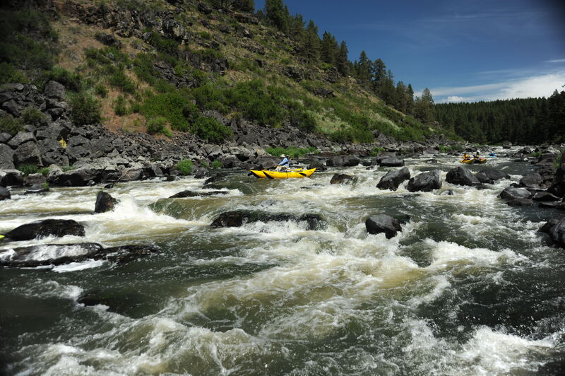
For about five miles, the river features continuous whitewater with notable rapids in a distinct but shallow canyon. Rapids include the Keno Wave and Meatball, a more challenging rapid near the end of this section.
Former J.C. Boyle Reservoir Section: Upstream of Pioneer Park West
The breach of J.C. Boyle Dam on January 16, 2024, quickly drained the reservoir and extended the free-flowing reach of the Keno Run. After Meatball, the river flows thorugh the former reservoir footprint, becoming low-gradient for two miles before reaching Pioneer Park West. This access point, located just downstream of Highway 66 on river right, will reopen as a river access facility in spring 2025. Until then, paddlers can take out at the Highway 66 bridge within the right-of-way. Continuing past Pioneer Park West to the Moonshine Falls River Access 1.5 miles downstream, increases the challenge of the run by adding one Class III and one Class IV- rapid, Moonshine Falls, which may not be eas
...
Keno Dam is the only dam remaining on the Klamath River, now owned and operated by the U.S. Bureau of Reclamation. Its ownership was transferred from PacifiCorp in 2024. Link River Dam, upstream on the Link River, controls flows from Upper Klamath Lake into the Klamath River and into the Bureau of Reclamation's Klamath Project.
The Old Wagon Road put-in is on river right just below Keno Dam. The road requires a high clearance vehicle. The land here is managed by the U.S. Bureau of Reclamation as of summer 2024 (it was formerly owned by PacifiCorp).
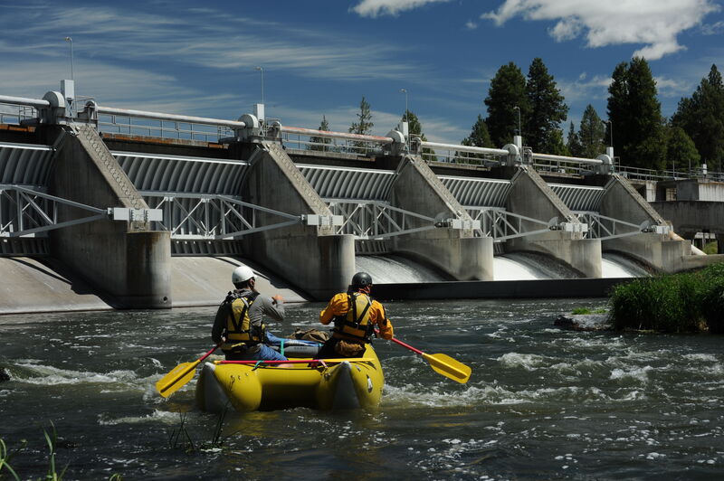
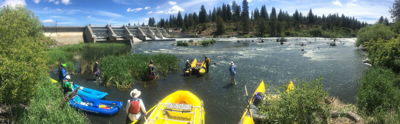
The former put-in at the Keno Recreation Area on river left that was owned and managed by PacifiCorp as a recreational facility associated with their hydropower project is closed and road access to it is gated at Highway 66. Kayakers can walk in to access the Keno Wave. American Whitewater is advocating for transfer of the facility to a public land manager and we expect it will be owned and managed by the State of Oregon for day use. The road to the base of the dam on river left has a cable across it and requires an approximately 100 yard walk to access a launch area at the dam.
A fun play spot that can be accessed from the Keno Recreation Area. Unfortunately the recreation site is currently closed indefinitely and boaters must walk in from Highway 66.
Final rapid before the river tapers off with the lower gradient reach through the former reservoir footprint that extends down to Pioneer Park and Moonshine Falls.
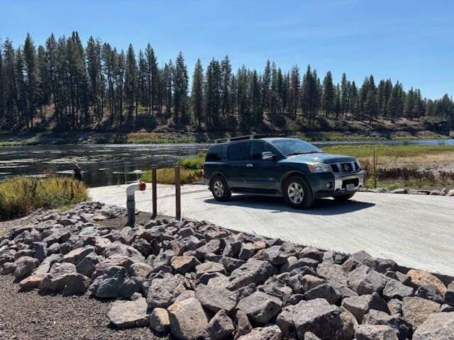
Pioneer Park West is the new river access facility that serves as the take-out for the Keno Run. It is on river right just downstream of the Highway 66 bridge and is open for day-use. The new facility features a concrete boat ramp, a turnaround loop, parking, restrooms, picnic tables, a bike rack, and other amenities. The park area will be open in warmer months only but the river access will be open year-round. It is a day-use site open from 7 am to 7 pm, year-round but the access road is not maintained in winter and may be impassable or temporarily closed due to weather. Nature ultimately dictates access—please use good judgment and avoid attempting the access road drive in unsafe conditions. When snow makes Pioneer Park unreachable, boaters typically use the HIghway 66 bridge right-of-way to access the river; be aware of traffic hazards if doing so.
J.C. Boyle Dam, originally named Big Bend Dam, was an earthfill dam with a concrete spillway that included three gate structures. The dam diverted the river into a suspended pipe and a concrete canal that delivered nearly off the the river's flow to a downstream powerhouse with two turbines that provided a total generation capacity of up to 98.7 MW. The river was dewatered between the dam and powerhouse, ponly lowing during special spill events or unusually high winter flows.
The J.C. Boyle Dam, part of the Klamath River Hydroelectric Project, was issued its original federal license in 1954. Construction began in 1956 and it was completed in 1958. The project license expired in 2006. On January 16, 2024, the dam was breached with an explosive charge to open a low level outlet and the JC Boyle Reservoir was completely drained. The dam was fully removed by September 2024, with river and reservoir footprint restoration ongoing.
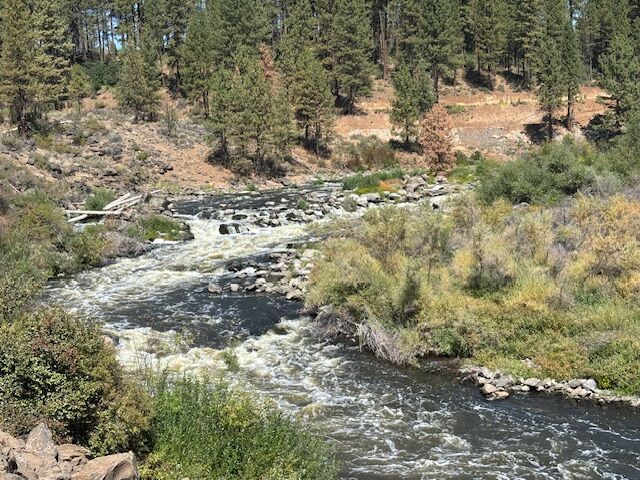
Upper wGawgos kčal (Upper Moonshine Falls) is a rapid that is re-defining itself now that J.C. Boyle Dam no longer sits atop it. It is currently located where the cofferdam once was, which is the likely source of the gradient at this location. The rapid is quickly headcutting upstream, so its location may change. Scout (or portage) from river left. The main drop comes at the sharp right bend in the river where the dam used to be. After dam removal in fall 2024, it was initially steep and rowdy with a boisterous wave/hole but following the first winter of high flows in early 2025, the rapid is now much more subdued. The rapid then levels out before the river bends left and flows into the original, but altered, wGawgos kčal (Moonshine Falls or Fishing Falls).
About this rapid's name: wGawgos kčal (pronounced wah-GOW-goss k-chahl) is the Modoc language name of the falls now commonly known as Moonshine Falls. As noted above, this rapid is located upstream of the falls where J.C. Boyle Dam once stood, therefore it is referred to as the upper falls.
For millennia, Native Americans gathered at wGawgos kčal (Moonshine Falls or Fishing Falls) to fish. In 1958, the falls was silenced when PacifiCorp built Big Bend Dam almost directly atop it. Over time, the exact location of the falls faded from memory. Had it been blasted away to make room for the dam? Or did it lie just upstream, submerged but intact?
The answer only became clear after the dam—later renamed J.C. Boyle Dam—was removed in 2024. Evidence suggests the falls was altered during construction, but much of it remains just downstream of the former dam site. As of late 2024, the newly undammed river continues to shift through wGawgos kčal. Instead of the distinct rocky ledge shown in pre-dam photos, the site now resembles a congested, rocky, brushy channel. Boaters should be aware of significant pin potential.
About this rapid's name: wGawgos kčal (pronounced wah-GOW-goss k-chahl) is the Modoc language name of the falls now commonly known as Moonshine Falls.
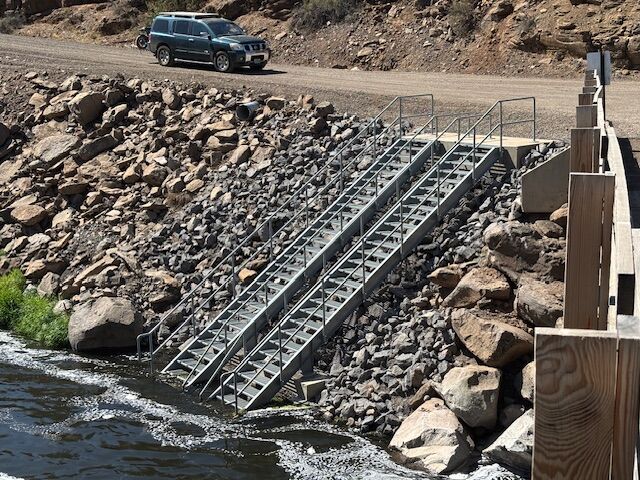
Moonshine Falls river access is downstream of the falls on river right. This access opened to the public on August 1, 2025 and include stairs to the river, a raft slide, parking, restrooms, and other amenities. It is accessed via a dirt road off Highway 66, about 1.6 miles west of the Klamath River bridge. It is open as a day-use site, 7 am to 7 pm.
Sep 18, 2025
Mostly photos of river accesses.
Jun 24, 2025
We put in at Keno Dam using Old Wagon Rd (which definitely required high clearance). Paddled down to Topsy Camground where we were staying - about a mile past the Hwy 66 bridge. Flows were 950 and dropping and while we made it down it was quite low, especially on the second half. The first few miles had consistent rapids which would be fun with a little more water. The flat stretch about the Hwy bridge was very slow at these flows. Getting out at the campground was a little tricky with the bank being mostly mud but that will probably change as the bank recovers.
Apr 11, 2025