Klamath
01. Keno Dam to Pioneer Park West or Moonshine Falls(Keno Run)
Sep 18, 2025
Mostly photos of river accesses.
Jun 24, 2025
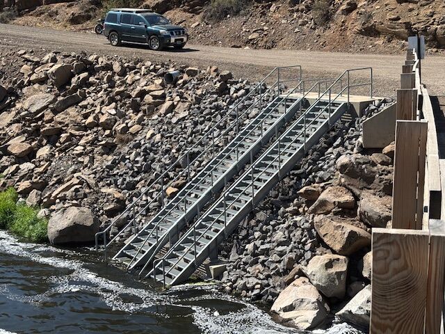
We put in at Keno Dam using Old Wagon Rd (which definitely required high clearance). Paddled down to Topsy Camground where we were staying - about a mile past the Hwy 66 bridge. Flows were 950 and dropping and while we made it down it was quite low, especially on the second half. The first few miles had consistent rapids which would be fun with a little more water. The flat stretch about the Hwy bridge was very slow at these flows. Getting out at the campground was a little tricky with the bank being mostly mud but that will probably change as the bank recovers.
Apr 11, 2025
Apr 7, 2025
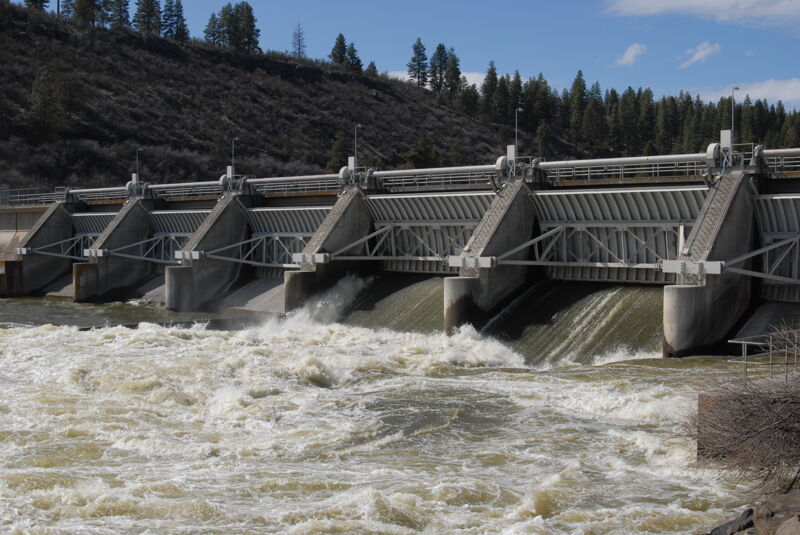
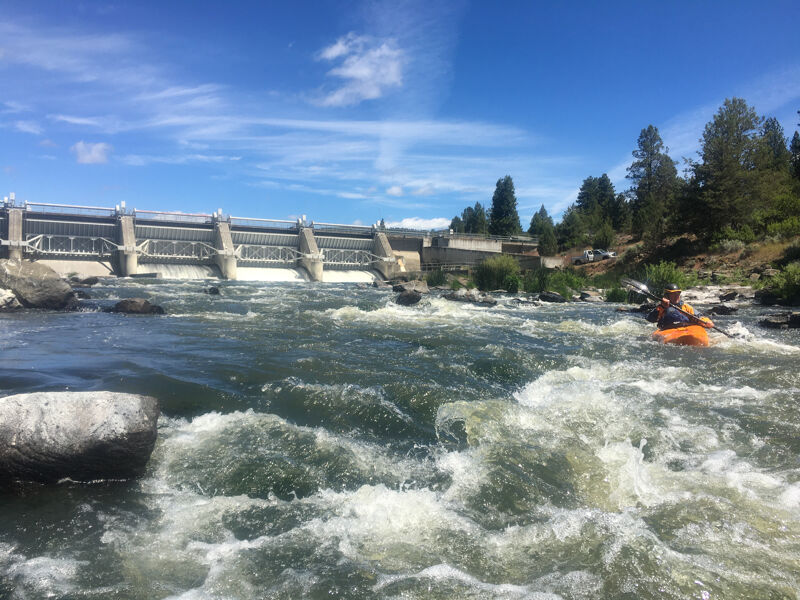
With Keno Park closed and no high clearance vehicle to access the Old Wagon Road, we drove to the start of the Old Wagon Road and hiked our boats out to the shoreline of the reservoir. From there it was about a half mile paddle to Keno Dam which we portaged on river right. We had 4300 cfs coming out of the dam but a good staging eddy on river right. The action starts right away but with no significant holes or hazards before the river settles into a calmer stretch just above Keno Play Wave. We cut right at the Keno Play Wave and found a good eddy on river right near the old powerplant.
Continuing downstream a decent-sized hole was hiding on river right and then we had another to pass on river left. The biggest hole on the river was just past the gage station and cableway where a very large raft-flipping hole extends 3/4 of the way across the river from the rock face on river left. It was relatively easy to skirt around to the right at this flow.
None of the rapid were especially difficult in this upper section although the action was continuous and the holes were a bit intimidating.
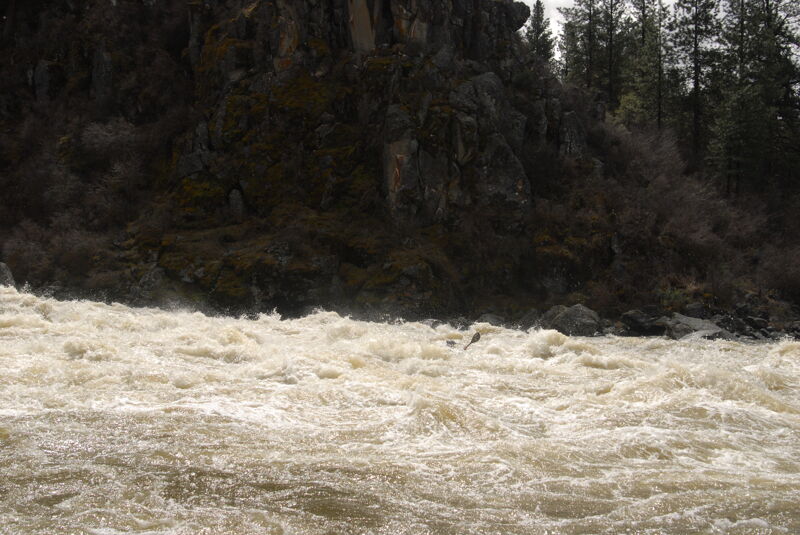
The action soon tapered off to bigwater class II and it was much more relaxed on the way down to Meatball. Meatball, recognized by the large meatball-shaped rock near the top of the rapid at center left, was the biggest rapid of the day but it is relatively short and you can see the calm pool at the bottom. I went down the right, crashing through a couple holes but nothing that stopped me, and others took a line to the left.
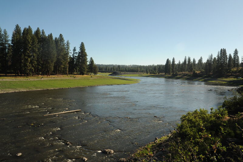
We were soon on the two mile flatwater paddle out to the Highway 66 Bridge with a lilttle bit of current to carry us along. We took out in the bridge right-of-way and parked on county property on the upstream river left side of the bridge.
Jun 11, 2024
We had an opportunity to enjoy the Keno reach of the Klamath River without the paddle out on the reservoir. We put in at Keno Dam on river right using a high-clearance vehicle to access the Old Wagon Road to reach this access point (the park and campground on river right is no longer being maintained by PacifiCorp and is inaccessible by vehicle as agencies determine future plans fort the site). The flow we experienced of 735 cfs is below an acceptable flow, as determined in the Final Whitewater Boating Study conducted as part of the enviromental review for dam removal. The first rapid immediately below Keno Dam was particularly challenging to navigate. After that it was possible to navigate down the river although more water would have been preferable. Once we reached Meatball, the last signficant rapid where the river previously ended at the reservoir, the run transitioned to lower gradient but still had some curerent. There were no rapids in this section down to the take-out at Pioneer Park. We did encounter a family of otters on a newly-exposed rock on the segment of the former reservoir that is now a river. We took out within the bridge right-of-way as public access at Pioneer Park has yet to be constructed. We hope to see that access in place in 2025.
Jun 9, 2020
Warm, late spring day on the Keno Run as part of a whitewater boating flow study for the Klamath dam removal project. Warm water, not great water quality, but fun whitewater even at this low flow.
Jun 9, 2020
This trip was for purposes of a flow study conducted by Confluence Research, under the direction of Klamath River Renewal Corporation, as part of an effort to quantify instream flow needs for recreation and impacts of dam removal on existing and future recreational opportunities on the river.
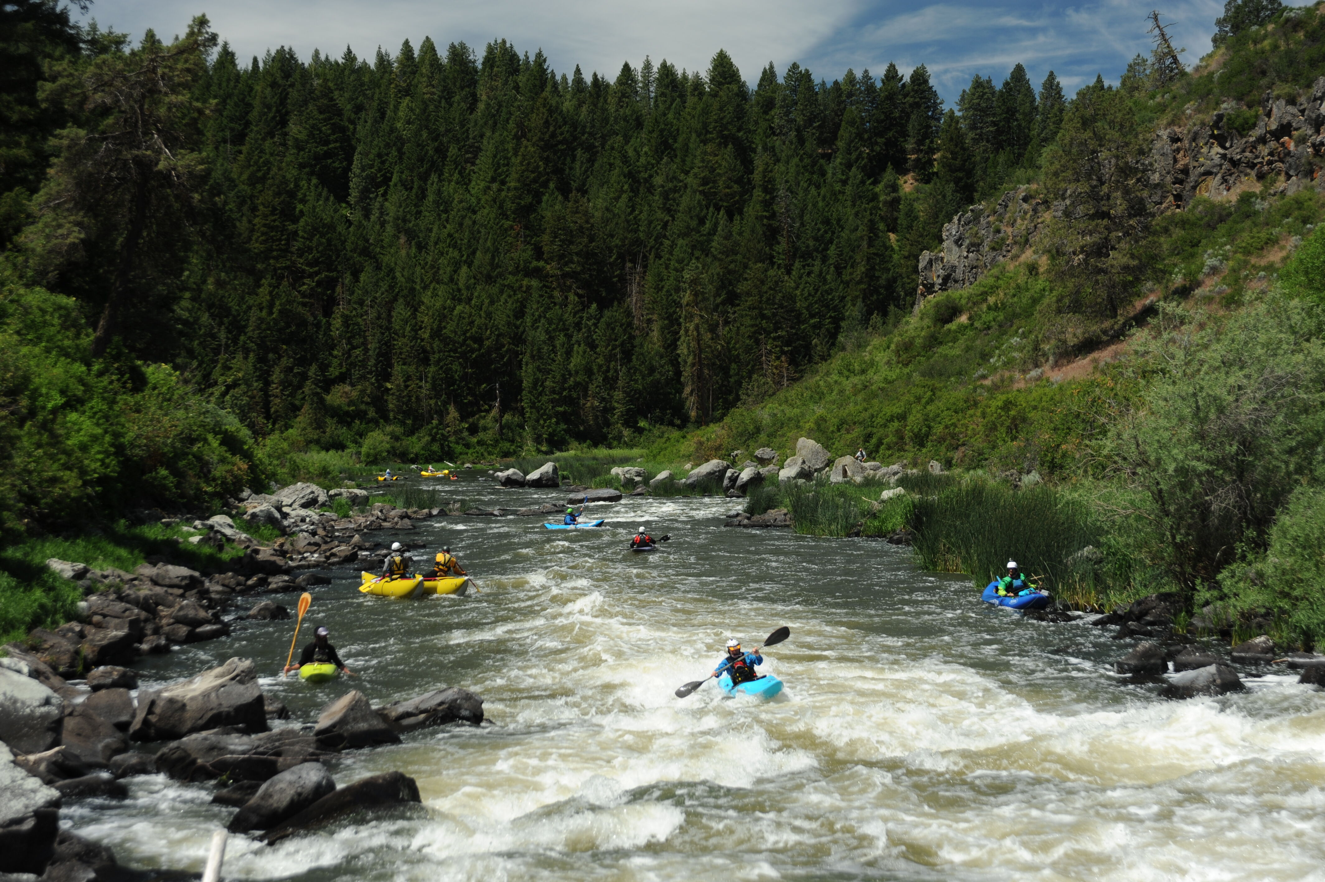
A flow of 800 cfs was evaluated which is in the range of anticipated flows in late spring and early summer associated with the Proposted Action of dam removal. At the Whitewater Boater Study flow of 800 cfs below Keno Dam, the study found that the segment’s Class II/III rapids are well-suited for hard shell kayak trips, particularly instructional trips for beginners or intermediates. Varied features and abundant eddies provide excellent opportunities for skill building. A flow of 800 cfs in the segment offers marginal opportunities for outfitted trips, particularly in larger rafts. Few rapids have strong hydraulics or large waves, and several reaches have shallow boulder gardens that produce multiple hits and stops for lightly loaded rafts. Although some outfitters considered this flow and segment suitable for challenging inflatable kayaking among clients with more experience, others were less sure about demand for or risks of such trips. Several rapids require more than a single move to avoid obstacles and linking several moves in a complex rapid is challenging for less experienced boaters. Outfitters thought such trips would need safety set-ups at key locations to provide directions, physically redirect boats, or retrieve people or boats in case of mishaps.
Boaters considered the 800 cfs study flow close to the low end of the boatable range. Although some suggested 500 cfs can be boated in a two-person raft, hard shell kayak, or inflatable kayak, the challenge and pace of the trip would be marginal. Major problems include the first half mile below the dam and the lower two-thirds of the segment, which have wide and rocky channels that would produce multiple hits and stops even with constant vigilance. Boaters reported that flows in Keno occasionally drop several hundred cfs within a single day, which further limits the potential for outfitted trips. Trips at 800 cfs are already marginal; a drop of 200 cfs could leave some craft high and dry in shallower reaches.
Mar 18, 2011
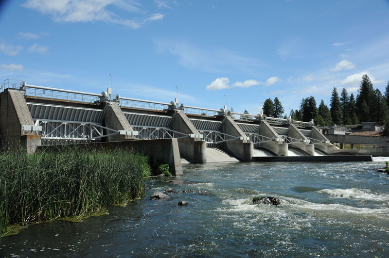
This run has one of the best surf waves around...'The Keno Wave'. When the Klamath at Keno gauge reads 1,150 to 1,400cfs it's good...darn good! It can still be surfed at 1,050 but it's quite a bit smaller and weaker. No need to do the run, you can drive right to the wave if you have a high clearance vehicle. Not that the run isn't worth doing a time or two, but that's about it. Me? I just park at the wave. To find the wave or the put-in for the run; head east out of Keno, cross the Klamath, Take the second left past the bridge, Puckett Way, then make the next left, Riveredge Rd. Follow Riveredge for a mile or so to Old Wagon Rd. were you'll make a left. From here to the wave a high clearance vehicle may be necessary. (Keno Reservoir will be to your left) At all intersections stay to the left , the road dead ends just above the wave. If you plan on doing the run put-in below the dam. For those with passenger cars, you can reach the south bank just above Keno dam by driving into the Keno Recreation site provided by PP&L, it's just west of downtown Keno to your right if headed west on Hi-way 66. The water quality here is not for the faint of heart, that being said this part of the Klamath sports some of the biggest rainbow trout I have ever seen.
Oct 22, 2009
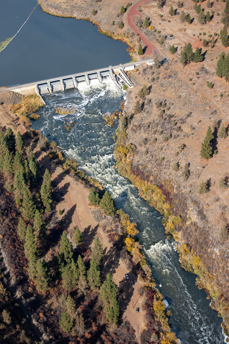
Aerial views of Keno Dam and the river downstream of the dam on the Keno Run. I shot these in October 2009 as part of Klamath Riverkeeper's advocacy work for Klamath dam removal and water quality improvements.