Puyallup
2 - Kapowsin Road Bridge to Highway 162
| Difficulty | II |
| Length | 8.1 mi |
| Avg Gradient | 28 fpm |
| Gauge | Puyallup River at Puyallup, Wa |
| Flow Rate as of 28 minutes | 1730 cfsbelow recommended |
| Reach Info Last Updated | June 10, 2021 |
The Puyallup River drainages includes the White, Carbon, and Puyallup Rivers which originate off the slopes of Mt. Rainier, Washington’s tallest mountain. All of these rivers offer whitewater boating opportunities that serve a range of skill levels form beginners to experts. White River The White River flows off the [...]Read More
FUN FACT: Good beginner river, few good short runs of rapids, scenic.
SEASON: Winter rains and warm spring melt from Puyallup Glacier on Mt. Rainier.
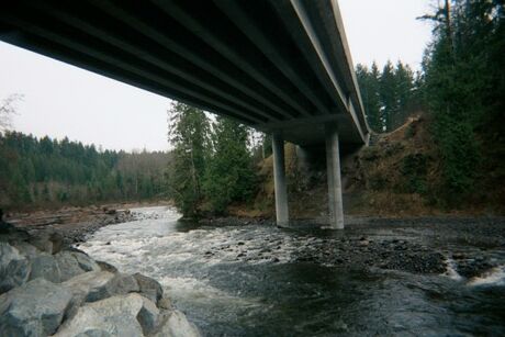
PUT-IN: From Hwy. 410 take the Sumner/Orting exit (Hwy 162 east) and continue on 162 through the town of Orting. Upon leaving Orting you will travel approximately 1.5 miles to Orville Rd. (Kapowsin Hwy.) Turn right and continue for approximately 3.5 miles to Kapowsin bridge (shown above). Parking to unload will be on the left before crossing bridge. Down over a small embankment will put you on a nice sand bar. This is an easy access. There is a cool curve at this point in a solid rock wall you can do if you portage upstream slightly. There's a neat rapid here that will get a beginner pumped up for trip.
TAKEOUT: Upon getting on Hwy. 162 east from Hwy.410 on the way to the put-in you will travel approximately 4 miles to an iron bridge that crosses the Puyallup. Parking will be to the right before crossing the bridge. You will see the access to the river at this point. It's a easy one and with a sand bar.
ALT.4.5 MILE TAKEOUT: Upon entering Orting on 162 East you will turn right on Calistoga St. and go approximately half a mile to a concrete bridge. Turn to the left before crossing the bridge into a large parking area. River is at view from this point. Nice take out, slight embankment.
RIVER DESCRIPTION: Good beginner river. Nice mix of class II rapids and flatwater. Most of the islands in the river can be run river right. A few areas have foliage of trees hanging down but can be paddled around easily and some make for some nice shade on hot days. The run can be easily boat scouted for wood or other hazards. If you enjoy this run, you might also like the lower carbon river run, which confluences into the puyallup just downstream from the take out.
Lat/Longitude data are approximate.
Park on East shoulder in a pull out just before the bridge. Descend a short trail to a graded platform adjacent to the river.
Pull off the river on the East bank before passing under the twin bridges. Climb the embankment and follow a gravel service road to the parking lot at the McMillin trailhead.