Planter Creek
A) Hwy.28 to Wertanen Rd (0.15-0.96 miles)
| Difficulty | III-IV |
| Length | 0.7 mi |
| Avg Gradient | 120 fpm |
| Reach Info Last Updated | April 4, 2022 |
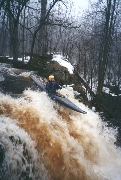
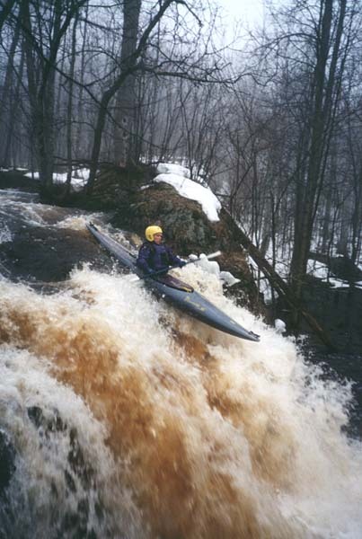
This is largely a 'Stupid Boater Tricks' run: short, sweet, tight and technical. For many boaters, the 'main event' will be Cashew Falls, but those not 'up' for it may put in below to run the next short but 'action' stretch.
The following video shows a pair of sit-on-top paddlers on that lower part of the run at what appears to be a pretty stout (banks-full) flow!
(Note: I've started the video at 1:57 as they actually put-in. If you replay after first watch, it will start at beginning , as they walk the full reach, do some 'logging', and set shuttle.)
(This is a clickable link:) https://youtu.be/MdxCesNIL7w?t=117

This is a rather odd situation. Besides the immediately surrounding topography, the only inflow to Sunday Lake is the upper part of the Little Black River, which also flows out of the West end of the lake. However, at the NorthEast corner of the lake, there is a spillway into an culvert which tunnels underground 0.3 miles, where it emerges from the hillside along Hwy.28 immediately before passing under the highway.
Because of this 'dual outlet' to Sunday Lake, it is extremely difficult to predict the conditions under which to find adequate flow in Planter Creek. Suffice to say, there has to be a LOT of water around!
Some paddlers may put in below this for the run-out action.
It is highly likely you will want/need to end your run at or before this point. The next stretch of the river is exceedingly likely to be so snagged up as to make paddling inadvisable (or unbearable). While there appears to still be decent gradient, there are no 'big' falls like the couple in the first quarter-mile (+/-).
While road maps show Wertanen Road crossing the river, aerial view shows that it does NOT. It is a dead-end road (essentially a driveway for a couple properties). This may be (at least part of) the reason the next bit of road is labeled Lagoon Road.