| Difficulty | III-IV |
| Length | 4.1 mi |
| Avg Gradient | 33 fpm |
| Gauge | Little Walnut Ck at Georgian Dr, Austin, Tx |
| Flow Rate as of 26 minutes | 99 cfsbelow recommended |
| Reach Info Last Updated | May 3, 2021 |
River Description
Little Walnut Creek has traditionally been described as the 'steepest urban creek in Texas', although that is not technically true (Wells Branch, a popular 1/2-mile feeder run into Walnut Creek, Little Walnut's cousin to the north, is steeper.) However, Little Walnut is still about three times as steep (on average) as the most popular stretch of Walnut Creek, and about twice as steep as the most popular stretch of Barton Creek, so 'steepest urban creek run in Texas longer than a mile' is probably an accurate description.
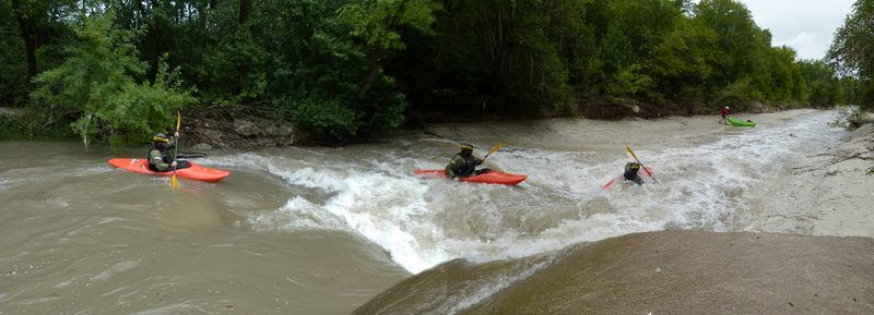
From a whitewater paddler's point of view, the name 'Little Walnut Creek' is a misnomer. It is every bit as wide as Walnut Creek, but the gradient makes it pushier, more technical, and more continuous. The gradient remains consistent throughout the run, with basically no flat water. Paddlers must usually catch eddies in order to rest. Eddies are generally filled with trash, the water quality is generally poor, but don't let that deter you. Little Walnut is a quality whitewater run that is unlike anything else in Central Texas.
There are only three named rapids, as of this writing, but those are named primarily because they stand out relative to the other rapids. There are numerous other rapids between them. The rapids are generally formed by natural limestone shelves and, between Cameron Rd. and U.S. 290, by a combination of natural limestone and a concrete conduit for a sewer line that runs along the creek bottom. There are few boulders or other natural obstacles in the main flow of the creek, so the rapids tend to be slidey with large waves (some as tall as 4-5') and reactionaries, few holes, and generally straightforward lines. However, the continuous-- and usually shallow-- nature of the creek makes it a bad place for a swim. In several places, the main flow leads into thick strainers. Numerous Class III -- and, depending on the flow, a few Class III+ or IV -- moves will be required in order to safely navigate the cree
...River Features
I-35 Bridges
Access PointDistance: 0 mi

'Texas Whitewater' suggested parking at the San Francisco Steakhouse (which is now a Chinese buffet, as of this writing) on the downstream river left side of the bridges and putting in at the print shop (which is now a Lumber Liquidators, as of this writing.) However, parking and putting in on private property without permission is never recommended, especially given the political realities of urban whitewater boating in modern-day Austin.
Boaters wishing to put in at I-35 can park along Hermitage Drive next to the vacant lots (the lots are at the corner of Hermitage and the frontage road), or they can park along Park Plaza Drive north of the creek and portage up to the put-in. Many choose to put in at North Acres Neighborhood Park less than 1/2 mile downstream, as this cuts out only one rapid.
North Acres Neighborhood Park
Access PointDistance: 0.43 mi
The pedestrian bridge over the creek provides easy access from both Hermitage Drive and Park Plaza Drive, both of which have street parking (parking along Hermitage Dr. is more limited.) Many paddlers choose to put in here for a shorter run, since it only cuts out one rapid.
The pedestrian bridge also allows for visual scouting of the rapid just downstream.
North Acres Rapid
OtherClass: IVDistance: 0.44 mi
At lower flows (< 500), this feature is just a small ledge wave. At higher flows, a limestone shelf and concrete wall downstream back up the flow from the ledge and cause it to form a retentive, river-wide hydraulic. The hydraulic has a nasty-looking pocket at river right, but running river left sets you up for strainers downstream. A trail on the south side of the creek (river right, downstream of the pedestrian bridge) allows for easily portaging the feature or putting in below it (at the confluence of a small feeder creek.)
The hole is known to be in at about 800-2000 cfs. Behavior at higher flows is unknown.
Cameron Rd. Bridge
PlayspotDistance: 1.07 mi
At 500-1000 cfs, a small surf wave forms next to one of the bridge pilings. Behavior at other levels is unknown.
The Slide
OtherClass: IIIDistance: 1.31 mi
Concrete buttresses on either side of the creek mark the location of the former 14-foot dam described in 'Texas Whitewater'. The dam was destroyed during the Memorial Day 2015 floods, and the remnants of it were apparently removed from the creek bed in the 2015-2016 timeframe. However, the slide (which is more like hundreds of yards long-- not the 100-foot-long feature that 'Texas Whitewater' describes) is still there, and it's the highlight of the run. At 500 cfs or less, it is boney. At 500-1000 cfs, paddlers describe it as being reminiscent of Gonzo Shoals on the Ocoee, but with more gradient.
Those Aren't Pillows!
OtherClass: III+Distance: 2 mi
A large, slanted limestone shelf at river right, about 100 yards upstream of the U.S. 183 bridges, constricts most of the flow into a one-boat-wide, steep trench at river left. The trench culminates in a head-high hydraulic that requires a shoulder boof at 500-1000 cfs. Behavior at other levels is unknown.
River-Wide Sewer Pipe
PortageHazardDistance: 2.68 mi
Known sieve hazard at < 1000 cfs, becoming more dangerous as the flow drops toward 500 cfs. Behavior at higher flows is unknown. Portage using the limestone shelf at river right.
Dottie Jordan Neighborhood Park
Access PointDistance: 3.64 mi
Many paddlers choose to take out here, since there is a large parking lot and 1/4 mile of public river frontage. This takeout also allows for a quicker shuttle and a shorter run, which is important if the creek is dropping rapidly.
After the Loyola Lane bridge, start looking for the fence at river left, past the tennis courts and just past the pool, and take out in the next convenient eddy. A path follows the fence back to the parking lot.
Manor Rd. Bridge
Access PointDistance: 4.1 mi
Last viable takeout, as of this writing. Street parking is available on the south side of the creek (river right, upstream of the bridge) along Lakeside Drive or Carol Ann Drive.
Trip Reports
Log in to add a reportNC
Nate Clark
May 19, 2021
CAUTION: DANGEROUS POUROVER AT HIGH WATER. There is a low head dam/pourover structure somewhere between mile 1 and 3 that formed a river-wide terminal hydraulic at 14,000 CFS that still looked very sticky at 8,000 CFS on our second lap. at 14k CFS there were no eddies or places to stop and we barely managed a one-boat-width sneak line on the right seam. At 8,000 CFS we were able to stop on the right-hand-side shelf at the top of the drop. I would not run this blind above 8,000 CFS.