Eno
1. Lawrence Rd. (Route 1561) to Pleasant Green Access (Route 1567)
| Difficulty | I-III |
| Length | 7.3 mi |
| Avg Gradient | n/a |
| Gauge | Eno River at Hillsborough, Nc |
| Flow Rate as of 46 minutes | 1.55 ftbelow recommended |
| Reach Info Last Updated | December 12, 2025 |
DESCRIPTION:
The first half of the run (roughly) extends from the put in to the suspended wooden footbridge (known locally as The Swinging Bridge) at the Fews Ford access of the Eno Park System. There are I's, II's and a III in this section. Soon after passing under the second set of power lines is Frank's Ledge. It is best to run it just left of center. Then, about a quarter mile upstream of The Swinging Bridge is Cabe's Ford Ledge on river left. Look for where the hiking trail dips down to the river's edge and the wooden walkways and steps along the cliffs on the left side. You can easily get out and climb the steps to scout the rapid which is about a 3' spillover at levels of 2.5' - 3'.
In the second half of the run, the river calms considerably with nothing above an easy II. The last mile or so of paddling before the take out is on flat water.
The Eno River Association web site (http://www.enoriver.org/eno/canoeing.htm) describes this section as 2 trips.
Trip 1 (take out at Fews Ford): 'There are a lot of minor rapids, 2 moderate ones, and an advanced rapid just before the Take Out. It should be scouted before running. It is best to run it at the slick and stay on the left of the rock. Historic points include the ruins of Berry's Public Mill, Holden's Mill and the site of Few's Mill.'
Trip 2 (from Fews Ford to Pleasant Green): 'This is a novice section. It is mostly flat water with a few small rapids at the beginning. Within a hundred feet above the old non-existent dam, Stoney Creek enters from the right. This is a scenic site with a series of waterfalls resembling a mountain stream. The climb along this creek is interesting and rewarding. It is accessible from the large parking lot at this Take Out.'
There are descriptions of other sections of the Eno River and links to maps on the Association's web site as well.
Directions to Take Out a
...Apr 12, 2013
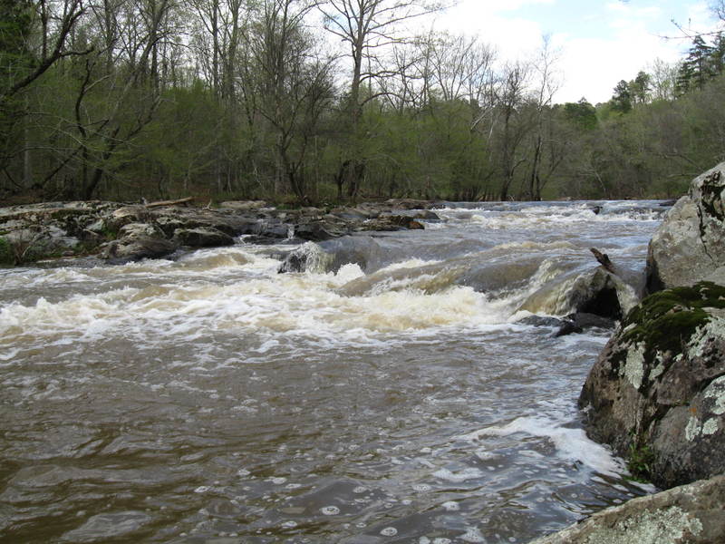
This is lower drop of the rapid at Cabe's Ford ledge. It is just upstream from the footbridge/swinging bridge on river left. It's easily scouted from the trail that runs alongside it. This drop is best run in the center, you don't want to get pushed too far right or left. The USGS gauge downstream@ the Colemill road bridge was at 3.43' when this photo was taken. At this level the rapid is a solid class III, and fairly technical. Scout and use caution.
Apr 12, 2013
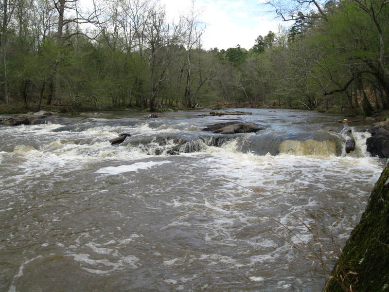
This is the upper drop of the rapid@ Cabe's Ford Ledge. The easiest line is far left, though this drop can be run center at this level. If you enter from the center you will need to do a quick S-turn before hitting the lower drop in order to avoid being jammed up in the rocks to the right. The USGS gauge downstream@ Colemill road was at 3.43' when this photo was taken. At this level the rapid is a solid class III, and fairly technical. Scout and use caution.