Kinnickinnic (Milwaukee trib)
S.20th Street to S.5th Court (1.8 miles) *Access&Quality Issues*
| Difficulty | II+(IV) |
| Length | 1.7 mi |
| Avg Gradient | n/a |
| Gauge | Kinnickinnic River @ S. 11th Street @ Milwaukee,wi |
| Flow Rate as of 41 minutes | 4 cfsbelow recommended |
| Reach Info Last Updated | March 28, 2025 |
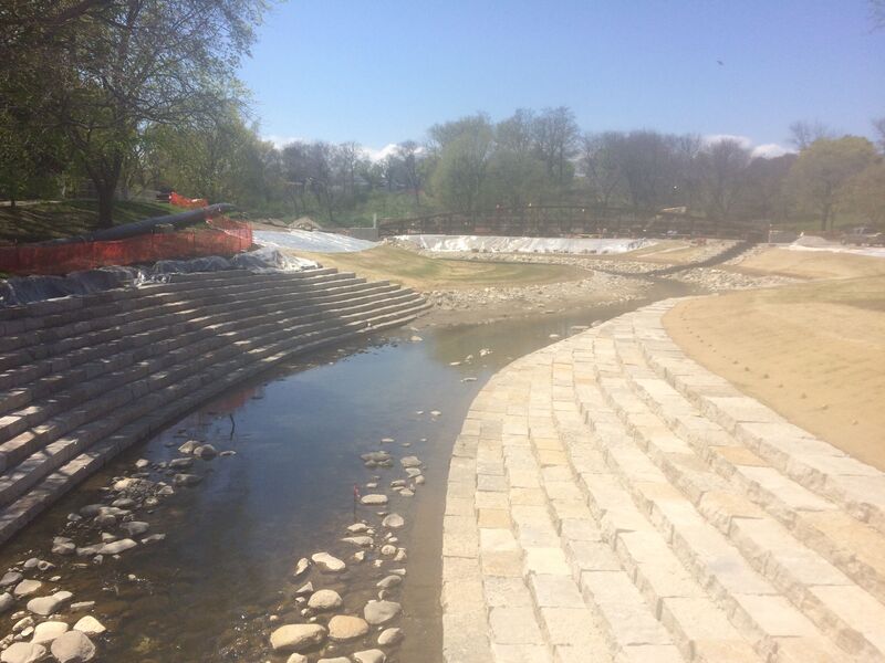
MMSD (Milwaukee Metropolitan Sewerage District) will be spending tens of millions of dollars, removing concrete, widening to re-create a floodplain, and meandering the channel (where possible) to alleviate flooding and improve fish and wildlife habitat.
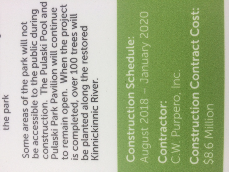
From Cleveland Avenue to 16th Street (through Pulaski Park) was completed early 2020.Similar work is planned downstream, from 16th Street to 6th Street, which will eliminate two of the three 'jumps' detailed below. The timeframe for that phase has not been announced (as of 2023) but will keep our eyes and ears open to update this once this moves forward.
Click the following video link in which MMSD officials speak regarding plans for the lower stretch of this river. At 0:54 and 1:48 views (briefly) of the cement-ditch/river at high-water are shown.
=======================================================================================================================================
This description is being included to DISSUADE anyone from thinking they have discovered some unknown or unrun bit of whitewater. Much of this river has been altered (straightened, smooth-curved, and cemented) for the convenience of mankind, allowing roads and subdivisions to be laid out less hampered by the randomness of nature. At a few locations, 'hydraulic jumps' (cement ledge/drops) exist. With good flow, these may look like interesting whitewater, however, they will form wicked hydraulics at some flows!
You need to scout every drop prior to putting in (I.E., while you are setting shuttle). Once on the water, getting out to scout or portage may be difficult because there are virtually no eddies in this uniform cement ditch! Even more problematic, flow changes extremely quickly during and immediately after rains, making it impossible to know precisely what conditions would prevail by the time you w
...
vvvvvvvvvvvvvvvvvvvvvvvvvvvvvvvvvvvvvvvvvvvvvvvvvvvvvvvvvvvvvvvvvvvvvvvvvvvvvvvvvvvvvvvvvvvvvvvvvvvvvvvvvvvvvvvvvvvvvvvvvvvvvvvvvvvvvvvvvvvvvvvvvvvvvvvvvvvvvvv
If the descriptions (above and below) are not enough to dissuade you from considering this run, you might wish to be further informed . . .
The following quotes (with emphasis added) are from an article (in the Shepherd Express, a local 'alternative' newsweekly) entitled 'Going with the Flow -- How the suburbs are helping close the beaches':
'Tests during rainfalls ... at 15 sites along waterways in Milwaukee County regularly show E.coli and fecal coliform amounts are thousands of times higher than the EPA standards for beach closings ...'
'... numbers this high are comparable to untreated sewage.'
'One study found ... about 15% of fecal coliform found in stormwater runoff is from dogs.' (I.E., people who do not pick up after their pets!)
'The highest concentrations of E.coli and fecal coliform have been found in Underwood Creek in Wauwatosa and in the Little Menomonee River'
'people can get sick from water like that, but the illness may be passed off as something else since it isn't that severe.'
So . . . take all that for what you wish to make of it!
^^^^^^^^^^^^^^^^^^^^^^^^^^^^^^^^^^^^^^^^^^^^^^^^^^^^^^^^^^^^^^^^^^^^^^^^^^^^^^^^^^^^^^^^^^^^^^^^^^^^^^^^^^^^^^^^^^^^^^^^^^^^^^^^^^^^^^^^^^^^^^^^^^^^^^^^^^^^^^^
PLEASE TAKE NOTE: the 'Mile' markers on these early features are NEGATIVE, to indicate that they are NOT part of our recommended run. They are being included primarily as warning for anyone who may think of exploring further upstream.
Technically, this is apparently a tributary called Lyons Park Creek. The flow comes out of a long (and, I believe, grated/non-enterable from the top end) tunnel. There is virtually no reasonable 'staging area' from which to launch into this cement ditch, and the police department has posted signs prohibiting entry into the cement ditch.
There are a few interesting looking jumps in the next 0.4 mile. Even if it weren't prohibited, it would be quite difficult to find flows at the 'goldilocks' range: not too low (totally scrapey), not too high (washed-out and impossible to get out of), but 'just right'.
A step-drop of ~3-4' immediately precedes ~295' of cement-box culvert. As you approach this box culvert, the combination of the drop and the low ceiling of the culvert will look like the river just disappears (or that it would decapitate you!) at any boatable flow.
As the cement ditch leaves the box culvert, it drops down two hydraulic jumps in quick succession and then begins nearly a mile of non-cement (more 'natural') streambed, surrounded by trees. This stretch is HEAVILY prone to deadfall and impassible snags. Only the ignorant or most masochistic of individuals would attempt to paddle this mess!
Convenient parking (to look at the 'roller dam' and to hike in to the 5.5' corrugated iron-wall dam) is available just off S.43rd Street. For the best viewing, park in the south end of the lot. (The north end would be very close for the iron-dam, but you'll be on the wrong side of the river for the best and easiest viewing locations.)
The 'Roller-dam' is immediately adjacent (right under the downstream side of the 43rd Street bridge), while the Iron-wall-dam requires crossing the river (via 43rd Street bridge or a footbridge just downriver in the park), then walking along the edge of the woods near the river until a VERY OBVIOUS path into the woods which will take you right to the 'falls'.
Immediately under the downstream edge of 43rd Street lies a rounded cement slab ('hydraulic jump'). With high flows this is likely to form a very uniform hydraulic. However, with only 2.5 square miles drainage, it will seldom get high flows, and they won't last very long.
Upstream of this point, the heavily wooded area is extremely prone to deadfall and snags, so putting in above this location is extremely unlikely by anyone who has bothered to read this description or to look at the actual river!
After 43rd Street, the river passes under a pedestrian bridge and turns sharply to the left (to head north for a short distance) before encountering a railroad embankment where it again turns to the east. Anyone foolhardy enough to be in the river is advised to get out and scout before rounding that bend.
Almost immediately around the bend is about a 5.5' vertical corrugated-iron-wall drop. River-left of the landing pool, two culverts under the railroad contribute flow of '43rd Street Ditch' (a 2.3 sq.mi. tributary, nearly equal the KK at this point), which may cause some interesting currents at times of high flow.
It looks like it could be fun just to carry in to run this drop ('doing laps'), but with such tiny drainage area, getting here when it has the right flow would be exceedingly rare. However (having looked at this once at relatively high flows), flow 'backwaters' so much here that the pool height nearly eliminates all of the drop! So, you'd need 'goldilocks' flows: enough water to not totally scrape coming into/over the edge, but not so much water that the pool height all but eliminates the drop.
While we have seen no specific plans, it seems likely this 'jump' will be removed as part of the MMSD projects affecting both the KK and the 43rd Street Ditch.
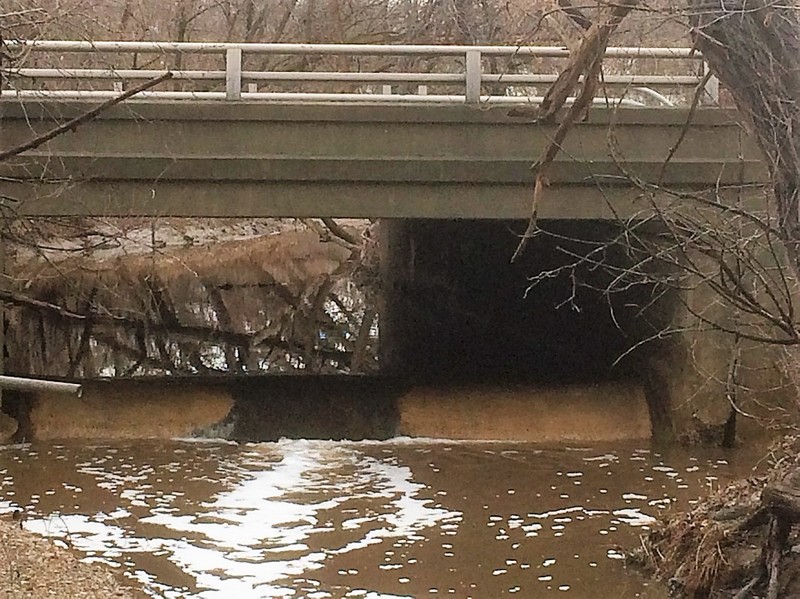
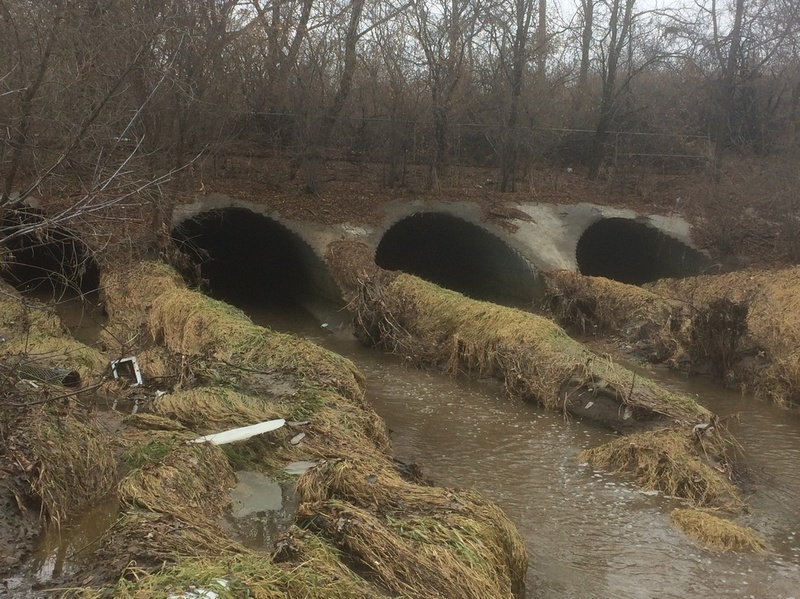
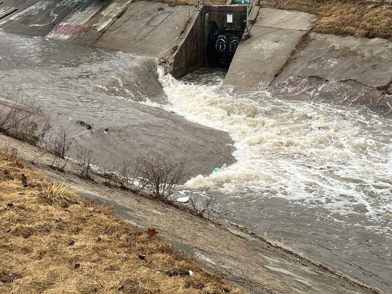
The river enters four ~7-8' diameter culverts for ~656'. A right-bend midway through means you won't see 'the light at the end of the tunnel' (until after that bend)!
Nearly a mile of heavily wooded banks upstream are very subject to deadfall, so wood accumulates here, hanging surprisingly high on these culverts, potentially precluding entering ANY of the culverts. The county (or some entity) occasionally clears wood from this location. However, it would be possible for wood to hang up within them, making entering any of them (in a boat) an extremely risky proposition. Even if passage were possible, each boater would need a bright water-resistant flashlight/headlamp to navigate the tunnels! Also, it would be nearly mandatory (before entering the tunnels) to go ashore and walk to the end of the culverts to scout there. (See next description for more info on that.)
This is scheduled to be 'daylighted' (removal of culverts). MMSD website says 'Construction on the riverbed is expected to begin in 2026'
Until that happens, significant skills may be needed to get ashore (in the cement trough prior to the culverts), to exit your boat, and to portage (bushwhacking through the woods) to the downstream end of the culverts.
Coming out of the culverts, flow is initially separated by high dirt/grass berms. It is entirely possible that wood which does not hang-up on the culvert entrances could (upon exiting the culverts) become lodged between the earth berms. It would be irresponsible and risky to enter any of the four culverts (if/when passage is even possible) without first having checked the exit of these tunnels to be certain you aren't heading into certain disaster. (Kind of like playing russian roulette ... four culverts, staring (paddling) down one of them, not knowing whether it's 'loaded'.)
NOTE: MMSD (Milwaukee Metropolitan Sewerage District) has plans to 'daylight' the river (I.E., remove these culverts), and create some meanders and broader floodplain through here. Timelines have not been published as yet.
Almost immediately after passing under the Kinnickinnic Parkway Road, an overflow stream from the lake/pond in Jackson Park cascades down a narrow cement sluiceway, tripping down a couple of stepped/pools on its way. (No, there's virtually no chance at all that this stepped sluice would ever be boatable. It's merely a minor 'scenic sidenote' to the river.)
The MMSD project (by my understanding) will dredge and enlarge the pond, and divert some of the flow of the river into it (as a 'detention pond'). It is possible/likely that this falls (or another replacement overflow accommodation) may then return some of that water back into the main channel.
Access is possible from S.31st & W.Manitoba, under a footbridge just before the confluence with Wilson Creek.
OR ... you could carry over to put on from the cement shoulders on Wilson Creek (coming out from under St.Lukes after being underground for a good while), to run a quick little chute into the KK.
The downside of this put-in ... there is NOTHING of interest for nearly a mile ... you're in a cement ditch with a lot of shrub willow and a lot of urban trash.
So ... look further down for the better choice put-in.
Immediately after our listed (theoretical) put-in, Wilson Creek enters river-right. It has 3-4 times the drainage area as the Kinnickinnic above this point, but is considered a tributary!
Some may wonder: if Wilson is that large, why not boat it! Well, before this confluence, it is underground for about a quarter-mile! Its an open cement ditch for ~0.35 miles, then there's another nearly 0.2 miles in a box-culvert (under Point Loomis Shopping Center). Go up another 2.6 miles and its underground again (from Layton to Howell, coming out of the north end of Mitchell field. By the way, entrance to this culvert is grated/gated, so you would have to portage! The vast majority of the above-ground portion of Wilson is uniform sides and bottom cement ditch with no significant features (no pourovers or 'jumps').
Parking (for the Kinnickinnic Sports Center) is available just off S.20th Street.
This lot cuts off nearly a mile of featureless flush, and leads more directly to what action there is on the KK.
HOWEVER ... it is above the next feature, which is potentially the most problematic spot on this run!

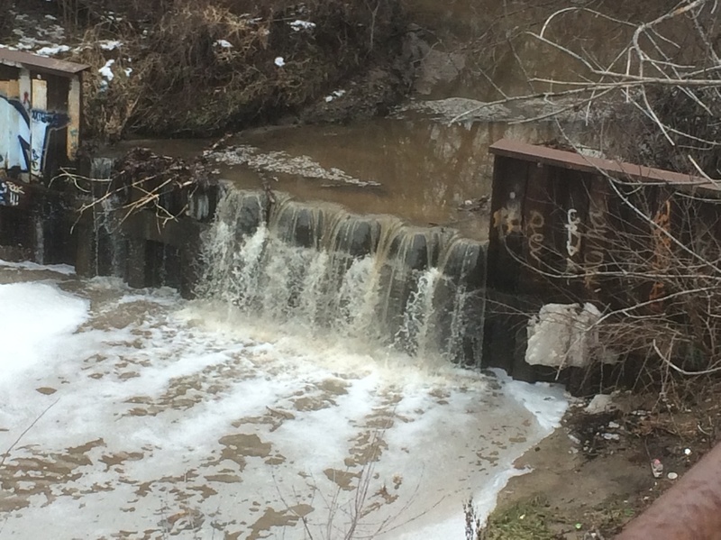
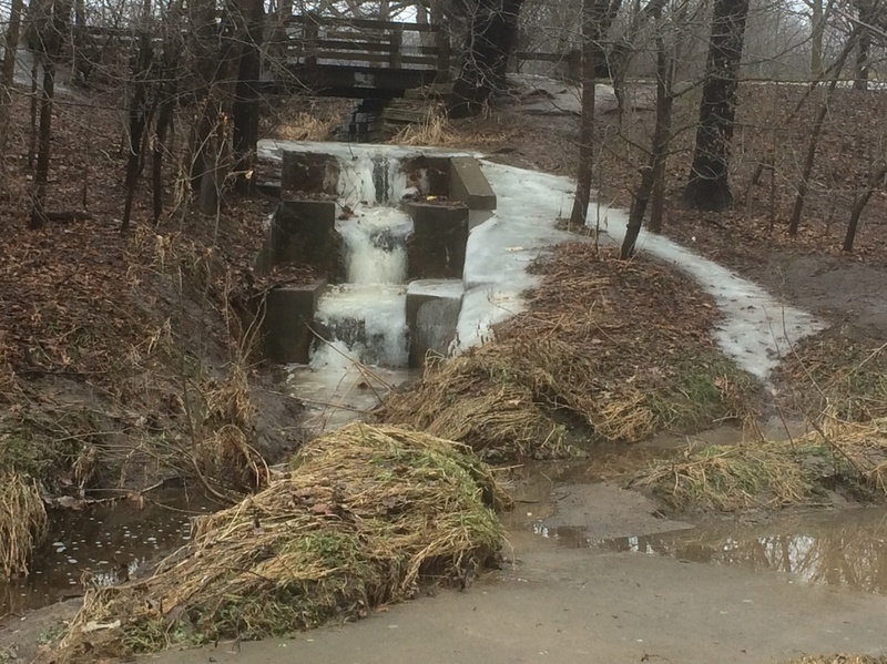
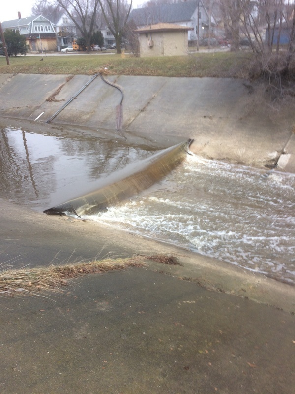
A quarter-mile past S.20th Street, beyond a roundhouse left bend (to head northerly) lies a very wide roughly 3' jump.
At 145 cfs, the approach (from around the bend above this jump) is totally scrapey, but the jump is clean to launch a 'boof' down the middle.
Above 400-500 cfs, the reversal may be inescapable in your boat.
The river is not that deep (at most reasonable flows), so you may be able to stand up in the backwash, grab your boat, and walk to shore! (Anywhere else on the run, extremely swift current in the uniform cement ditch will make any attempts to stand and walk in the stream very dangerous to nearly impossible!)
The problem is ... when on river, there is virually NO WAY TO GET OUT OF YOUR BOAT TO SCOUT unless flow is low enough that you can 'grunge out' near shore on the approach to this feature! Therefore ...
Before putting on upstream, this feature should be scouted by parking on S.16th Street just south of the bridge over the railroad tracks. Step over the guardrail, carefully make your way down (and back up) a steep heavily-wooded slope to get a view from as near water level as you can. Analyze the reversal / backwash and carefully assess your chances of being able to run this drop and not be stuck in the reversal. That said, by the time you finish shuttle, put in, and arrive here in your boat, conditions will almost certainly have changed!
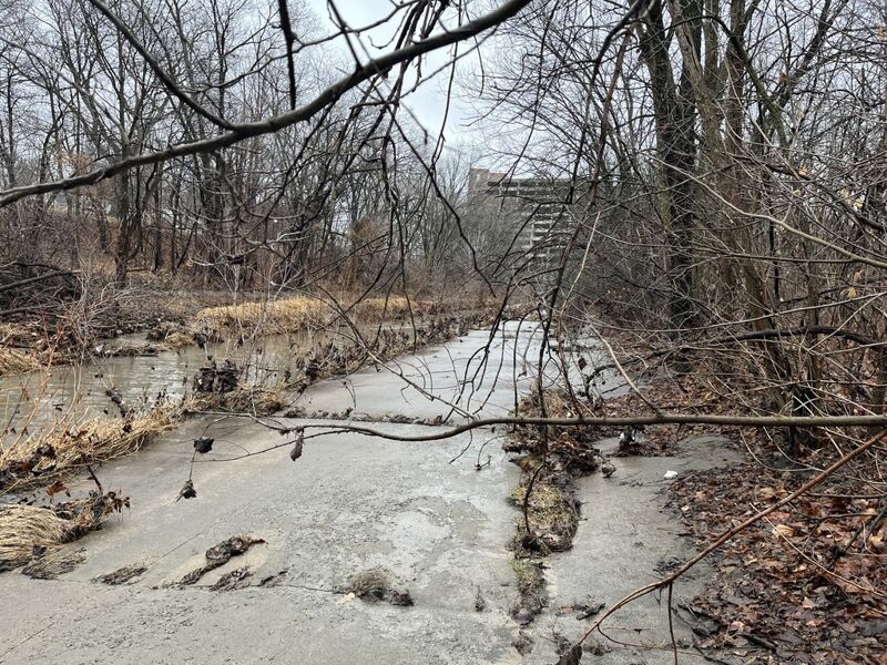
As the river comes out from under the (active) railroad lines, it encounters an area which has been 'remediated' by MMSD. Due to extremely flashy high flows, there is still a need to armor the banks with quarried rock (as shown here) to reduce/prevent major shoreline erosion and damage.
To create 'rills and pools' and to reduce streambed erosion, these 'remediated streambeds' are peppered with massive boulders, entirely atypical of any natural streams in southern Wisconsin. These boulders in the streambed create danger of foot-entrapment (as well as making it brutal for bumps, bruises, and possible broken bones) for anyone in the water out of a boat. Fortunately, in this stretch, the boulders do not populate the entire streambed, and gradient is relatively minor, so such risks may be minimized a bit.
Nonetheless, if in the water and out of a boat, do not try to stand in the stream if currents are strong! Keep feet up, and swim to shore in an eddy (if you can find one) before trying to stand and get out of the water.
From 16th Street to 6th Street the river resumes being a concrete ditch. MMSD (Milwaukee Metropolitan Sewerage District) has plans to strip out that cement, lay back the banks to create a floodplain, and use rocks in centerflow to create 'rills and pools'. Shores will have walkways, benches, and new plantings to make this into a neighborhood parkway. Timeline says this should happen in 2025.
It is likely (as in other such projects) that they will build a cofferdam and pump water through pipes to bypass the channel while they do this work. It will be necessary to scout this area to see when that project begins, and determine whether the river is passable during that work.
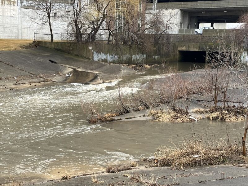
After passing under S.13th Street (you'll see a pedestrian bridge crossing where S.11th Street dead ends either side of the river), a short 'hydraulic jump' will be encountered. This one is very minor, formed by what look essentially like parking-lot stop-blocks in the cement-ditch-bottom. At flows in the 400-600 cfs range, this forms a sweet-looking V-wave which could allow catch-on-the-fly one-shot surfs.
Visible from a footbridge spanning the cement ditch at 8th Street (which dead-ends on each side of the river), this hydraulic jump is quite interesting. As shown in the photo, the right side stays high further than the left side. All faces are sloped rather than vertical, making for some VERY interesting currents here.
Also, immediately at the base of the drop, on the left, there is an storm sewer (combined sewer) outlet which could (at times of excessive rains) contribute significant contaminated flows.
Anyone considering putting in upstream of this point should stop here first to have a look at this feature. At flows around 300-400, left-of-center has a wicked looking wrapping wave, while the right-side drops into a fairly significant reversal. It will take significant skills to avoid being violently flipped by the strong currents! (A 'power nasal flush' of stormwater is likely to ensue.)
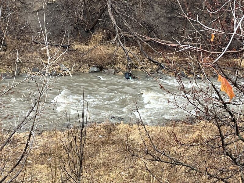
As the river comes out from under 6th Street, it leaves the cement behind and runs through ~1000' which have been 'remediated' (shores laid back and 'armored' with rocks in the stream, and quarried rock on the banks).
At low water, this will be 0.2 mile of class I-II rock dodging. At 600 cfs (and likely any higher flows), it's largely just a splishy-splash wave train (nothing playable). Some in-between flows may be slightly more interesting.
Until additional cement is removed and remediation is completed upstream, the best option for this river may be to just park and play this area ... other than ...there is an apparent homeless encampment under the 6th Street bridge (along with signs of numerous other encampments along this river). Be prepared to deal with the dirty underbelly of urban environments. Perhaps once remediation is complete from 16th to 6th, and the area is turned into a more family-friendly park-like setting, the homeless will be forced elsewhere, and this may become a more reasonable destination for (tame) whitewater boating.
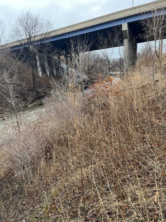
As soon as you are under the upstream edge of the interstate (high overhead), gradient has run out and you are largely at Lake Michgan water level. Riverbed turns largely to mud, and banks are quite steep, mud/dirt to the left, rocks and dense shrub cover (largely buckthorn) to the right.
Best choice will be to exit IMMEDIATELY, using the river-right eddy under the leading edge of the freeway bridge. Carry upstream just a bit (to a storm sewer outfall), and head upslope to the end of a fence along the sidewalk.
Street parking does not seem available on Rosedale Avenue, but is available on S.5th Court.
So ... after all the above ... until further remediation is completed ... this would be the most recommended start and end ... to just Park-and-Play (PnP) this final 0.2 mile of this river.
Mar 5, 2025
Scouting this section at marginal/minimal boatable flow of 145 cfs.
Nov 14, 2018
As shown by the on-site signage, this work has a planned cost of $8.6 Million! (And, far as I can tell, that is just for the initial brief phase within Pulaski Park ... there is a next phase for similar work from 16th Street down to 6th Street.)
Nov 14, 2018
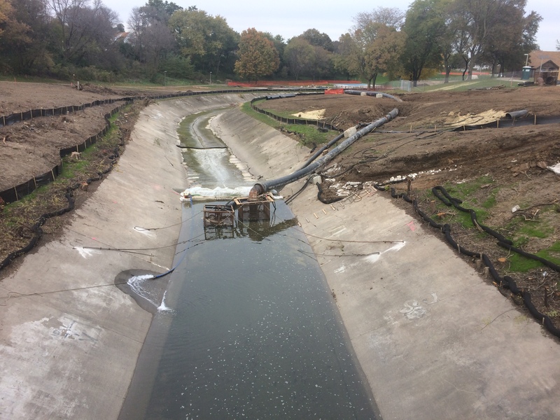
As of Autumn, 2018, work has begun to remove cement from a stretch of river in Pulaski Park. A very short cofferdam pools the usual/normal flow to allow pumps to put all flow into pipes on shore to bypass the riverbed, allowing heavy equipment to work in the channel.