Monatiquot
Shaw's to Weymouth Landing

| Difficulty | II-III |
| Length | 3.9 mi |
| Avg Gradient | n/a |
| Gauge | Monatiquot River at East Braintree, Ma |
| Flow Rate as of 1 hour | 3 cfsbelow recommended |
| Reach Info Last Updated | May 23, 2018 |
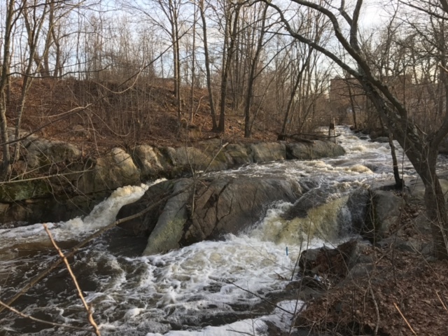
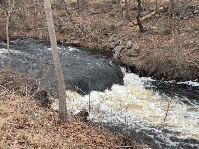
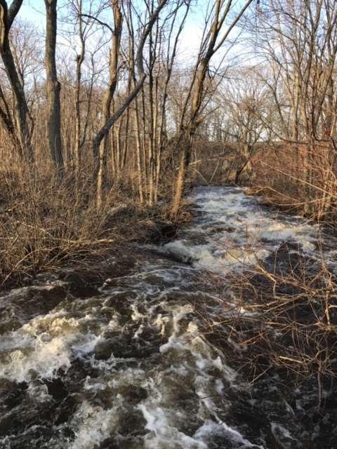
The Monatiquot river takes a 5 mile course through the city of Braintree as it makes it way to the ocean at Weymouth Landing. The river has 3 distinct rapids located at the Put-in, Mckusker Drive, and Shaw Street separated by lots of flatwater and narrow class I-II. Where the river flows out of Hollingsworth Pond near the Braintree RMV is where the first real rapid is. There is an old mill that obstructs driving directly to the put-in, so access is a bit tricky, however there are plans being made to removal the mill which may improve things in the future. Park behind Shaw’s or The Chateau and hike up over the railroad tracks up river right to put-in above the first rapid. This rapid is the best feature of the run and would warrant park and huck laps given the amount of flatwater after it. It is a fairly straightforward 100 yards of class III with 2 options left or right with 3-4 foot drops at the end. This rapid requires the most water compared to other features on the run and you should look for >200 cfs to run it, however could be scraped down as low as 170 or so. From here you’ll go under the railroad through an old stone bridge where the river flows behind Shaw’s through a narrow wooded area consisting of fast moving class I-II, however be on the lookout for river wide trees and over hanging brush given the constricted nature of the run and fast moving current.
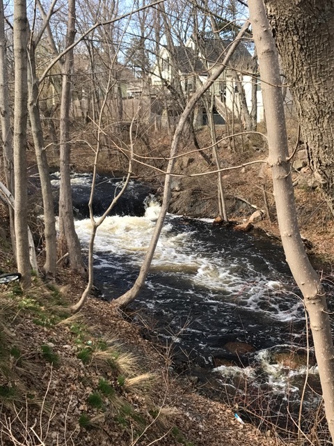
Once the river goes under John Mahar Highway it is meandering flatwater that takes you through marshlands under route 3 and runs adjacent to route 3 on the east side for a while. As you approach the River Street Bridge current picks up and is back to class I-II boogie water. You’ll pass under a railroad bridge and the Middle Street overpass, however the first Adams Street Bridge directly after Middle Street is too low to clear so plan to portage. The other dozen or so bridges you pass under all have plenty of room with normal runnable flows. Moving downstream is more flatwater and intermit
...Mar 15, 2026
A warm week after a snowy January and February had the Monatiquot over the 200cfs mark this week. We couldn't run it until Sunday when it was lower (around 130cfs) but it was still a fun little paddle. We took on the river in our 16' Dagger Dimension, which is probably a little bigger than optimal for the Monatiquot, but it did the trick.
We put in right behind Shaw's, just upriver of the bridge at the back of the parking lot (https://maps.app.goo.gl/V1rrwimdGiGSPSDx6). There is a sign there for the Monatiquot River Nature Trail, which we followed a short ways upriver to check out the put-in rapid. We ended up putting in at the tail end of the rapid, which looked a little gnarly at the lower water level. The feature shown at 0:54 in https://youtu.be/ksPs7zTQ3OU?t=54 had pretty much no flow on river left at 130cfs, but the parts upriver might have been runnable if we weren't a little nervous, having not touched paddles since last summer.
This section (and many downstream sections) were also pretty overgrown with overhanging brush and some sticks and logs across some or most of the river. In our whole trip there was only one spot where we actually had to portage/drag the canoe over a blockage, but there were several spots where we were hunched over pushing through sometimes-thorny branches that blocked the river.
Final note about the put-in and accompanying rapid is that the mill referenced in the river description, and its associated dam, appear to have been removed and there is a new fish ladder and what looks like a little viewing platform. From Google Maps it looks like there is a new boardwalk in progress on the left bank of the river accessible from Plain Street (https://maps.app.goo.gl/R9yUtD4LRhAZQnut8) which would probably provide great scouting and river access.
After the swiftwater tail of the first rapid, there is a decent chunk of wooded flatwater. Route 3 and trash are constant reminders that you're not exactly in the wilderness but it's still a nice float down to the more exciting last bits of the river.
The second paragraph of the river description does a pretty good job describing the transition to swiftwater and the Mckusker Drive and Shaw Street rapids. We actually were just barely able to squeeze under the Adams Street bridge that the description references as being too low, but I imagine that at higher water levels that would be impossible. It's also worth noting that there are some pipes under the bridge that make it even lower than it initially appears.
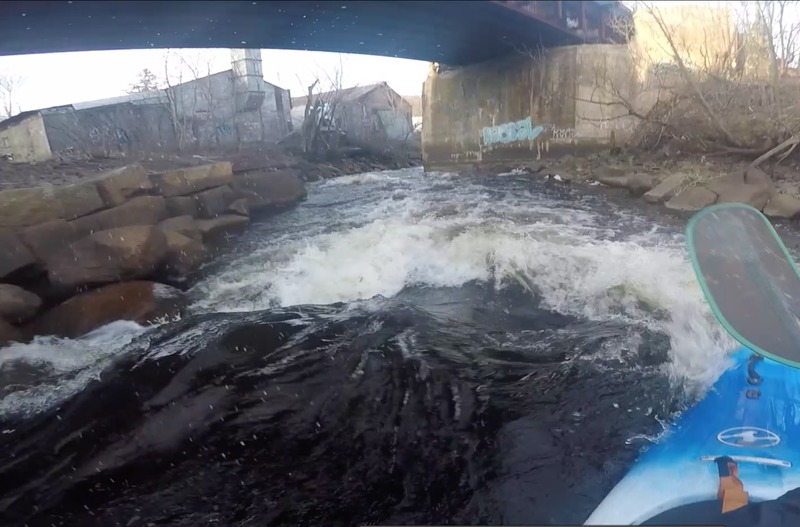
We scouted both of the bigger rapids on river right, which required a little bit of scrambing and ducking under the railroad bridge in the case of the Shaw Street rapid, but it wasn't too bad. Accumulated debris was a bit of a factor in the Mckusker Drive rapid, blocking all but the right-most channel under the bridge at 2:59 in https://youtu.be/ksPs7zTQ3OU?t=179. We hit the Shaw Street rapid just after low tide, which was fun, but the ending was a little bit of a rock garden at such a low water level.
After the rapids, a short paddle took us to our take-out at the Weymouth-Fore River Canoe Access boat ramp (https://maps.app.goo.gl/YuzTEogKEcz72MjVA). While a bit of sun would have been nice, the Monatiquot definitely satisfied our itch to get back out on the whitewater!