Suamico
CTH.M to Fireman's Park/Deerfield Lane (PnP, 5.73 miles, or up to 8 miles)

| Difficulty | I-II |
| Length | 5.3 mi |
| Avg Gradient | 8 fpm |
| Gauge | Duck Creek Near Howard, Wi |
| Flow Rate as of 41 minutes | 7 cfsbelow recommended |
| Reach Info Last Updated | April 24, 2025 |
Quick Facts:
Location: EastCentral Wisconsin, ~4 miles WNW from Suamico, ~10 miles NNW from Green Bay.
Shuttle Length/DriveTIme: 4.1 miles/7 minutes.
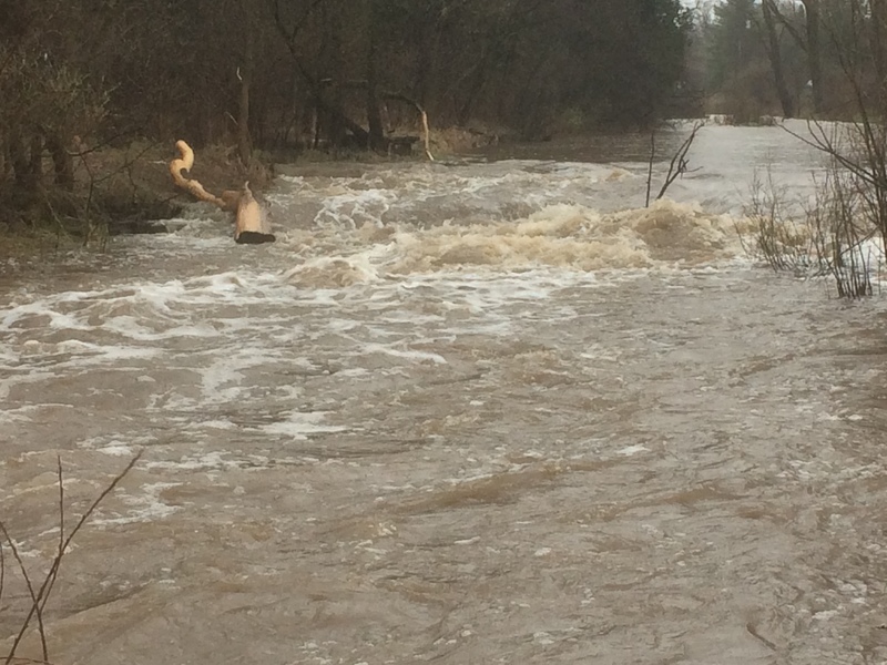
Character: Mostly flat/flowing water, interrupted by occasional shoals, swiftwater, and minor rapids, with one notable brief bedrock drop.
Put-in elevation is approximately 635'.
Take-out elevation is approximately 585'.
Thus total elevation change is approximately 50'.
Drainage area at our listed put-in is approximately 52.2 sq.mi. (via USGS StreamStats software). By our listed take-out, it has increased to 66.5 square miles (27% increase).
The listed 'full run' is primarily for recreational paddlers looking for a longer stretch of river. Those looking for whitewater will likely do the initial half-mile (or less). Midway along this portion is a brief bedrock intrusion which can form an interesting wave. A gravelled pull-off immediately adjacent allows scouting or PnP (Park and Play) at this spot. This is unlikely to be a major destination for many paddlers, but can provide entertainment for those in the Green Bay area.
After the initial half-mile of this run, there will be numerous areas of shoals, swiftwater, and light rapids punctuating the flat/flowing water to our listed take-out.
There are also areas of gradient for about 1.6 miles upstream of our listed put-in. Unfortunately, the next public access on the main stem of the Suamico is ~6.3 river-miles upstream of our listed put-in. (It is unclear from aerial views whether there are any significant features, or if the river manages to lose this gradient without encountering any rock/bedrock, and thus without true rapids.) Alternative access on the North Branch is much shorter accsss paddle (with some nice gradient as well), but is likely quite narrow and prone to deadfall and snags.

To have a chance to explore the steepest gradient apparent on this river, the nearest available access point is on the North Branch of the Suamico.
Unfortunately, the final 1.25 miles of the North Branch meanders though heavily wooded area and may be more portaging than paddling.
However, once you reach the confluence with the main Suamico, it should be less prone to wood, and you will be on the ~1.5 miles leading into the put-in listed below. From aerial views, it is not apparent whether the river actually has any good features in this stretch ... it could fritter away the gradient without encountering any true rapids.
Very near the intersection of School Lane and Pine Lane, with a small gravelled area adjacent, a bedrock intrusion creates an anomoly in this otherwise relatively flatwater/swiftwater river. At some flows, there may be some play possible here.
This sports bar and grill (on river-left) has a footbridge across the river to a ball diamond (on the river-right). With appropriate permission obtained (and likely with patronage for post-boating food and/or beverage), you may be able to park here, use restrooms, and facilitate just doing 'laps' on the first half-mile+ of this run.
A short trip (with the best of the swiftwater / whitewater) could take-out here. However, parking and access may be problematic, as this is in the midst of a residential area. Likely it will be better to continue to other listed options.
Access appears reasonable at this crossing. There may be some areas of gradient downstream, but it may have increased problems with deadfall.
Moreover, it is four miles to Lake Michigan (as the crow flies ... likely 5 miles or more by river), and there is only 20 feet of drop, so only 4FPM overall.
Access is likely to be contested right at this road crossing. (Both sides of the river, upstream and downstream of the road) are private property.
There is parkland (Weed Mill Park) accessable from Rockbottom Court, but it appears to be an undeveloped/unimproved area in the midst of a subdivision. (Oddly, topo maps show three ponds in this area, but aerial views show only a grassy open area.)
In very quick succession you encounter three bridges ... this is the first.
... this is the second ... (it is not just a side street, it is Side Street)
Immediately after Side Street, you'll pass under a railroad bridge, and Suamico Fireman's Park is just downstream on river right. (A village of Suamico fire station is diagonally across the nearby intersection.) There is an improved landing (for paddlecraft), a portajohn, a picnic table, and parking for 6 cars, plus two cars with trailers, plus a handicap spot.