| Difficulty | I-III |
| Length | 11.6 mi |
| Avg Gradient | n/a |
| Gauge | East River Below Cement Creek Nr Crested Butte, Co |
| Flow Rate as of 1 hour | 59 cfsbelow recommended |
| Reach Info Last Updated | January 13, 2019 |
Projects
Colorado Forest Planning (CO)
Forest Planning in Colorado American Whitewater is closely involved with Colorado’s National Forest Planning efforts. Nearly 68% of Colorado’s forests are Federally owned and managed as public land by the Forest Service (USFS) (47%), Bureau of Land Management (BLM) (17%), and the National Park Service (NPS) (2%) (CSU, 2018) [...]Read More
River Description
We are looking for more information on this run. If you have paddled this stretch before and have photos or beta on flows, please comment below or send an email to kestrel@americanwhitewater.org. Thank you!
Getting There
The Lower East River runs from Crested Butte South to the small town of Almont, where it converges with the Taylor River to create the mighty Gunnison. This entire reach is roughly 12 miles long, with an optional takeout after 7.5 miles at the Roaring Judy Fish Hatchery (River Left). To get to the take out drive north on Highway 135 from Gunnison and look out for signs indicating the Almont River Access Area, which is located just downstream of Almont and the Taylor - East River confluence. Roaring Judy Fish Hatchery is just a few more miles up the highway on the left. Access for the put in can be found at the Crested Butte South Wastewater Treatment Plant, just off of Highway 135. Access at the Treatment Plant has been very sensitive in the past, so please respect any signage and clean up after yourselves.
River Character
The Lower East River has a very different character than the classic creeking run upstream. The river ranges from class I to III and at higher water (~2,000) it can provide fun wave trains and good surf waves with a bedrock nature. This whole stretch is roadside (Hwy 135), but is quite scenic, nonetheless. As the river gets closer to Almont beware of increasing amounts of wood, especially as the river starts to split into numerous braids. Wood can be frequent and unsuspecting, so be aware before you go.
Access Issues
There have been alerts of multiple barbed wire fences to avoid along this stretch. Location, height, and severity of barbed wire will depend on season and flows. As of May 2018 there were no reports of barbed wire on this stretch, but be aware b
...River Features
Put In
Access PointDistance: 0 mi
Take Out
Access PointDistance: 12 mi
Trip Reports
Log in to add a reportKG
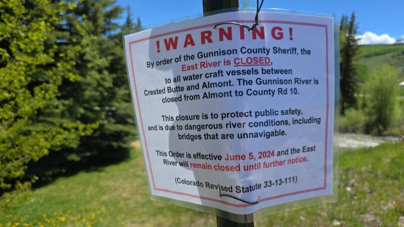
SECTION CLOSED JUNE 5TH BY GUNNISON COUNTY SHERIFF - Kevin Grooman
Jun 6, 2024
Signs posted at the put-in at Cement Creek Road.
It says the river is too dangerous and some of the bridges are unnavigable, see photo
DW
Dylan Wood
May 16, 2022
As of 5/15/22, there are no significant stainers or barbed wire that make this section unrunnable. There is, however, plenty of wood in the river to be avoided, the worst of which is between Roaring Judy and Almont.
At ~1350 CFS, this is a fun run with lots of wave trains and not many eddies. I don't see how you could run this stretch over ~1800 CFS in a raft, as the bridges are pretty low, though we saw a few ~13-foot rafts with frames make their way under the bridges just fine at ~1350.