| Difficulty | I-II |
| Length | 9.9 mi |
| Avg Gradient | 8 fpm |
| Gauge | Pine River Below Pine R Powerplant Nr Florence, Wi |
| Flow Rate as of 41 minutes | 1.91 ftbelow recommended |
| Reach Info Last Updated | January 27, 2025 |
River Description
With 80% of its length as flowing flatwater, this beautiful stretch of the Pine River is best considered as a way to add 1.3 miles of class 1-2 rapids to a trip from Hwy 55 by taking out at Hwy 139. Or, it could be a way to add some distance and a rapids onto a downriver trip by starting above Chipmunk Rapids. The whole trip from Stevens Lake Rd to Chipmunk Rapids takes about 4 hours.
The Pine River is a state of Wisconsin designated Wild River however, all of the public-owned riparian land along this section of the Pine is USFS land that is managed similar to but not the same as WI DNR managed land further downriver. Camping, continuously running artesian spring water, and pit-toilet are available at the USFS campground at Chipmunk Rapids.
River Features
Stevens Lake Rd. Put-in
Access PointDistance: 0 mi

Put-in is on river-left, upriver of the bridge. Parking is along the road only.
Stevens Creek Rapids
OtherClass: IIDistance: 1.4 mi
Near the end of this 1/3-mile long class 1-2 rapids is Stevens Creek on the left. An excellent tent camping spot is available at the confluence, on the upriver point of land.
Long Stretch of Minor Rapids
OtherClass: IDistance: 1.8 mi
This mile long, stretch of class 1 and swifts starts shortly after the end of Stevens Creek Rapids continues all the way to the Hwy 139 Bridge
Hwy 139
Access PointDistance: 2.7 mi
This optional takeout is on river-left just downriver from the bridge. Current is swift so be in place to make the eddy and avoid getting swept downriver. There is a parking area off the NE guardrail end of the bridge.
Swifts and Class 1 rapids continue for another 0.6 miles past the bridge.
Fay Lake Rd. Bridge
Access PointDistance: 4.3 mi
This is another optional takeout and a way to adjust trip length. Access is undeveloped but generally on river-left, upriver of the bridge. Parking is along the road.
Old Powers Dam Rd. Bridge Site
OtherDistance: 8 mi
1.4 miles above the start of Chipmunk Rapids. In 2019, a local effort will look at the potential to locate access (with short walk-in distance) in this area that would be on USFS land at 1.4 miles above the start of Chipmunk Rapids.
Chipmunk Rapids
OtherClass: IIDistance: 9.4 mi
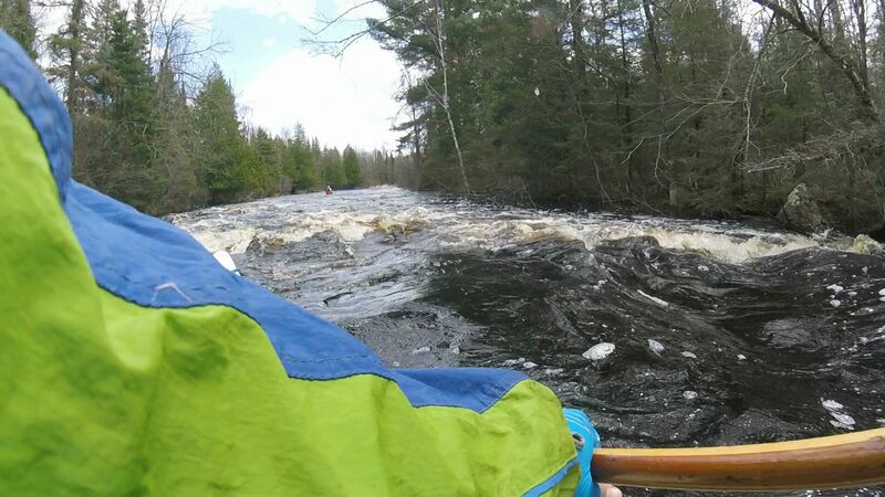
Two sets of class 2 rapids (higher water may decrease the need for maneuvering and lower the rapids to a fast, class 1). A small, close-to-river house on river-left signals the approach with rapids starting around the right turn. Land on both sides of the river along the first rapids is private. USFS land, on both sides, starts just after the end of the upper rapids.
Photo: Chipmunk Rapids (1520cfs at USGS flow station). Photo taken by John, 5/6/2018
Chipmunk Rapids Takeout
Access PointDistance: 10.1 mi
The landing is tucked in on river-right, 150 feet downriver from the bridge. There is a staff gauge mounted on the downriver, river-right side of the center bridge support (interpretation in tab on flow). 100 feet up the path to the parking lot is the continuously running artesian spring water. The USFS campground starts just to the left as you get to the parking lot. A pit-toilet building is available