| Difficulty | III+ |
| Length | 4.4 mi |
| Avg Gradient | n/a |
| Gauge | Nf Snoqualmie River Near Snoqualmie Falls, Wa |
| Flow Rate as of 1 hour | 68 cfsbelow recommended |
| Reach Info Last Updated | December 7, 2021 |
River Description
If you want something short and sweet that is mostly Class 2 then ends with several quality drops with great views, give this section a try. It also pairs nicely with a hike up to Sunday Lake for a full day of outdoor fun in the area (check wta.org for the Sunday Lake hike logistics).
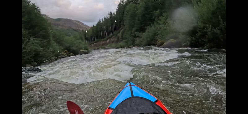
The run starts out on Sunday Creek. It will likely be boney but passable for the hundred yards to the NF confluence. There is a small stump right before the confluence that has been known to catch wood so give it a look beforehand. Once on the NF you can relax for the next 3 or so miles and enjoy the amazing views and easy read and run Class 2 drops. Some nice beaches in there for lunch and/or lingering if the weather is nice. The river will then begin to pick up the pace, and a cliff on the right wall with a lot of old slides will come into view. That is your queue for the first 3+ rapid. I would scout this drop first time down as it varies with flow and might have wood in one of the channels. At lower flows you can enter right and grab an eddy before the big drop which is river center. Not far past this drop is the biggest drop the run which could be Class 4 at higher flows. The run is left of center over a big double ledge. After clearing that you are entering the continuous Class 3 section that turns around a right corner and continues to the takeout bridge.
NOTE: Do not pass the takeout. Class V+ Big Creek Falls is just a couple hundred yards downstream of the bridge.
Logistics
To reach the river, head north on Ballarat Ave. in the town of North Bend (one block east of the main intersection in town). Just follow Ballarat Ave. which will bend to the right and become SE 108th St. and bend to the left where it becomes 428th. St. In 2.0 miles from the turn onto Ballarat you will cross the Middle Fork, in 2.4 miles you will cross the North Fork, and after 3.9 miles you will reach a Y and the turn for North Fork Road that heads up the hill to
...River Features
No river features have been added
Trip Reports
Log in to add a reportKK
Packrafted @1000 CFS - Kevin Kolbay
Aug 16, 2025
No issues getting down at this level, Majority of the river was Class II with the last 1 mile containing class III. 1 tree partially across 80% of the River, but was easily avoided. View from the takeout bridge gives a good indication of what the bottom rapids will look like.
AF
Andy Frazier
Dec 2, 2021
Do not miss the take out. Past the take out bridge is (approx. 200 yrds) a Class V+ drop, and is filled with wood as of 12.01.21. Do not make the same mistake I made, and intend to combine the upper and middle sections, and not know the location of this drop.