Wildcat Creek
W.Howard Ave. to Kulwicki Park (1.2-1.5 miles)('Stupid Boater Tricks')
| Difficulty | I-II |
| Length | 1.5 mi |
| Avg Gradient | 45 fpm |
| Gauge | Wilson Park Creek @ Gmia Outfall 7 @ Milwaukee,wi |
| Flow Rate as of 41 minutes | 0 cfsbelow recommended |
| Reach Info Last Updated | April 10, 2026 |
Quick Facts
Location: Greenfield (Milwaukee), WI.
Put-in: 42.97092 -88.06561 (4001 S.122nd Street)
Take-out: 42.9659, -88.0468 (Kulwicki Park)
Shuttle Length/DriveTIme: 1.3 miles/5 minutes Shuttle Route
Gradient: 45 FPM Ave, 55 FPM max mile.
Never rely on class/rating or gradient to decide if you should run a river/rapids!
More important are 'character factors' such as: (1) continuous versus pool/drop, (2) wide-channel with multiple routes versus narrow channel with just one route, (3) straight routes versus complex technical moves required routes, (4) gradual river banks versus rocky shores or steep-walled gorges, (5) heavily wooded (prone to strainers, sweepers, deadfall) versus shrubs, grasslands, or non-vegetated surroundings, et cetera.
Character: Extremely narrow, overhanging trees and shrubs, likely deadfall, minimal eddies and little chance for egress.
Typical width: 5-10 ft.
Drainage area at put- in: 1.1 sq.mi.
Drainage area at take-out: 1.9 sq.mi.
General Overview
This micro-creek will require significant rain to come up, and you'll likely have to arrive while it's still raining (or IMMEDIATELY after it stops) to have any shot at it having enough flow. Since the window of opportunity is so brief, you don't really want to take too much time scouting while it's runnable. Therefore, it is recommended that anyone thinking of trying this run should do visual recon just a day or two before predicted rains might make it runnable!
It's not whether there is wood, it's whether it is possible to get under/over/around the wood in your boat, or (if it must be portag
...
The N.E. corner at 124th and W.Howard Avenue is city owned. Best parking would be on 124th Street, but the creek is heavily wooded the short distance from there to Howard, so far better to put in on upstream side of Howard. Unfortunately, it may be tougher to find a way to park off the road close to the river on Howard.
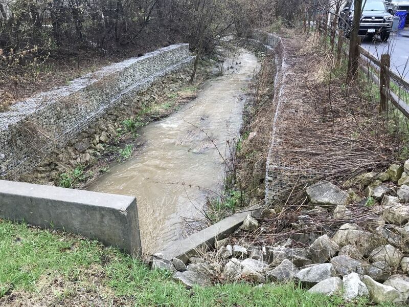
As shown in the photo, the downstream of Howard Avenue has streambanks 'armored' with gabion baskets (chain-link-fence boxes, filled with rocks), making it not very scenic, but confining the flow and (at least somewhat) diminishing the likelihood of strainers or blockages in the immediate downstream area (since there are not trees and shrubs on eroding banks).
A private footbridge downstream (just before the following/recommended access) should have adequate clearance at any reasonably boatable flow.
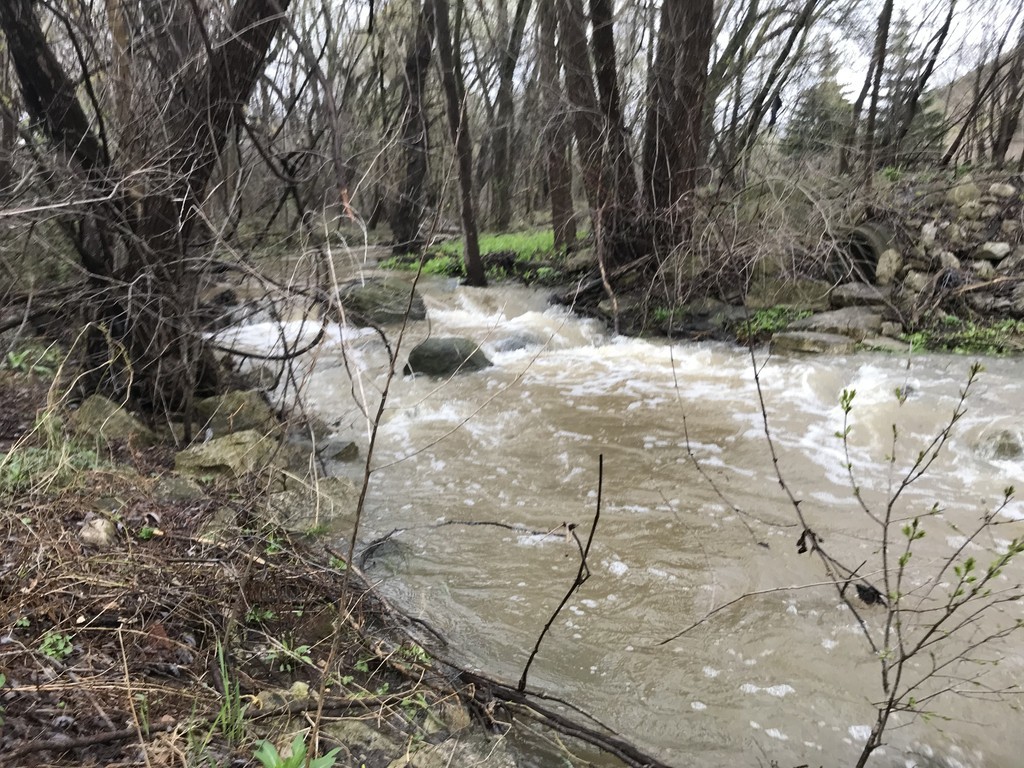
Just beyond that footbridge, as a tributary enters from the right, the first of a number of tight zig-zags occurs.
From the dead-end stub of 122nd Street, DO NOT WALK DUE NORTH TO THE CREEK! THAT IS PRIVATE PROPERTY! (Potential disputes regarding unmarked/indistict public vs private property are a reason for not listing this as primary put-in.)
A narrow City of Greenfield property flanks a paved path. At a fire hydrant (even with the back corner of a house), city property extends north to the confluence of a branch of the creek (adding nearly equal flow). From here to Beloit Road, most of the land along the creek is designated as 'Wildcat Creek Nature Corridor'.
A major zig-zag in this very narrow creek is very likely to catch wood, and (even lacking wood) will take significant skills to successfully navigate.
We highly recommend scouting this location before putting in at the upstream site! (And, since this location cuts off just over a quarter-mile of relatively uneventful flow, you might just as well put in here as you scout here.)
There is good clearance through a triple-box culvert, and swift currents lead in and out of the culvert.
Another triple-box culvert with plenty of clearance.
This large cement-box culvert has plenty of clearance (with the road passing well-overhead). A slight bend midway means you won't see the light at the end of the tunnel. Expect a bit of rocky rapids as you exit this ~75' long tunnel.
NOTE: It is highly recommended to scout this location before putting on. If there is any wood hung up above the culvert, or immediately downstream of the culvert, it would be very difficult to avoid or to get ashore to portage. Unfortunately, it is awkward to scout here. Best chance may be briefly parking on the shoulder of Beloit Road, then walking to where you can look at each side (the upstream and downstream, entrance and exit) of the tunnel.
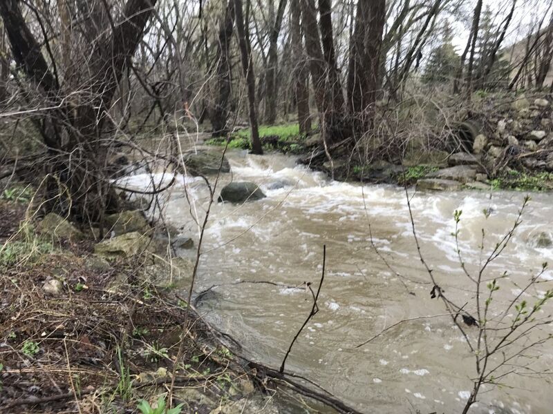
There's plenty of clearance under this pedestrian/bike bridge. However, a quick jig-jog just downstream is highly prone to snag wood. Proceed with caution!
The accumulation of wood which had blocked the zig-zag for a few years has been cut and cleared (as of spring, 2026). However, this spot is likely to accumulate more wood at any time, so ...
SCOUT THIS LOCATION BEFORE PUTTING ON!
The best way I know of to access this location (for scouting) is to park on 116th Street just south of Cold Spring Road, then walk (or bike) the Falcon Ridge Trail north of that intersection to get to this bridge.
Again, be aware that not far downstream of that zig-zag, virtually all the shoreland is private property until the take-out in Kulwicki Park.
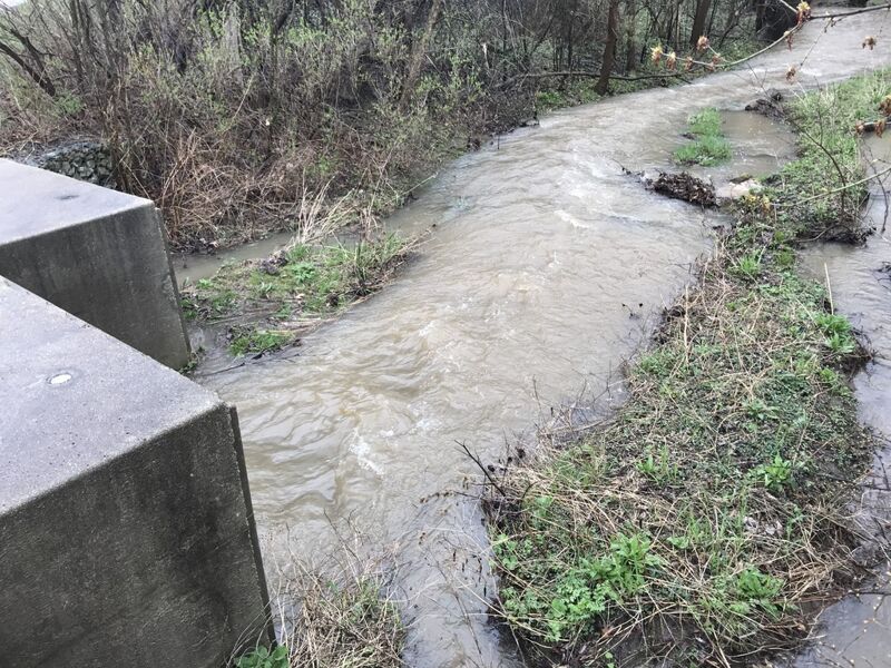
Mostly a waypoint ... plenty of clearance in the culvert. Oh, and just upstream (as pictured), possibly the most significant rapids on the whole run ... a very brief pitch at a boulder choke.
As an alternative to the listed take-out, some paddlers might find it more convenient to use a dead-end stub behind the Aldi's store. This is a (slightly) less 'visible' location (if you need to change into/out-of boating gear, or to stash a bike for self-support shuttle). It also cuts off the short narrow gabion-lined approach to Cold Spring Road, which has had branches and grape vines overhanging and possibly impeding passage.
Four houses/back-yards on your right and a wood-slat fence (high upshore) on your left precede a sharp right-hand bend. At this point, the left shore becomes gabion baskets (think chain-link-fence boxes filled with rock), leading to the culvert under W.Coldspring Road. There may be grapevines dangling from the trees on the right shore, but passage appears unhindered tight to river-left.
After the ~95' long Coldspring Road culvert, there is ~120' of 'daylight' before ~135' long 108th Street culvert.
Almost as soon as you clear the S.108th Street culvert, start looking for a good place (river-left) to land, exit your boat, and carry up to your 'drop vehicle(s)' in Kulwicki Park.
FWIW, right around the corner (at 4353 S.108th) is Organ Piper Pizza. They open 5pm T/W/Th, 4pm F/Sa/Su.
Music on the Wurlitzer Pipe Organ starts a half-hour after they open. It's quite an experience.
(There are menu options besides pizza, and they do have adult beverages: beer, wine, mixed drinks.)