Ashuelot
3. Lower Ash(Ashuelot to Hinsdale)
| Difficulty | II-IV |
| Length | 3.7 mi |
| Avg Gradient | 55 fpm |
| Gauge | Ashuelot River at Hinsdale, Nh |
| Flow Rate as of 56 minutes | 3.12 ftbelow recommended |
| Reach Info Last Updated | May 1, 2018 |
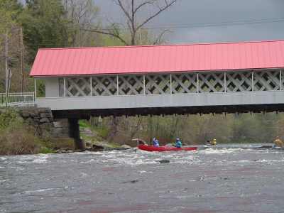
Put in elevation........430'Take out elevation......239'Total drop..............191'Average drop/mile.......55'Distance................3.5 milesRiver width average.....85'River water quality.....Poor to fair, water clarity fair.Scenery.................poor in spots, a few factories along the way.From Keene NH take NH route 10 south for approximately 13 miles. Take a right onto NH route 119. About 2 miles to the put in just upstream and river right from the Ashuelot covered bridge.
From Interstate 91 in Vermont take exit 2 onto route 9 into downtown Brattleboro. Take a right then follow the signs to NH 119. Follow NH 119 approximately 8 miles to the put in.
From the put in take NH 119 west 3.5 miles into downtown Hinsdale. Look for a small dirt parking area next to the river. The new owner of the warehouse at the take-out in Hinsdale is friendly to paddlers, but requests that we park head-in by the picknick table, so as not to block a truck backing into a dock at the rear of the building.
The river is broken up into three sections. Each section is seperated by a dam which must be portaged. The upper section is a nice warmup class II. The second gets a little more difficult... up to class III. The last section is the toughest...class III-IV depending on water level. The McGoldrick Dam was removed by the NH Department of Environmental Services in 2002 thereby eliminating one portage on the lower section.
Only two portages left since the other dams have either been washed out or removed. The first portage is between the Class II and III section. The second between the III and IV.
This river holds water very well since it is at the bottom of a huge watershed, it is usually one of the last rivers in New England to be running during the spring.
Video of the Ash at 5.3:
...This is a fine warmup. Put in just upstream of the Ashuelot covered bridge. The run from here is an easy class II for approximately 1.5 miles to the backwater of the first dam. There is a line across the river warning boaters to carry around a dam. Take out on river left by the sign and carry around the dam by the old factory. EDIT: The factory owner on river left doesn't want people trespassing; recommend portaging river right.
This section has a bit more challenging water. It is also shorter only about a half mile. The best rapid is just above the flatwater as you approach another factory on your left. Once again take out and carry on river left. The put in below the dam is rather steep and difficult among boulders. It helps to have two people to lower boats below.
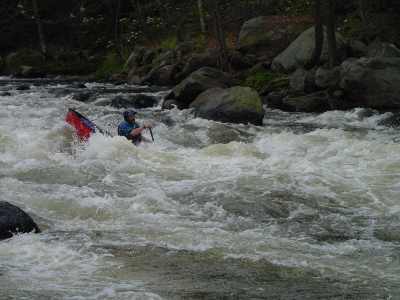
This is the toughest section of river on this trip. Just below the dam you will be passing a paper mill. There is a lot of trash in this area from that mill. Just below the factory bridge is the toughest rapid on the lower Ash. This is Papermill rapid. There is a rather clean straight line through this rapid just right of center. To the left is a series of holes that can swallow an open boat. The rest of this section is continuous class III+ water with little let up.
This section of the river can be easily scouted from the road on river right that you can pick up a mile or a mile and a half downriver from the put in, off of 119.
At 700 CFS (about 4.5 feet), this section is a 2+; at 1000 (4.9 feet), it is a good beginner's class 3. At 1500 cfs (5.35 ft), the river becomes much pushier. At this level, Paper Mill Rapid becomes a big water class 3+ to 4, depending on your rating system.
May 31, 2025
My group met Kieth, the owner of the first factory on river left that's normally used as the portage between the class 2 and class 3 sections. He was polite but told us he doesn't want people trespassing on his land. I'd recommend either portaging the first dam along the road on river right or just skipping the class 2 section below the covered bridge and putting on below the first dam on river right. It seemed like there was a great parking area there, but you'd probably have to bushwhack a hundred or so yards down to the river. (42°47'23.4'N 72°26'39.0'W)
Aug 7, 2009
This run is one of my favorite park and play runs. It has two major play spots that are awesome for intermediate to advanced play boaters. May I add they are both loopable. The first hole is very retentive and is great for learning to loop and cartwheel. Besides that the run is very fun too not much maneuvering but big waves and holes.
Aug 10, 2008
My friend and I ran the Ashuelot today 8/10/08 from just below the third dam and paddled the Paper Company Rapid at a gauge level of 5.7' which made the run a continuous class IV with some haystack waves higher than 4'. It was a thrilling and fast ride at that level with not much to play in on the way down.