Wheeling Creek
Crow Creek Rd/Majorsville Road to Ohio River, Wheeling, WV
| Difficulty | I(II) |
| Length | 28 mi |
| Avg Gradient | n/a |
| Gauge | Wheeling Creek at Elm Grove, Wv |
| Flow Rate as of 27 minutes | 2.36 ftmedium runnable |
| Reach Info Last Updated | September 14, 2024 |
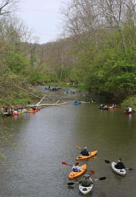
Wheeling Creek is very popular with locals for tubing as well as canoeing and kayaking, it is mostly flatwater with a few small riffles for most of its length. This creek is quite diverse as it cuts across West Virginia’s northern panhandle, moving from rural farmland and forest toward the more urban landscape of Wheeling at its confluence with the Ohio River.
You can dock or drop in at the ample put-ins and take-outs, and as Wheeling Creek nears the City of Wheeling, there are even some nice multi-use trails, parks and restaurants that line its banks.
The most ideal water level to paddle on Wheeling Creek is in the range: 1.8 feet - 4 feet. Anything below 1.8 ft will require extensive walking and dragging of your watercraft. Anything above 4 feet is NOT recommended and can become extremely dangerous. Remember to always tell people where you are going, time frame of your journey, go with a buddy, wear sunscreen, and don't forget your personal flotation device (PFD) per state law.
Put-in - Dunkard Fork Lane/Crow Creek Rd/Majorsville Rd. (Dunkard Fork WMA.) This is the furthest upstream section of the creek and the last upstream launch in West Virginia. This section can only be floated during high water periods. Please be careful and always wear your PFD.
Viola Sportsmans Club Creek Access. This section can only be floated during high water levels.
Bonnie's Bar in Viola, WV is home of the famous full wings. This location is great for large group creek access with great parking. Public and private creek access at this location. This section can only be floated during high or moderately high water levels.
This location is also known as the Ranch Bar and Grill and the Old Shepard Iron Bridge. The official launch site is across the creek and the bridge from the bar. The bar has ample parking and easy access regardless of which side of the creek you launch.
The Old Coal Mine Bridge is a favorite fishing spot for locals and a private launch location.
Popular fishing spot located near a city playground, three baseball fields, tennis courts, and ample parking.
Wheeling Jesuit University on Washington Avenue, just of I-70, provides ample parking and near multiple local restaurants.
Kroger is a full service grocery store with ample parking and great creek access.
This public launch has a baseball field, roller hockey rink, picnic shelter, Wheeling Heritage Rail Trail access, and a dog park.
This site is the mouth of Wheeling Creek and water access to the river for paddled watercraft with adjacent proximity to the Wheeling Heritage Rail Trail.