| Difficulty | III+ |
| Length | 11 mi |
| Avg Gradient | n/a |
| Reach Info Last Updated | April 7, 2025 |
River Description
This is a fantastic packraft run featuring a majestic hike through old-growth rainforest, fun whitewater, multiple mossy gorges, and towering cedars along the river. The river can be accessed at multiple points to make for a class IV+, III, or II+ day.
The first mile from Kimta Creek to Elip Creek contains some class IV+ drops in a cliffed out gorge. Be prepared for a very difficult climb out if there is gorge spanning wood clogging a drop. All drops can be scouted, but only one can be portaged.
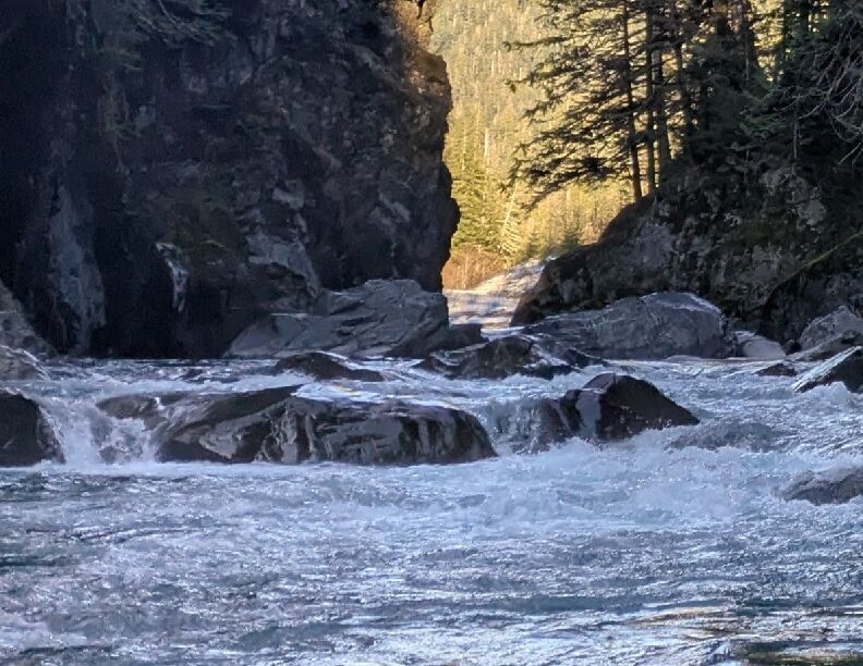
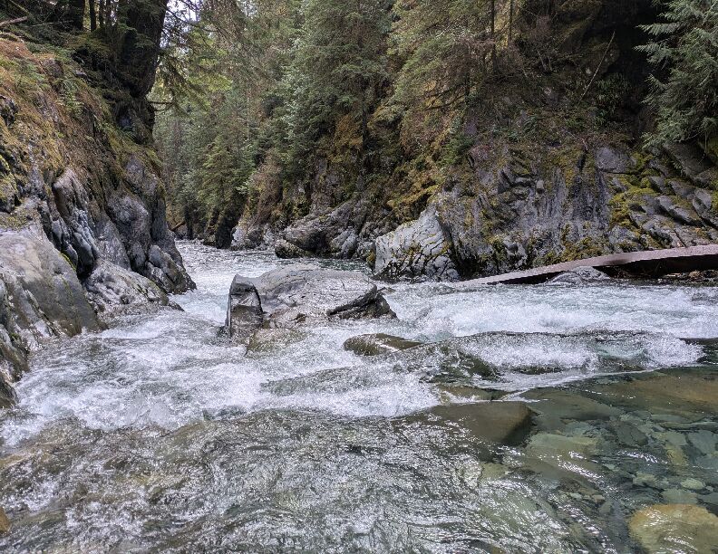
The next four miles starting at Elip creek or Halfway House contain fun class III whitewater and some beautiful gorges.
Shortly after the last gorge just downstream of Wolf bar camp, the next six river miles to the Quinault bridge settles down to class II+ braided river. There are big views of the surrounding mountains as the river braids through active floodplain. Watch for wildlife and enjoy the views. Keep an eye out for wood in this section. This stretch of river can be accessed via a couple points along the hiking trail, along the road, or at the bridge over the Quinault below the confluence with the main stem.
River Features
North Fork Quinault Trailhead
Access PointDistance: 7.33 mi
From this point on you will need to hike to reach the upstream access points.
47.57598, -123.64791
Quinault Bridge - Canning Creek
Access PointDistance: 11.44 mi
The road bridge across the Quinault River at the confluence with Canning Creek.
47.53343, -123.67805
Trip Reports
Log in to add a reportNB
Kimta Down - Nick Boguslaw
Apr 5, 2025
Packrafted the NF of the Quinault from Kimta Creek down to the Quinault bridge this past weekend, 4/4/25-4/6/25. Spent a couple nights at the lovely Wolf Bar Camp. Flows were 2900cfs @ Quinault, 1200cfs @ Humptulips, and 1900cfs @ Hoh. Note that the Quinault gauge is at the outflow of the lake, which is not a great indicator of the inflow, so it is useful knowing the levels of some neighboring watersheds. I'd say these flows were a good low-medium level.
The hike in through the Quinault rainforest was beautiful. Everything is blanketed in green. The old growth trees are awe inspiring. There were a couple dozen blow downs, but nothing difficult. There are a couple creek crossings at Wild Rose and Elip where water shoes were nice. The bridge at Stalding Creek is technically closed due to a tree that fell on it and damaged it. It is possible to ford that creek as well.
The first mile from Kimta Creek to Elip Creek was intense. The gorge the river cuts is pretty sheer and would be difficult to climb out of. There are several class IV+ drops, a handful of IVs, and a bunch of class IIIs. They are mostly formed by large chunks of polished bedrock wall that have fallen into the river alongside some large boulders. A typical hundred yard sequence would be a class III entry drop, followed in quick succession by a class IV, then by a couple more class IIIs, and then a moving ~30 yard recovery stretch. Gradient is about 100 feet per mile. We managed to scout all the big drops. Only one of the class IV drops was portagable. Thankfully, the run was pretty clean, there were no pieces of wood in play that blocked the entire river. Our flow felt pretty ideal for this stretch. Enough water to open up a few lines, but not too much to get really pushy. Overall, I would only recommend this stretch for solid class IV+ to V paddlers that have the means to scout for wood and climb out of the gorge if necessary.
From Elip Creek to the last gorge just downstream of Wolf Bar Camp, the river mellows to fun class III. Most of these rapids are staircase style drops down boulder bars into a cut bank. There are four beautiful gorges in between meandering river with big open views. This is a great stretch for intermediate paddlers. There are a couple river wide logs in the gorges that we paddled under that could continue to collect wood over time. The second log may be impossible to pass under at medium to high flows. It might be possible to climb over its root ball on river left.
Once past the last gorge below Wolf Bar Camp, the river changes in character again to class II+ braided channels in a dynamic flood plain. This stretch is swift in places with a lot of wood and some funky eddy lines. Our flow would be a good low water cutoff to avoid too much bumping and dragging. We had two easy portages around log jams. There are big views of the surrounding mountains. We spotted a couple families of elk, a couple types of eagles, a wood pecker, and a couple pairs of harlequin ducks. We took out just downstream of the Quinault bridge at the boat ramp on river left.
NB
House Creek Camp to Maple Cobble Wash - Nick Boguslaw
Jan 27, 2025
On 1/27/25, we hiked from the NF Quinalt River Trailhead about 6 miles to Halfway House camp, where we put on. The hike was stunning. Massive old growth Sitka Spruce, Cedar, and Big Leaf Maple were everywhere and draped in moss and ferns. Trail was well maintained and climbed gradually. We put on our drysuits to ford Wild Rose Creek as the stepping stones were spaced out and icy. The water was swift and about knee high. Could be challenging at high water.
Almost immediately after putting in just upstream of Halfway House Camp, we dropped into our first gorge of the day, 'Wild Rose'. The first drop was characteristic of most on the run, cascading down a class 3 boulder bar into a pool. After almost a half mile or so of gorgeous bliss, a massive log marked the exit. It was wedged between the canyon walls, 6 feet in the air. Unsure at what flows this log would pose a hazard.
After leaving the first gorge, the river opens up for about a mile with rolling mountain views. You pass Rustler creek as it comes in off the left. There are a couple of boulder bar drops in this section that slam into bedrock banks, creating some swift hydraulics.
Before you know it you are descending into the second gorge, 'Over/Under', which lasts about a quarter mile. This gorge also ends with a massive 5' in diameter log wedged from wall to wall. This log could be more problematic. At 1000cfs, the left side was at river level and the right side bowed up to create about 5' of clearance. Not sure how quickly that right side underpass would close up with more water. Upstream of the log the banks were pretty cliffed out. Log location: 47.6067955, -123.6158091
The next 3/4 mile opened up again as you pass Wolf Bar Camp on your right. Shortly thereafter, you enter the 3rd gorge, 'Sentinels', which contained a couple of the best rapids of the day! These felt like solid class 3's as you negotiate some large boulder rockfall. Massive old growth cedars tower overhead.
After leaving the 3rd and last canyon, the river starts to mellow out and braid. Wood is more prevalent. We had one mildly tricky portage. We continued on for about another mile before taking out where the trail nearly meets the river near a grove of maples growing in a dry cobble wash.
Flows were about 1000 cfs on the Quinalt River gauge at the Quinalt lake outlet. Level was very low. We had to get out and walk our packrafts on a few cobble bars. We butt scooted down a couple dozen more. The rapids were boney. But we appreciated the lower water while exploring a gorged in run with next to no beta. Would like to see it a bit higher next time.
A note of caution on the gauge readings. The gauge is measuring the outflow of Quinault Lake. On a rising gauge during rain or snow melt events, the inflow could be dramatically higher than the outflow readings. The lake acts as a giant dampener.
We look forward to going back this summer to explore the section from Kimta Creek to Halfway House. The only information we found on it were a couple obscure internet references to it being class III-IV in difficulty. Due to its cliffed in nature and its proclivity for gorge spanning wood, we are going to approach this section of river very cautiously.
Nick Boguslaw and Ariel Leigh