Honey Creek (Fox (IL) Trib)
East Troy Mill Pond Park (former dam site)
| Difficulty | I-II |
| Length | 0.65 mi |
| Avg Gradient | 10 fpm |
| Gauge | Bark River at Nagawicka Road at Delafield, Wi |
| Flow Rate as of 35 minutes | 25 cfsbelow recommended |
| Reach Info Last Updated | April 19, 2026 |
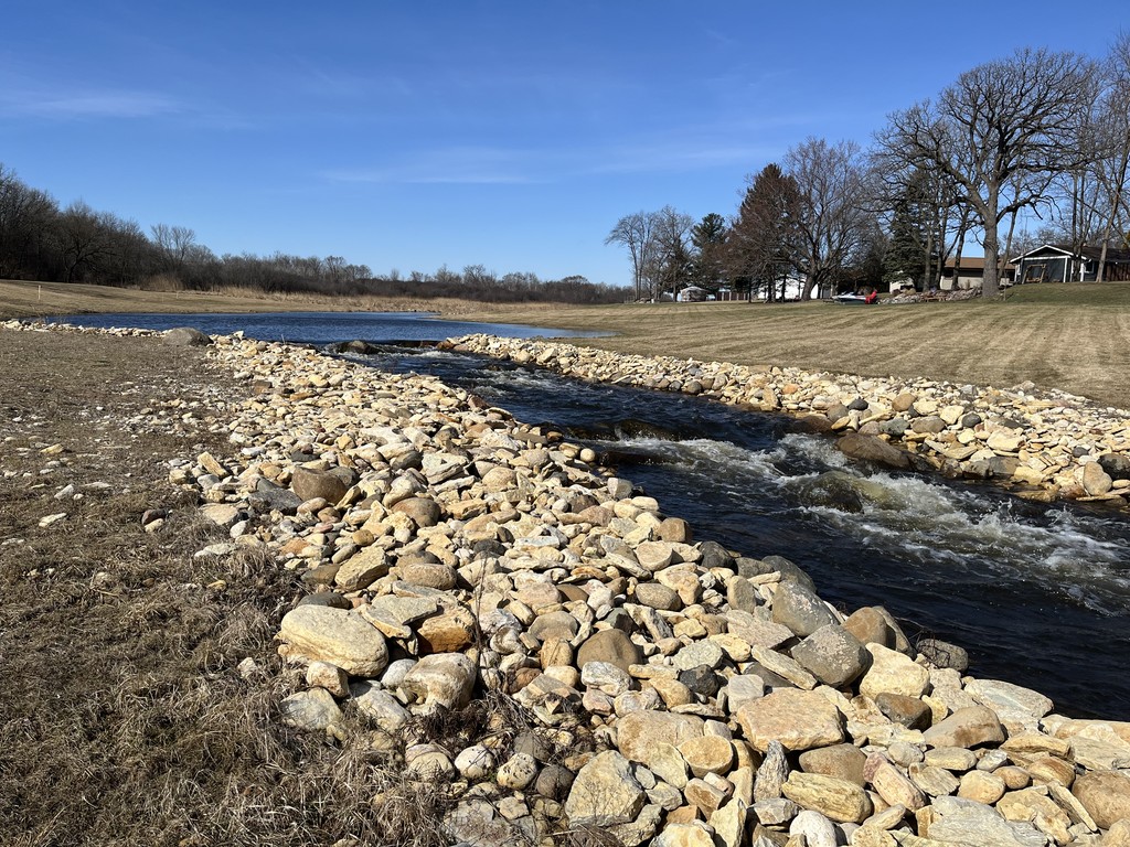
Removal of a dam in East Troy and consequent remediation of the streambed of former mill pond has created a spot which may catch the interest of novice boaters. While it may look like a bit of exciting whitewater, it is more likely to prove disappointing.
The remediation has created a few ponded areas by placing 'boulder chokes' in a few locations. Unfortunately, at most normal/usual flows, attempting to run these boulder chokes will mostly result in unavoidable impacts with rocks. After heavy rains (or times of significant snowmelt which S.E.Wis. seldom sees anymore), there may be enough flow to reduce or eliminate such impacts.
NOTE 1: the stream image in the 'river geometry' above uses an old topo map from before dam was removed. Click 'Map' to get to the map page, then click 'Topo' to change to 'Satellite' which will better represent present configuration of this creek.
NOTE 2: Our reference gauge lies 21 miles north, and has 35.9 sq.mi. drainage. Flows here might be 10% higher than listed gauge. (All closer gauges are subject to regulation, making them less useful.) Being 21 miles away, keep in mind actual rainfall will vary greatly across that distance, so expect gauge not to be 100% reliable for runnability here.
To access this reach, the best parking is at Mill Pond Park in East Troy, WI (or park roadside where the stream crosses under Church Street).
Since there is no gauge actually on this creek, walk north to the Church Street Bridge to check flow by looking at the final pitch. If it looks boatable, walk a tad further north to where you can see the prior pitch coming out of a ponded area. If that looks boatable, head back to your vehicle, gear up, grab your boat, and carry upstream (or set shuttle to the recommended put-in).
From the Mill Pond Park, a path leads nearly due west past the pond, into the woods, and then into a marshy area which was formerly inundated by the millpond. Carry to get upstream of the 'boulder chokes' on this stream.
For any dataholics:
Drainage area at put-in: 40.2 square miles.
10/85 upstream gradient: 8.91 FPM
Upstream development: 7.59%
The above data suggest that this may be moderately 'flashy' ... that is, elevated flow may last a couple days (not just a few hours).
The nearest bridge upstream (Town Line Road) has no shoulders to park on. The next bridge is about 0.75 miles upstream (at Hwy.ES), and appears slightly more favorable, but adds nothing but flatwater to be paddled.
Our recommended upper access (for anyone who wants to set a shuttle for this short run, rather than just carrying up) is from a storm drain easement at the corner of West Street and South Street. Park on the west side of West Street and carry down to the creek.
The creek splits around a rather sun-hat-shaped island.
The right (south) channel around the island carries the bulk of the flow, and is the recommended route. It has nothing of any interest since it bypasses the bolder choke in the left channel.
To the left (north), a lesser channel feeds into a ponded area. This inlet is extremely shallow. Even at relatively high flows, expect to be scraping the sand/muck bottom and having to 'pole' with your paddle to move through here. Once you arrive into the pond, depth improves as you paddle past houses and back yards. The outflow from the pond drops across the first 'boulder choke'. However, at most flows it'll be hard to find a clear path through this choke. Expect to be scraping across rocks, or portaging.
After a bit of ponding, as the stream narrows, another boulder choke is encountered. Since the first choke was in a split channel and this is in undivided channel, this one has the full flow of the creek, and will more likely be passable.
It may still require some good river-reading and skillful paddling to avoid rocks just under the surface as you run a small wave train.

Just around a bend from the prior choke, a brief ponding leads to the final boulder choke.A few large boulders (with separation between them) funnel water directly onto another rock, making this particularly awkward to navigate in any watercraft. Unless water is unusually high (or you are quite skilled or lucky), expect hard hits with some of the rocks as you run this wave train. Proper whitewater craft will handle such hits pretty well, but less expensive recreational kayaks might suffer damage.
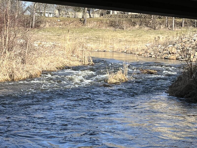
This final pitch had been present when the dam was still in place. This will be a very boney stretch unless the creek is running high. If the creek is high enough for this not to be boney, the most difficult aspect will not be the rocks, but will be that this straight-away (parallel to the road) takes a sharp left turn to pass under the road.
Current piles into the streambank, and so will you if you do not have solid skills to avoid being pushed into the rocks armoring the shore. If you charge into the river-right eddy, you can practice ferrying back and forth across the tail end of this flow.
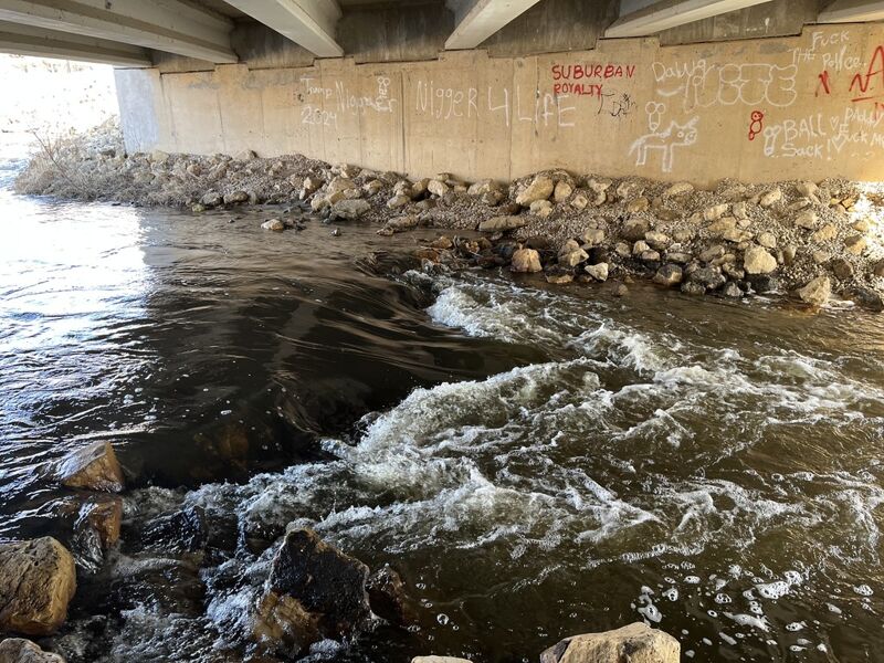
Many loose rocks populate the creek (especially the right side of the bend and culvert) as the creek passes under Church Street. A string of rocks spans the creek (unkown if this was by design or more likely by the hands of some local kids). If this had been a bit more subtantial it might have created a minor playable wave, but at boatable flows it is totally awash and uninteresting.
Take-out at the downsteam side of the bridge where you can find a handy spot to beach and get up through the brush on shore. Carry back to your vehicle at Mill Pond Park (or carry up for another go at it, if you found anything worth another carry-up).
For those interested in a more extended outing, the current remains quite good on most of this creek. Expect to have occasional obstruction by deadfall (though aerial views show most of the creek pretty open). You may find some areas of swiftwater, but you are unlikely to find any additional significant rapids.
FWIW, ~5.2 miles east of here (as the crow flies ... not river miles nor road miles), Hwy.20 crosses Honey Creek (about 1.7 miles north of the unincorporated community of Honey Creek, on the county line between Walworth and Racine counties). Leading into and under that bridge (just west of a railroad crossing), there is another bit of swiftwater. An assortment of rocks lines the shores, and slightly interrupt the stream. However, at any boatable flows there is really nothing of interest to a whitewater boater.