| Difficulty | I-II(III) |
| Length | 14 mi |
| Avg Gradient | n/a |
| Gauge | Haw River Near Moncure, Nc |
| Flow Rate as of 48 minutes | 216 cfsbelow recommended |
| Reach Info Last Updated | December 12, 2025 |
River Description
Buckhorn Falls Rapids:
This part of the Cape Fear isn't particularly popular for whitewater paddling and is more a section used for longer camping trips to Raven Rock State Park or flat paddling/fishing before the rapids start. It does, however, offer some interesting whitewater features and good attainment practice for those who enjoy a workout and for less experienced or kayak/canoe camp paddlers, has some risk to be aware of. It also is a chance to paddle rapids if you missed the water levels for the Haw and Deep Rivers days after they have spiked. Park near the Buckhorn Dam at the end of Buckhorn Rd in Corinth, NC, which is a bumpy dirt road with many potholes throughout and put in below the dam. Do not put in anywhere near the hydraulic immediately below the dam. About half a mile downstream are the Buckhorn Falls rapids, which is a boulder garden that goes for about a quarter of a mile.
Easier Camper's Route:
For longer trips and less challenge, stay river left on the main channel till the rapids end. Do not enter the narrow channel that appears on the far left after passing the trail on the left bank since this is often clogged with down trees. There will be several small ledges and rocks to dodge, but rapids are less challenging on this side. Avoid rocks and keep your momentum moving downstream with the flow, but otherwise it should be fairly straightforward with rapids ending just beyond an island in the middle of the river. For those less experienced with whitewater or campers loaded with gear, I'd recommend not running this above 3000 cfs (combined flow from Haw and Deep River at Moncure) or over 4.5 ft on the Cape Fear Gage at Lillington. At very high levels, these class I-II rapids start approaching marginal class III difficulty with holes, strong current and swirly eddies. While the rapids are not difficult for an experienced whitewater paddler, risk of problems is high due to the remoteness of the locatio
...River Features
Buckhorn Falls Rapids
RapidClass: IIDistance: 0.63 mi
Stay river left of the main channel for easiest route. River right of the main channel and far right channel offer more of a challenge.
Buckhorn Creek (Route for Hiking Back Upstream)
Access PointDistance: 1.25 mi
If you do not want to continue downstream and you do not want to try and attain, work river left of the island about 3/4 of the way through the rapids. On the far left after the rapids end, you can paddle up Buckhorn Creek. It is easiest to paddle till you reach the rapids on the creek and get out upstream left (river right on the creek) and follow the muddy trail back to the parking area by the dam. It is about a one mile hike. You can also use this trail to hike up to the rapids on the creek, which are fun if there is at least 100 cfs reading on the Buckhorn Creek gage at hwy 42.
Lanier Falls
RapidClass: IIDistance: 5.91 mi
Stay river left for a more gradual drop or river right for a steeper, more abrupt drop.
Fish Traps
RapidClass: I+Distance: 6.92 mi
Paddle In Camp Sites
OtherDistance: 8.54 mi
Lillington Take-Out
OtherDistance: 14.45 mi
Just upstream of the Highway 401 Bridges on river right.
Trip Reports
Log in to add a reportZS
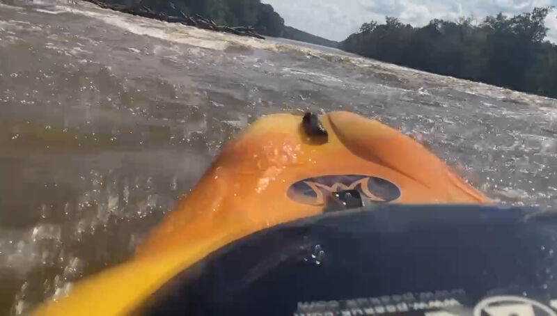
High Water Run (Conservative Route) - Zach Schiada
Oct 7, 2024
I ran the Buckhorn Falls rapids and then ran Buckhorn Creek at higher water. The river rapids, river left were not too difficult at 9,555 cfs combined on the Haw River and Deep River gages upstream. Current was fast, strong and medium to large eddies and cross currents. Waves were a bit smaller than I had anticipated with none over about 2 ft, but I think river right would have been significantly more challenging. I chose to go river left where the drops are smaller to not risk missing my take out where Buckhorn Creek comes in. I glanced at the river right side, which looked like a bit more action. That is the side I normally take at lower levels and it is more interesting over there. None of this would be difficult for those who paddle more other rivers in the area such as lower Haw or anything else with some class 3, but this section would be potentially dangerous for inexperienced paddlers at high water.
I have an OK video of what the river looked like in the link below. Buckhorn Creek is on there too, but the angle is hard to see the rapids.
https://rumble.com/v5hlxt0-buckhorn-falls-cape-fear-and-buckhorn-creek.html