Hoh

1. Lewis Meadow to Hoh Campground(Upper Hoh)

Reach banner
DifficultyIII
Length13 mi
Avg Gradientn/a
Reach Info Last UpdatedSeptember 29, 2025

River Description

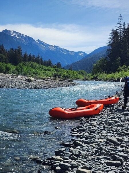
The Upper Hoh River, located in Olympic National Park, offers a spectacular backcountry packrafting experience through one of the most iconic temperate rainforests in North America. This glacial-fed river flows westward from the base of Mount Olympus, cutting through lush old-growth forest and carved river valleys. A typical packrafting trip begins with a hike on the well-maintained Hoh River Trail, which starts at the Hoh Visitor Center. Most paddlers choose to hike in 9 to 12 miles, with common put-ins near Lewis Meadow or even as far as High Hoh Bridge for a longer and more remote adventure. The take-out is typically near the Hoh Campground, though longer trips can continue down to Oil City Road at the river's mouth.

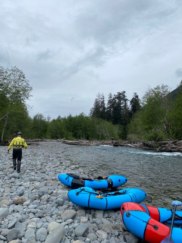
The Hoh is known for its strikingly blue glacial water, dense rainforest scenery, and abundant wildlife, including Roosevelt elk and black bears. The river is swift and braided, featuring cold, silt-laden flows with frequent logjams, undercut banks, and strainers. Most of the rapids are Class II to III, but the technical challenge lies more in route-finding and avoiding wood hazards than in big whitewater. Conditions can shift dramatically depending on recent weather and glacial melt, so scouting and conservative decision-making are essential.

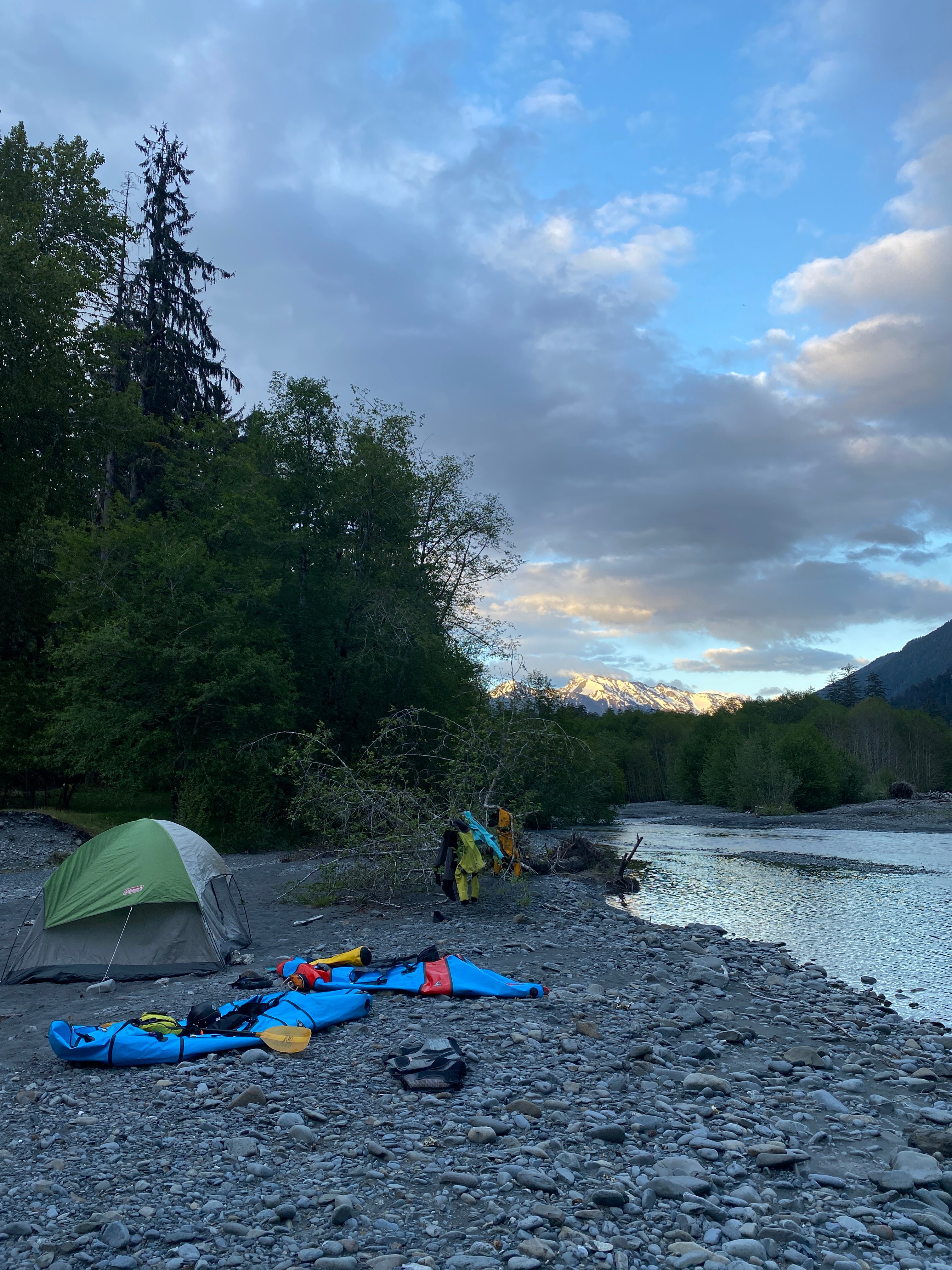
This trip is best suited for intermediate paddlers with solid whitewater skills, swiftwater rescue knowledge, and full cold-water gear—drysuits are highly recommended due to the frigid glacial melt. Packrafters must also be self-sufficient and prepared for backcountry travel. Permits are required for all overnight trips in Olympic National Park, and bear canisters are mandatory. Camping options are available at designated backcountry sites along the trail and at the Hoh Campground near the take-out.

Trip options range from a one-day push—hiking in early and paddling out the same day—to a more relaxed overnight with riverside camping. Those looking for a longer trip can continue down the Mid

...

River Features

Lewis Meadow Camp

Distance: 0.99 mi
Other

Lewis Meadow Camp is a scenic backcountry campsite located along the Hoh River Trail approximately 10 to 11 miles from the Hoh Rain Forest Visitor Center. There are multiple sites in the meadow and closer to the Hoh River.

Olympus Ranger Station

Distance: 2.69 mi
Other

The Olympus Ranger Station, also known as the Olympus Guard Station, is a historic backcountry cabin situated in Olympic National Park, Washington. Located along the Hoh River Trail near the junction with the Hoh Lake Trail, it sits approximately at river mile 45 on the north side of the Hoh River. Constructed in the 1930s by the U.S. Forest Service, the station was designed in the rustic architectural style characteristic of that era. It served as a base for rangers patrolling the remote wilderness areas of the park. Today, it continues to function as a seasonal outpost for the National Park Service, supporting trail maintenance, backcountry patrols, and visitor assistance during the summer months.

Five Mile Island Camp

Distance: 6.78 mi
Other

Five Mile Island Camp is a scenic backcountry campsite located approximately five miles along the Hoh River Trail.

Hoh Rainforest Campground Take-Out

Distance: 12.6 mi
Take Out

Access on river right from the Hoh Rainforest Campground. The Hoh Rainforest Campground, located within Olympic National Park, is known for its lush rainforest environment and proximity to hiking trails. It offers 88 campsites suitable for tents, trailers, and RVs up to 21 feet. Amenities include flush toilets, potable water, and food lockers. The campground is open year-round, with reservations required from mid June to mid September.


We started on Saturday from the main parking lot and hiking our overnight gear and pack-rafts to Olympus Ranger station put in about 9 miles up the valley. Downstream gauge data had the river at around 1040 cfs. Trip took about 6 hours with gear. Busy camp on Memorial day weekend but the weather was nice. There was one spot in last mile where a tree had fallen making the trail nice and steep and scramble for the better part of 50 feet. Almost zero chances to scout wood on the river from the hiking trail but from reports and noting that the olympic rivers get a lot of wood each season, we had an idea that there would be a few portages. The next morning we woke up and put on the water around 11:00. We had highs in the 60s and were in wetsuits and that was comfortable for the whole day. In total we had 8 separate portages throughout the day and more then 10 'walking the dog' portages where we attached our flip lines to the packrafts and used the water to walk the boats down along the side of the river to avoid nasty strainers/wood and sections that were too shallow to fully paddle down. Splitting the river into 3rd's, the heaviest portage section was the 2nd out of 3 where we had a 1/4 mile hike downstream around 5 mile camp and 3 back-to-back portages shortly after. Consider the weight you bring because you will be carrying your boat frequently. The challenge of this section was navigating braided channels and staying vigilant/scouting wood, but there were a few class I-II little wave-trains that were splashy and fun, and a couple of surf waves. Besides those, the river was absolute beautiful with glacial blue flows and sunshine pretty much the whole day. Didn't see any other paddlers and had the river to ourselves. We took out right at the campground near the visitor center which had orange flagging on river right to designate river access from the campground. Takeout time was at 17:30. Would do again, maybe even from higher up but plan on a full day and lots of walking. 1.1k

On May 10th and 11th our group paddled the Hoh from a little past Happy Four Campground (N 47.869589° W 123.816752°) to Hoh River Campground (N 47.857803° W 123.938542°). The section was about 8 miles of river, though could be made shorter or longer depending on choice of put-in.

Flow: Gauge downstream on the Hoh measured 1150 cfs on 5/11

Other logistics: Will need national park pass (or daily rate) + wilderness permit

Day 1:

We parked in the backpackers lot at the Hoh Rainforest area. We hiked up the Hoh River trail for about 5 miles to 5 Mile Island Campground. There is a pit toilet at this campground. We were hoping to get more eyes on the river as we came up the trail to scout out log jams and rapids but didn’t get consistent views of it. At the campsite, we set up camp and dropped any unnecessary gear. We repacked our bags with our packraft gear to hike up for a little afternoon bonus paddle.

We walked another mile and a half up river and then followed a dried up creek bed to the river (turned at N 47.869772° W 123.816763°). We considered hiking further to the next campground for a longer paddle and easier put in but we were feeling tired and wanted to mindful of the time potential wood shenanigans might take coming back to camp.

Our first paddle leg from 1.5 mi upstream of camp to 5 Mile Island was fun. Some splashy class IIs and a couple waves to surf in. The scenery was incredible, we even got some sun. There was a channel spanning log jam that we portaged right after Happy Four Campground. Then as you approach 5 Mile Island Campground, the river braided into 3 channels, with wood across all of them. We stayed river right, and did a couple portages, re-entering the river after the little birch tree forested section, right before the campground.

Day 2:

We had a peaceful, quiet morning enjoying the scenery and watching the ducks nearby. From 5 Mile Campground, onward, there were some pretty large log jams. For a couple of them we shifted to a different river channel, portaging for 1/8-1/4 mile. For the large jam right before Mount Tom Creek (N 47.865327° W 123.875354°), we portaged to the right, through the birch forest, to the low water channel on the other side of the forest. This might be less pleasant as water levels drop.

After Mount Tom Creek, we got some reprieve from the wood. There were maybe another one or two more log jams that required a short portage.

Take out: Where the left braid of the river we were on reconnects with the right one near the southwestern loop of the Hoh Rainforest Campground (N 47.857803° W 123.938542°).

Overall more splashy fun class IIs, wildlife, incredible scenery. We had to booty scoot and walk our boats a little but it wasn’t too frequent. There were plenty of eddies and opportunities to scout wood hazards; but still definitely keep your eyes up! We had both the campground and the river to ourselves. A wonderful trip!