Chateaugay
Lower Chateugay Lake to Cooks Mill
| Difficulty | II-V+ |
| Length | 12.4 mi |
| Avg Gradient | n/a |
| Gauge | Great Chazy River at Perry Mills Ny |
| Flow Rate as of 2 hours | 1.87 ftbelow recommended |
| Reach Info Last Updated | September 24, 2020 |
The Chateaugay is a very fun and scenic run in Northern NY, near the Canadian border. Much of the river is in a deep and committing gorge. There is a huge (100-ft) 2-stage waterfall on this run that looks pretty much unrunnable to me. There is also a large dam that is usually portaged. Because of the steep walls of the gorge, some of the rapids are difficult to scout and there are several places where it would be close to impossible to get off the river. The river also goes through a long tunnel. Make sure there is no wood in the tunnel before you run it. Overall, a great run.
Dennis Squires reccomends in his book to run laps on the top 2 miles taking out at High Falls for the best Class 4.
radpat shared:
'We ran this May 28 (2011) at 54m3/s (1900 cfs) on the gage in Huntingdon, Québec: See Hydro Quebec, click on Saint-Laurent sud-ouest, and then Huntingdon gage. (Lynx will open in a new window.) 54m3/s (1900 cfs) is very good and it's possible to stop and scout; 70m3/s (2470 cfs) is fast, with no scouting possible; 100m3/s (3530 cfs)...???
'The first 6 miles of rapids is class 2 nonstop, great for canoeing. Then the action starts one mile after you cross the big power line. We will try to put in there next time....looks like a half-mile walk to get to the road. The first rapids in the canyon can be run in the middle, then far left. Lots of small ledges and slides, one after another, in a 100ft tall canyon--no way to exit, with pocket-sized eddies, and no way to scout very much. No Scout Rapid is crazy, with a big rock in the middle at the end of the drop, with a monster hole and pinning risk. Run all the way right and then sprint left for the next drop to avoid a sticky hole. For the next drop, run
...
Make sure you get out well before this one. Squires says that after 1.5 miles, the river narrows down and takes a sharp bend to the left. Get out on the right before the bend--or else you're running it blindly.
No Scout Rapid is crazy, with a big rock in the middle at the end of the drop, with a monster hole and pinning risk. Run all the way right and then sprint left for the next drop to avoid a sticky hole.
Lat/long coords for this one are approximate, from online maps.
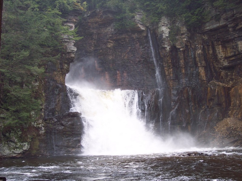
This two-stage 100-footer is a mandatory portage.
Apr 28, 2025
We ran this section on 4/28/2025 at roughly 48m3 per the Huntington Dam readings. We parked at the powerline upper lot on Healy Rd. and walked the boats to the river.
Following a couple hundred yards we came across the first couple of slides. First Slide we ran right to left crossing the first diagnal hole at the base of the left cliff. Second slide had a significant hole in the bottom center with wood. We ran down the left. Before the canyon holding 'No Scout' is a wide/slow moving section of river. We got out on the right in a grassy flat to attempt to scout the canyon via drone. In the canyon are two notable low angle slides going through tall canyon walls. When the walls begin to shorten in height look for any eddie plausable to catch and get out for a scout of 'no scout' on river right. We came into it by suprise and it is A RIDE! Staying all the way right would be the most favorable line. The hole immediately after No Scout is easily boofable at this level but boogying left would be fine. The next slide has wood on the left but center or right is clean.
The first dam is an easy portage hiking up the access road and finding a trail on the left that reconnects you to the second dam access road.
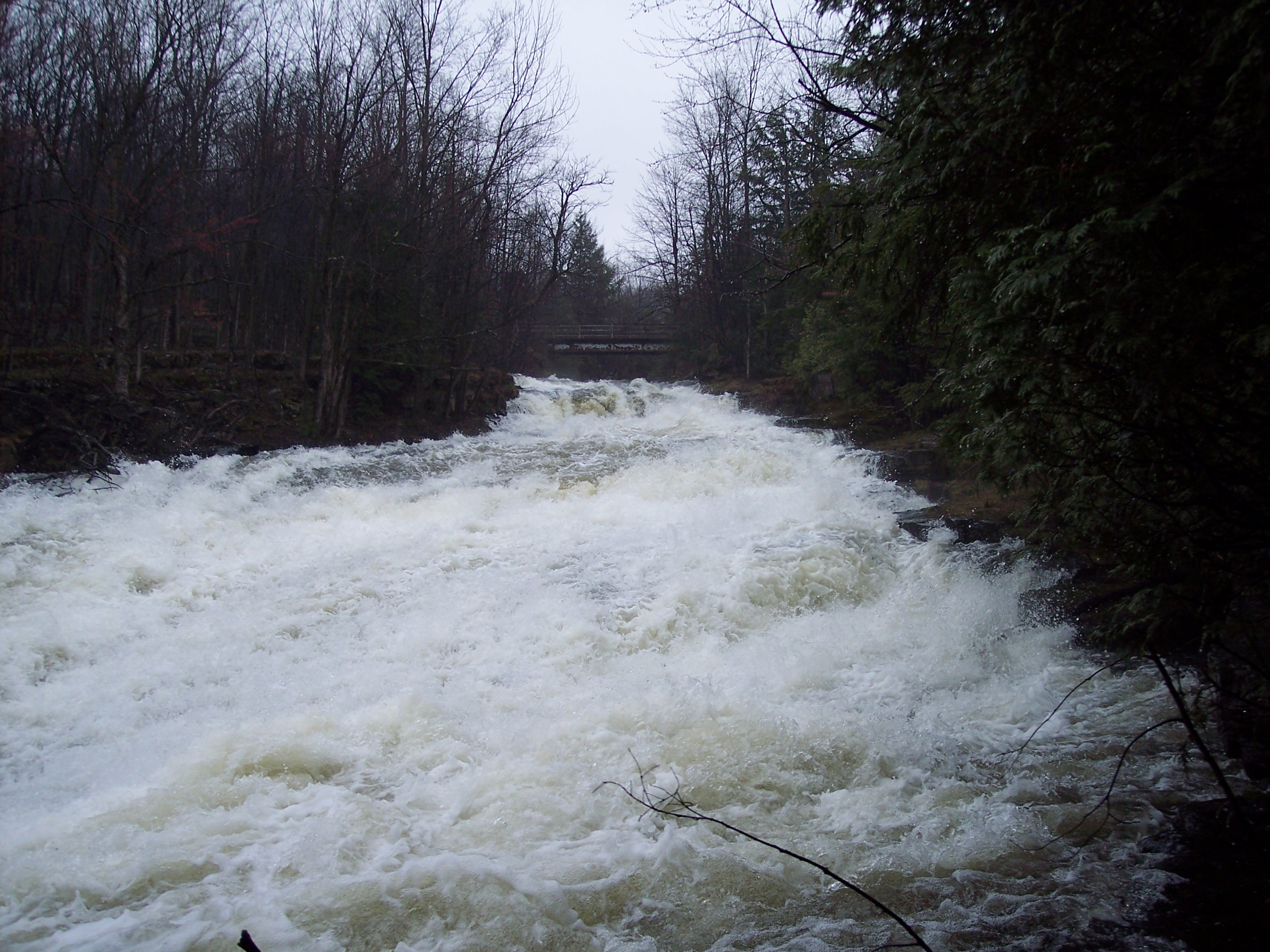
Lots of class two boogie water to the tunnel. Drive down the center for a great boof. Right after the tunnel drop move river left. the river right channel is clogged with strainers.
We looked at the runnable dam and decided to cut out trip short there with intentions of returning to complete the run at a later date.
Nov 9, 2016
Diddle diddle is a great park and huck section. Super easy to get there by car, park and get the most out of it with friends.
We use to park on the side of the road (https://goo.gl/maps/mX6UR3XDy2C2).
Please get in and out of the river by river left. Lokks like a lot of people go to this section (fishermen, kayakers, etc). There's already path made. River right have private property.
We have done this section several times at around 30 cms on Huntingdon Hydro Quebec gauge. I would recommend it a bit lower (not lower than 25cms).
54 cms in 2011 (see RadPat comment) was great and real fast. Let's share your experiences!!!
May 29, 2011
WE ran this may 28 at 54m3 on the gage in huntingdon, québec:
http://www.cehq.gouv.qc.ca/suivihydro/default.asp
Then go it under sud ouest region, and then huntingdon gage.
first 6 miles of rapids is class 2 non stop, great for canoeing. Then the action starts one mile after you cross the big power line. We will try to put in there next time....look like half a mile walk to get to the road. First rapids in the canyon can be run in the middle then far left. Lots of small ledge and slide on after another in a 100ft tall canyon, no way to exit, pocket size eddy, no way to scout very much. No scout rapid is crazy, big rock in the middle at end of drop for monster hole and pinning. run all the way right and then sprint left for next drop to avoid sticky hole. Next drop run staight in the middle or far right. Easy take out before the falls, unrannable. follow the road for easy walk and trail on the left. After the falls, 1 miles of class 2 rapids before tunnel. 10 feets fall at the end of the tunnel, jump right, you should buschwalk the mountain to go see if there is no tree in the fall.... next is 1 miles of small slide and play holes to the dam. Run straight in the middle of the dam and scream ! Small rapid to recover if your not dead. Next drop should be run on the far left. Then you will see a bridge and hit the last slide, a long, fast and furious slide rapid name Hey Diddle Diddle......straigh in the middle......finish with one mile of class 2 rapids. Full face and elbow pads are recommended for this run
54m3 very good and possible to stop and scout
70m3 fast, no scouting
100m3 ....????
Apr 30, 2007
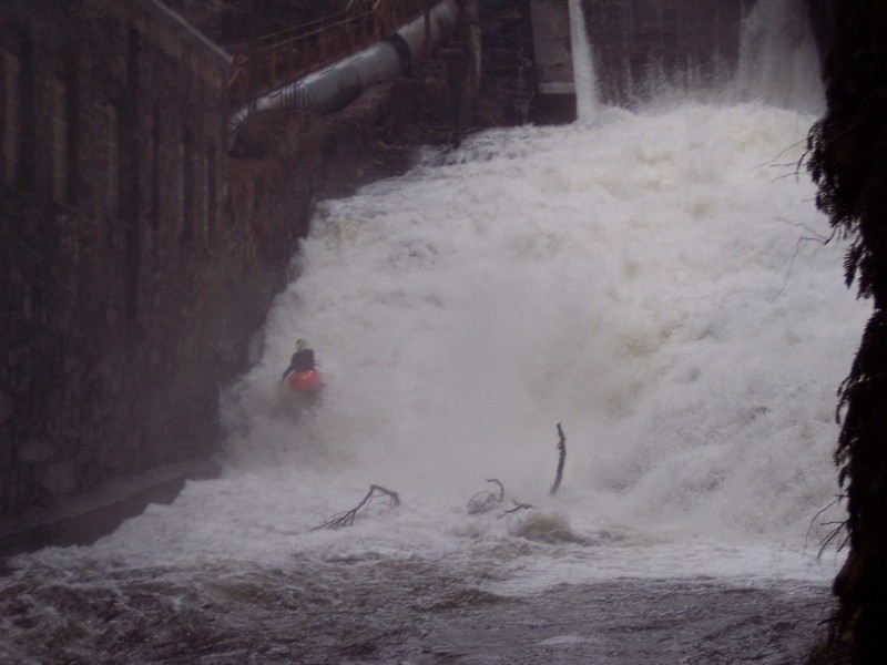
As of 4/29/2007 there is wood in the main line at The Dam Slide. It looks like it would be big trouble if you tried to run the main line. You can put in lower on the slide and run the far right into a boof and go right of the wood. When the level drops there may be a remove the wood expedition. Also don't let the ugly dam and building fool you. Much of this run is in a narrow gorge with up to 100 ft walls on both sides.
Jim D
Apr 29, 2007
As you can see in the picture there was wood in the regular line. We snuck down river right and boofed into the pool. The wood is in the main line and is very dangerous.
You can actually scout 'No Scout' but make sure you get one of the last eddies.
We had to much fun running the rapid to get a picture of someone in the rapid. Don't know if that is the real name of the rapid. It is called that because the way you run it. Hey Diddle Diddle right down the middle!
Last part of Hey Diddle Diddle. Keeping your bow up and your boat straight is a good idea.
As you can see this slide starts at the base of a dam and runs next to powerhouse.
This is the second (and smaller part) of a 2 stage waterfall on the run. The first part is part waterfall part dam and is huge. They look unrunnable to me.