Deer (Black trib.)

1. New Boston to High Falls Dam

Reach banner
DifficultyII-III
Length11 mi
Avg Gradient31 fpm
GaugeEast Branch Fish Creek at Taberg Ny
Flow Rate as of 583 days
164 cfsstale data
Reach Info Last UpdatedApril 14, 2016

River Description

Updated June 25, 2001

The Deer River is a remote and seasonal waterway on the northern slope of the Tug Hill Plateau that drains into the Black River. From the putin, you will paddle 11.7 miles before seeing another road.

Watertown Area Reaches:

Black River (Rt. 3 Wave) Black River (Watertown to Brownville)

Black Creek Deer River (Section 1)

Deer River (Section 2) Roaring Brook (Brokeback Gorge)

Salmon River (Section 1) Salmon River (Section 2)

Sandy Creek South Sandy Creek (Section 1)

South Sandy Creek (Section 2) Mad River

Mill Creek Negro Brook

Tug Hill - Old Forge Area Reaches

...

River Features

THE PUTIN

Distance: 0 mi

The putin is located at the Route 177 bridge in New Boston. On the downstream side of the bridge, on river left, is a drainage ditch that leads down to the river bank.

For a decent run, the water level must be high at the New Boston bridge. If the water level just looks 'runnable' at the bridge, you will not have a good time. Further downstream, the river braids into wide channels than can be very shallow (unrunnable).

THE GORGE

Class: IIIDistance: 0.1 mi
Rapid

From the putin you'll promptly enter a deep shale gorge that is about 7 miles long. Visually the gorge is reminscent of Fish Creek, with the paddling difficulties of Letchworth Gorge. The play features are small but very plentiful.

The Deer River gorge is deep, remote and stunningly beautiful. Wildlife abounds. Rarely the river abuts the shale cliffs, forming exciting class 3 wave trains and occasional holes. More frequently, though, the river braids and weaves back and forth across the bottom of the gorge, forming numerous channels.

THE FLATS

Class: IIDistance: 7.3 mi
Access Point

At 7.3 miles from New Boston, the volume of Deer River increases when a major tributary (Cobbs Creek) enters on river right. This marks the end of the gorge and the start of 'The Flats.' This section of the river is reminiscent of the tamer sections of the Salmon River in Pulaski.

At 11.7 miles (or 4.4 miles from Cobbs Creek) the river enters the town of Copenhagen and runs under the town bridge. Immediately past the Route 12 bridge is a series of class 3 ledges.

You may take out above these ledges.

HIGH FALLS DAM (TAKEOUT)

Distance: 12.4 mi
Take Out

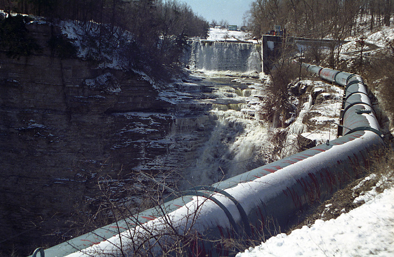
At 12.4 miles the river plunges over a 25-foot high dam and then plummets 100 feet over High Falls. A small hydroelectric station is located at the dam. The takeout is located on river left, just above the dam.

WARNING!****High Falls is not runnable, and you will die.


JR
Jacob Rosenthal

Apr 23, 2022


We ran this yesterday (4/22/2022) at 2k on the correlation gauge (East Branch Fish Creek).

At 2k, there was only a tiny bit of scratching and it could largely be avoided. I'd say difficulty is probably similar to the Salmon river in the gorge. Maybe a couple of easy III's or hard II+'s. We only had one strainer we had to portage which is kind of miraculous considering how long the gorge is. It is very continuous. There are eddies to pull off into every once in a while but it kind of just goes and goes and goes. It's a pretty section, but there's not much relaxing. It would probably be spectacular in the fall as it's just choked with sugar maples (and there's a large sugar bush operation at some point down in the gorge).

There are some proper III's in town. The biggest direct drops are the two 3 foot ledges at the bottom of the rapid, but you can T up to them and run them pretty cleanly. The top two are a little more technical (make sure you scout all of the rapids there). The one under the bridge seems like it may be the meatiest of the four. There's a tongue on the right I'd advise if you're in an open boat, otherwise the laterals and waves at the bottom may knock you over if you bomb down the center (that's what happened to me). After the bridge drop, there's another drop maybe 10 yards after but it has a clean slide on the left side. There's an eddy at the bottom you can catch too if you do dump. The next two ledges you'll have to scout depending on water level. My partner ran them both on far river right at 2k. At higher water pretty much everything would probably go, but the ledges may turn into river wide holes. Its a bad place to swim pretty much on any of it so know your limits. There are some shallow spots to maybe stand up if you ended up swimming, but it's slick and going over the drops without a boat would probably suck pretty bad.

As you may ahve discovered, that section to which you refer is very difficult to scout. Looks good in places, with some big drops, but it's really hard to get back there and scouot.

Dan Cash
Dan Cash

Mar 20, 2009


We paddled this section last year and it is an amazing river. Countless surf waves in a beautiful shale gorge and a myriad of cascades falling over the walls. I counted more than 50 individual falls coming into the gorge. Not many run this, but it is well worth a look. In the 11 miles we only caught 4 eddies. 100% boogie + surfing. I can't wait to do it again.
On a side note: Does anyone have any beta on the section below High Falls? It looks like it may have a more drop/pool nature than New Boston part or at least some bigger drops.

The High Falls dam in winter, the takeout for the Deer River.