Little Woodhull Creek
Dam on Kincaid Road to Woodhull Creek
| Difficulty | III |
| Length | 9.1 mi |
| Avg Gradient | n/a |
| Gauge | Black River Near Boonville Ny |
| Flow Rate as of 53 minutes | 3.78 ftbelow recommended |
| Reach Info Last Updated | February 15, 2026 |
This creek has two sections:
Stone Dam Trail to Dam at Kincaid Road
First section is from 'Stone Dam Trail' (off North Lake Road) to the dam on Kincaid road. There is a little reservoir above this dam. River miles about 7 miles, (6 on the creek and 1 on the reservoir.) Looking at the topo map, it's flat the first four miles, then gets some gradient, then of course flat again on the reservoir. 8.7 driving miles one-way. There might be access on some of the smaller roads.
Dam on Kincaid Road to Woodhull River Confluence
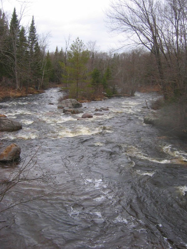
This is a nice section. It starts with 100 yards of rock garden, then 2.0 miles of very flat, windy water with great views. At 2.0 miles, the water starts to move. About a half mile later you will get your first significant drop. Scout all horizon lines from this point on.
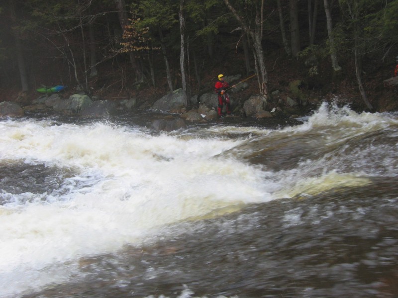
When you get to the last drop (2.9 m) above the bridge (3.0 m), we run it on the right, directly into the roostertail at the bottom; it sends you airborne but be careful of hanging up on the boulders 10 yards down.
There is still a big slide (3.1 m) after the bridge. The left is safe but a bumpy ride at lower levels. The right is safe too but wilder, at really high levels watch out. Be careful of a 8-inch piece of rebar/pipe embedded in the rock at the center top of this section. It is visible at lower levers (7 blocks) but not higher levels (5.5 blocks).
The confluence with the Woodhull (~3.3 m) is ahead, below the Woodhull's put-in rapid. [maps.goople.com terrain view mistakenly calls the Woodhull 'Black Creek']
2.8 driving miles one-way if you takeout at the Woodhull takeout lot.
Access point and dividing point between upper and lower run at the bridge just below the dam.
Take-out for this section but also an alternate put-in for the Miracle Mile section downstream.
From the Woodhull River Confluence you can continue on downstream through the Miracle Mile Section.
Jan 8, 2011
First section: 'Little Woodhull Creek1: : II PUTIN' lat=43.4674, lon=-75.0589 into a flat reservoir and putin may be in the middle of the woods.
Second section: 'Little Woodhull Creek2: : III PUTIN' lat=43.455, lon=-75.1525
Apr 11, 2009
There are two sections to this little creek.
--------------------------------------------------------------------------------------------------------------------
First section is from 'Stone Dam Trail' (off North Lake Road) to the dam on Kincaid road. There is a little reservoir above this dam. River miles about 7 miles, (6 on the creek and 1 on the reservoir.) Looking at the topo map, it's flat the first four miles, then gets some gradient, then of course flat again on the reservoir. 8.7 driving miles one-way. There might be access on some of the smaller roads.
--------------------------------------------------------------------------------------------------------------------
Second section is from the dam on Kincaid Road, all the way to where it dumps into the Woodhull. --
This is a nice section. It starts with 100 yards of rock garden, then 2.0 miles of very flat, windy water with great views. At 2.0 miles, the water starts to move. About a half mile later you will get your first significant drop. Scout all horizon lines from this point on. -- When you get to the last drop (2.9 m) above the bridge (3.0 m), we run it on the right, _directly_ into the roostertail at the bottom; it sends you airborne but be careful of hanging up on the boulders 10 yards down. --
There is still a big slide (3.1 m) after the bridge. The left is safe but a bumpy ride at lower levels. The right is safe too but wilder, at really high levels watch out. BE CAREFUL of a 8-inch piece of rebar/pipe embedded in the rock at the center top of this section. It is visible at lower levers (7 blocks) but not higher levels (5.5 blocks).
The confluence with the Woodhull (~3.3 m) is ahead, below the Woodhull's put-in rapid. [maps.goople.com terrain view mistakenly calls the Woodhull 'Black Creek'] 2.8 driving miles one-way if you takeout at the Woodhull takeout lot.