Trip Reports
Log in to add a reportAB
Adrian Bout
Aug 14, 2006
Class II-IV (VI)
Fish Creek should be 2.5 steady for a minimum here, rising would be cool too. Sandy Creek should also be 2.5’ steady or rising.
Take out at DEC fishing access parking lot on Harvester Mill Road (near bridge over North Branch Salmon River)
7.5 miles from Little John Road
3.0 miles from Otto Mills Road
Description from Castor Hill / Little John Road (private/posted)
Ask the Mad River Hunting Club for access, then…
Run the left tube under the “bridge”. Watch for a small hole in the tube and boof out the end.
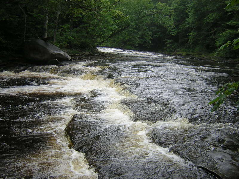
River channels and splits a lot for about the next 3 miles, class II+. Watch for sweet surfing holes and the occasional cable crossing.
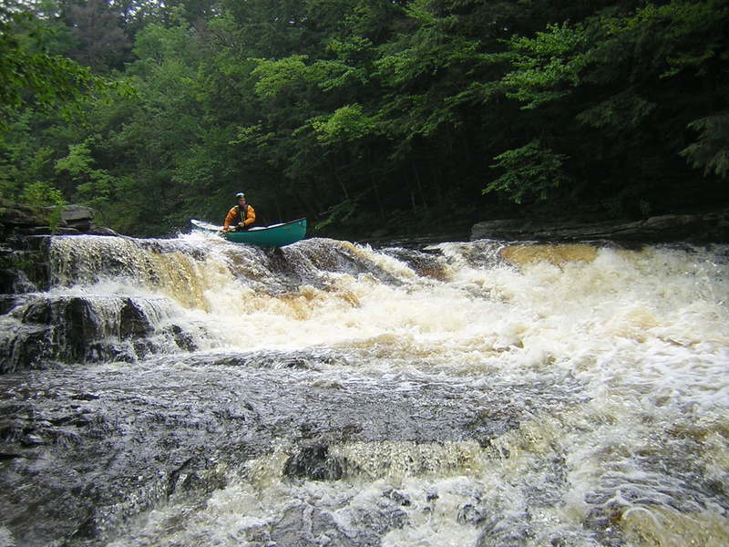
Action pick’s up at Cable Slide (cable crosses right before class III slide).
Best run is down the center, aim for rooster tail and boof the hole.
Two streams converge shortly after, within sight of the eddy after Cable Slide and small gorge walls begin to form.
Its also class II into III waves and holes from here to Otto Mill Falls.
Approx. 200 yards below the Cable Slide is Cold Stream coming in from the left. At good levels the class III ledges of its exit into the Mad is fun to run. Try a short hike up to at least the walk bridge nearby and over the ledges back into the Mad. A great surf/hole also exists at the confluence.
100 yards after this is Rat Brook, comes in from river right. Not runnable but there are play spots in this stretch.
A couple hundred yards after this the river bends left, watch out for the undercut on the outside corner (river right). The inside corner has a small ledge drop, the middle is waves/holes. You also may see a house/building on river right, this means Otto Mill Falls are close.
Once river straightens out there will be some wave trains but take out at one of two truck sized eddy’s on river right. Scout Otto Mills Falls downstream, class IV. Recommend taking out at the first eddy on right. After it, the river forms a fast black tongue that leads over the drops. Our line was to move out of the first eddy and into the tongue, but turn back into the second eddy just before the drop. We didn’t run the center of the first ledge because of an unexplained kick of water (stick, flake?) in the strongest flow. Paddling out the back of this eddy puts you in plenty of water over the 1st ledge and toward center for the second. The second ledge of the drop happens really quick and with some spray so just keep it straight. Much flow heads river left and then falls over the ledge, I’d like to figure out a line to run that sometime.
Your now in a small gorge and will shortly head under a cable suspension bridge. The logging road that crosses the river after it is the extension of Otto Mills Road. You’ve gone approx. 4.5 miles and have 3.0 to go. In this stretch by the suspension bridge is some fun rapids that lead to Stadium Ledge.
Stadium ledge (class III+) felt a bit bigger than when I scouted it a week earlier. It’s a great 3’ boof. This may be the only pool drop on the river, run it almost anywhere. I imagine at higher water a low-head could form here.
The gorge walls will pick up again here and lead thru a couple twists. When you happen upon an island in a straight stretch, keep river right and prepare to get out and portage Mad River Falls.
Mad River falls is about 20+ feet tall and slams onto bed-rock. Its class VI which is a bummer because the lead up is cherry. Be courteous of the cabin near these falls. Unless you want to hike a ways, it will be easiest to rappel your boat down the short cliff on river right, slightly around the bend. You can climb down easy, but not with your boat.
At the base of the falls you’ll be in a sweet little gorge with consistent rapids to run out.
When starting one of the slide like rapids watch for an undercut on river left. You probably won’t get near it, but when you see it ahead, watch the rapid your entering. A dog-leg break in the bed rock near center of this rapids end could cause an abrupt stop…basically just don’t run this sideways looking to surf something.
As the gorge runs out look for a tall beautiful waterfall in the woods toward river left (not runnable). Once exiting the gorge you’ll also come to a part called Horse Shoe Bend. This is marked by sharp curve left with a steep clay, earth and rock slide on the outside corner. This was badly undercut but avoidable.
After Horse Shoe Bend you’ll find the ugly finish of the run and possible reason for Dennis Squires two star rating. The river flattens and channels a lot and becomes jammed in many places with strainers. Be prepared to carry several.
You know your out of the trees once the Mad converges with the North Branch Salmon and becomes “normal” again. Take out is a couple minutes away.
Take out is on river right just upstream of the bridge for Harvester Mill road. Parking should’ve been excellent at the DEC fishing access area.
-Adrian VandenBout
AB
Adrian Bout
Jul 9, 2006
two sucsessive 5'+ drops, this is the first. both are part slide, part ledge. this is basically the ramp that sends you flying off the second ledge.
i saw no sign of an old mill but this place is named Otto Mills on maps, there was a cottage nearby.
20+ tall, the feature to portage. do so on river right, around the bend in the cliff is a good spot. repel your boat with a throw bag, then climb down after it.
as soon as the river quits channeling, another cable crossing apears, with a class III slide following (uh, hence the rapid name). middle looked best, aim for the small rooster tail that'll set you to boof the hole (as pictured).
this is the Cold River as it enters the Mad. there was a walk bridge shortly upstream on the Cold. above this the river came in small rapids from two forks.
you can run this even faster if you start center/left (main flow). it still finished like a blur starting from the river right eddy and peeling out the back of it. its the steroidal class IV version of double-drop on Flint Creek. not bad for the one class IV on this river, just be aware there is a house near river right.
AB
Adrian Bout
Jul 2, 2006
Hans was trying to get me to run this some day. it actually looked really active and runnable in spring and/or heavy rain. drains from same watershed as the Fish.
Ha! i ran this a week later...
these type rapids occured frequently.
this is the largest drop on this section. its approx. 20 feet tall and lands on slab...also the only must-portage on this river.
when portaging, be kind to the owners of the nearby cabin and posted land.
a class III ledge on the Mad. multi tier and shaped like a horse-shoe, i called it Stadium Ledge.