| Difficulty | II-IV(V+) |
| Length | 15.2 mi |
| Avg Gradient | 23 fpm |
| Gauge | Middle Fk American R Nr Oxbow Ph |
| Flow Rate as of 21 days | 390 cfsstale data |
| Reach Info Last Updated | August 7, 2025 |
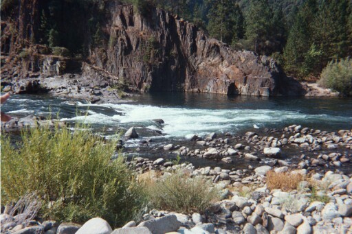
This is a popular summer and fall rafting river since it has dependable daily flows from Oxbow powerhouse. It is usually done in a day, but it also makes a nice overnight trip, giving time to explore the many interesting side canyons and relics from mining days.
Overnight camping permits are required, and as of June 2015, it is legal to camp year round.
http://www.americanwhitewater.org/content/Article/view/articleid/32353/
Camping is permited in the following areas on the Middle Fork American:
· Volcano Creek to Big Snyder Gulch
· Gas Canyon to Browns Bar
Contact Auburn State Recreation Area Whitewater Recreation Office: (530) 823-4162
CA State Parks Gold Fields District Office: (916) 988-0205
Each summer runners competing in the Western States 100 Mile Endurance Run and Riders competing in The Tevis Cup cross the Middle Fork American River at Ruck-a-Chucky Campground (Drivers Flat Take-Out). To facilitate these events scheduled releases are typicaly earlier in the day and Drivers Flat Road may be closed.
For the dates of these events see the respective websites:
Western States 100 http://www.wser.org/
The Tevis Cup http://www.teviscup.org/
Two dangerous rapids stand out. Tunnel chute is a steep jagged man made channel leading to a calm float through a tunnel in the hillside. Ruck-a Chucky is a difficult portage around a big boulder jumble.
Putin: Indian Bar Rafting Acess https://maps.app.goo.gl/qwj4cbVV7uGiWf319
Other Information Sources:
Class V Love, by Mark
...
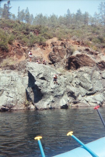
Put-in on the Middle Fork is just below the Oxbow Powerhouse penstock. This results in a cold wake-up call as the abruptness of this irregular rapid with swirly mid-40s August water slaps you in the face.

Fun rapid following a sweeping right hand bend
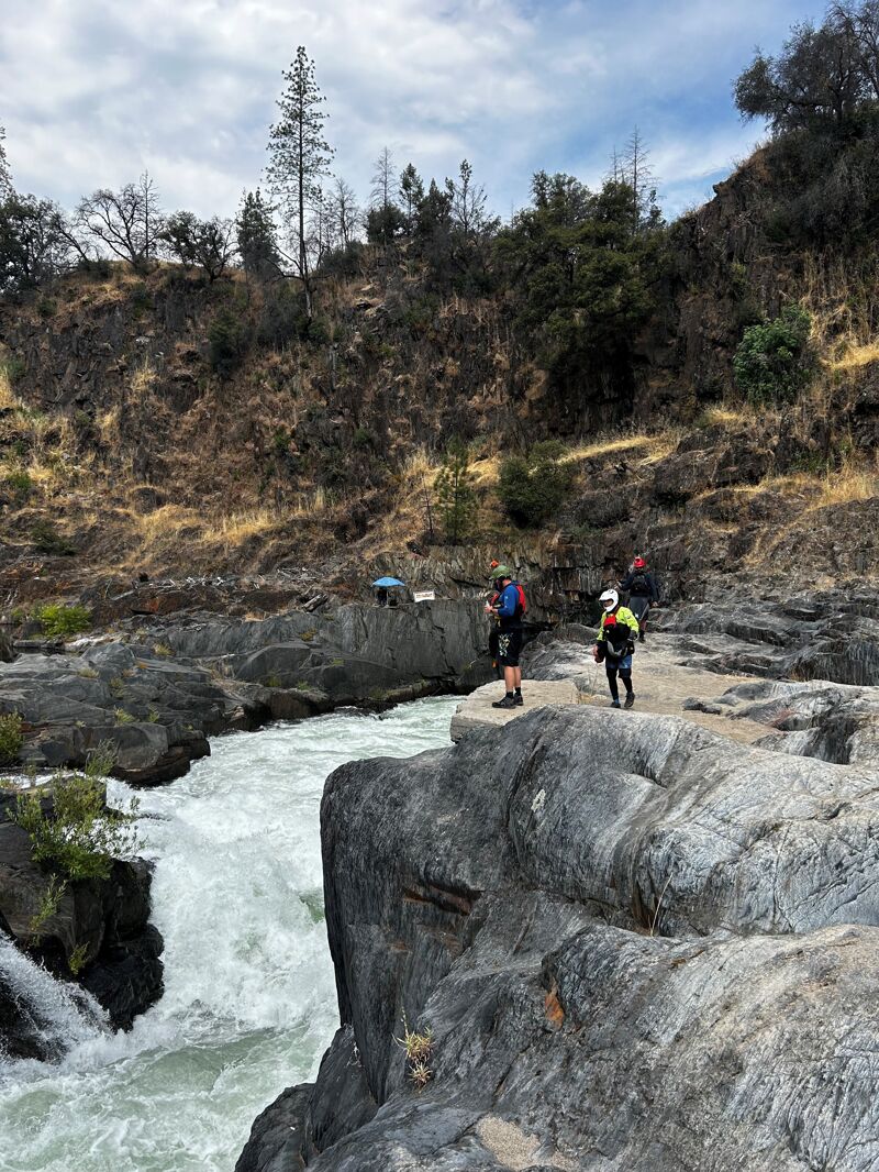
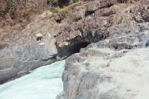
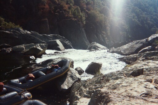
Last Chance is a sticky hole you want to run clean. Just downstream is Tunnel Chute. Scout both Last Chance and Tunnel Chute on river right. There is a big eddy and obvious cobble stone beach. (private land please be respectful)
If you elect to portage Tunnel Chute, eddy out on river left immediately below Last Chance. Above 2000 cfs; according to Cassady, Cross, and Calhoun; its very difficult or impossible to put on below the chute just in front of the 90' long tunnel blasted by gold miners that gives the rapid its name.
Stay to the right to ride the chute, or go left if you choose to portage. Warning: Above 2000 cfs, it becomes very difficult to put back on after bypassing Tunnel Chute because the distance is short between the bottom of the rapid and 90' Rock Tunnel and at that level the water on the left bank is very turbulent at the bottom of the rock wall you need to descend to get to the river. (See pictures below.)
Rather gnarly Class IV - V. Most opt for the right side and ride the chute.
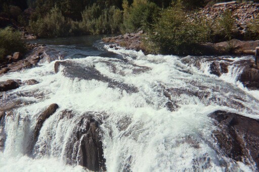
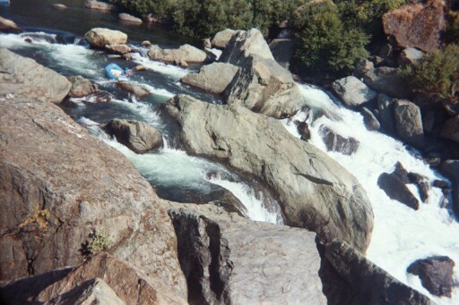
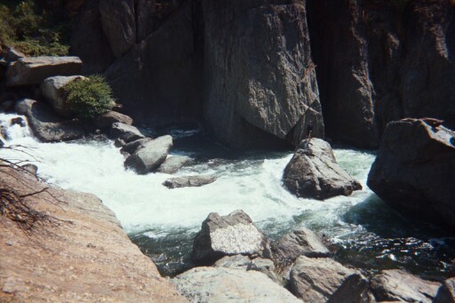
Tunnel Chute is a violent narrow steep chasm the entire river flows through. Immediately below the chute is a 90' long calm rock tunnel that gives the rapid its name. Blasted by gold miners, the chute leading to the tunnel has sharp sides that can damage rafts, kayaks, and people. River right is a vertical rock wall. River left is waterfall that runs the entire length of the chute. Swimming here may be just a quick flush down the center of the chute, but it easily could result in injuries if a swimmer is pounded against the rock wall on the right, or perhaps a deeper and longer experience if the swimmer gets caught in the holes at the bottom of the falls on river left.
At the bottom of the chute, the rapid becomes analagous to the 'It's A Small World' Ride at DisneyWorld...or at least it seems that way after the adrenaline rush of the Chute. This picture gives some idea of the rock wall on the left bank, so if Tunnel Chute is portaged and you try to put back on below the chute prior to the tunnel, you can get an idea of the difficulty--especially when the water is above 2000 cfs and this water remains quite turbulent.
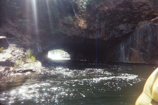
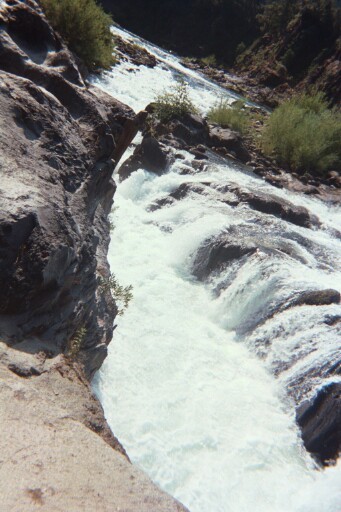
Emerging from the Tunnel, looking back through it at the left wall of Tunnel Chute.
Enter right and move left to the center of the river channel.
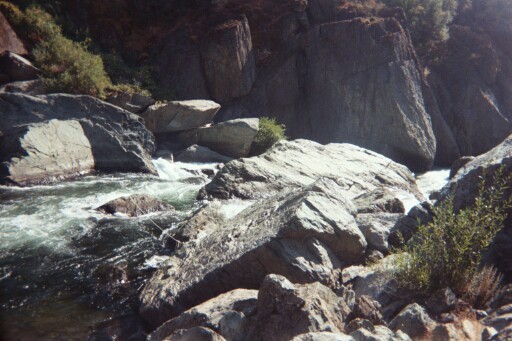
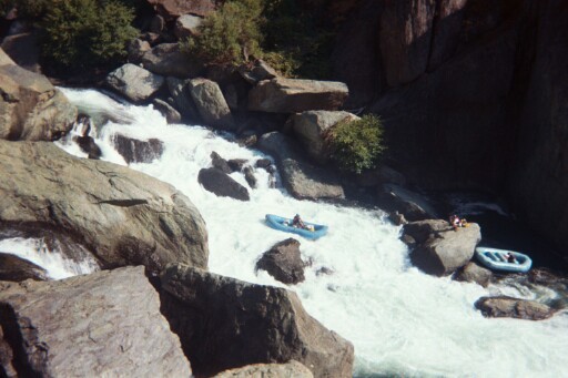
Kanaka is a fun rapid that western boaters say is similar to Sunderland's Chute on the Tuolumne; and eastern boaters say it's similar to but not as difficult as Insignificant on the Upper Gauley. Having run both, I'd say it's more like Sunderland's Chute. At the end of a pool, the river drops pretty steeply. Like Insignificant, there are a couple of big holes obstructing the channel, but they are nowhere near the same scale as that 5.0 behemoth. Unlike Insignificant, Kanaka is pretty much a short straight run once you are lined up and the reversals are evident from the top. Scout and portage on the left.
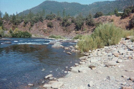
After Kanaka, the river changes in character and flattens out. From here until Chunder it's easy Class I and II in a spectacular forest green river canyon. Spattered throughout this section are active miner rigs with divers along the river bottom, geologic faults in the rock walls, and numerous places for side hikes, sunning beaches, and places to pick wild blackberries. Wildlife includes deer, eagles, hawks, ducks, and rattlesnakes, so be careful along the banks. Bear have been sited in the canyon, but are rare.
A very bad 4-wheel drive road used mainly by miners leads from the left bank to Volcanoville.
A rough dirt roads leads downstream from here to the Greenwood Bridge site and better roads out of the canyon. If your 4WD vehicle is up to it, and if the road is open, you can avoid portages at Chunder, Ruck-A-Chucky, and the next two miles of Class IV by taking out here.
Chunder is a straightforward Class IV ledge drop. However, 80 yards downstream of Chunder is Ruck-A-Chucky Falls--a 30' Class V+ to VI waterfall. The right side of Ruck-A-Chucky is a Boulder Sieve that is very fatal. If the crash into the boulders at the bottom doesn't kill you, the recirculating hole with the water crashing down on you will. Most rafts run Chunder and give paddlers the opportunity to walk-around. A swim here is easy as a pool separates Chunder from Ruck-A-Chucky, but urgent nonetheless. If you are not prepared to run Ruck-A-Chucky and you think that Chunder might give you trouble, PORTAGE on river right.
This picture shows the view looking downstream at the Ruck-A-Chucky Falls horizon line. WARNING: The right side is a Boulder Sieve Death Trap that has claimed lives, kayaks, and rafts. The 30' middle channel drop is Class V+ and runnable in a raft. The left side (not visible)is Class VI and should not be attempted. Please note, while the Middle Channel is now run regularly by raft guides from some companies, there are submerged boulders at the bottom of the drop and many severely undercut rocks. A swim here would be long, deep, and potentially highly injurious. Portage on River Right.
The right channel of Ruck-A-Chucky Falls is a boulder sieve death trap. But it's also a hazard for rafts. Most companies require their guides to push the rafts over the 30' drop. However, if a raft went over the right side, it would be a major project to extract the raft, and even then, in all liklihood the raft would be severely damaged. So there is a rope guarding the right channel, and when raft guides push the rafts over the falls, one of the guides mans the rope guard and tries to prevent the rafts from going down the right side by pushing the raft into the main current. Here, Sasha from All Outdoors Whitewater Rafting (see link on top right of this page) performs that function. Guides from some companies actually run the Middle Channel after they have unloaded their guests, but the Middle Channel is Class V+. The bottom of the falls are boiling and there are many submerged rock hazards. A swim here would be long, deep, and could easily result in a severe injury.
Excellent view of all 3 channels at the Top of Ruck-A-Chucky while a Tributary Whitewater Tours guide (see link at top right of this page) sets up to run the Class V+ Middle Channel. To the left of the raft in the top of the photo is the entrance to the Class VI left channel characterized by being obstructed with huge boulders all the way down. The middle channel, that the raft is about to run, is relatively free of obstructions, but at the bottom are submerged boulders and severely undercut rocks. A swim here would be long, deep, and quite possibly injurious. On river right (foreground) is the entrance to the Boulder Sieve Death Trap that you must avoid at all costs.
At the top of the photo is a good view of the boulder choked left channel. Middle of the photo is an obstructed view of the middle channel, and at the bottom of the photo is the right channel--boulder sieve death trap. The Tributary raft at the bottom just successfully ran the Middle Channel.
Looking upstream at Ruck-A-Chucky Falls, you can see the Boulder Sieve on river right, the turbulent main channel run by some raft-company guides--but not in kayaks--and the rocky left channel. There are many submerged rocks at the bottom of the falls and a swim here would be long and deep.
Cleavage is a 6' drop only 20 feet from the bottom of Ruck-A-Chucky. Run the narrow chute right down the center and then move left. The right side of the photo shows the Cleavage Horizon Line from upstream.
In some ways very similar to Double Pencil Sharpener on the Upper Youghiogheny, but a little steeper and elongated. Enter the rapid as if you were parallel parking a car facing the left river bank, ride the slide and move right.
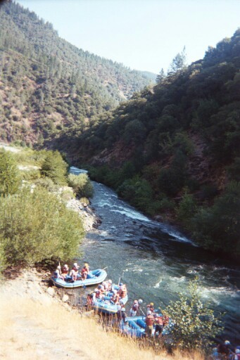
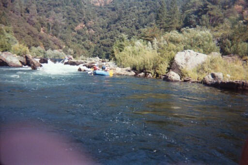
A couple more Class IVs, including Driver's Ed, Catapult, and Shareen's Dream, and then easy Class II to the takeout. Here, raft mates float towards the takeout.
This is the site of Greenwood Bridge, which was washed out when Hell Hole Dam gave way in 1964. Primitive campsite on the right. Driver's Flat Road leads out of the canyon.
Jul 13, 2024
I got a group together to run this in kayaks this past Saturday at the normal 1100 cfs releases. With the gracious help of my wife, we were able to set shuttle to eliminate the normally 2 hour roundtrip at the end of the day to retrieve vehicles.
This was most of the group's first time boating this run. I would classify most of us as Class IV/IV- boaters, with a V leader. We scouted Tunnel on river right, and Kanaka on river left. Tunnel was relatively straightforward with all of us staying upright and punching the last wave hole. Kanaka went more or less ok, with some of us boofing the big hole center, and some going left of the hole.
The 9 miles or so of flatwater in the middle of the run was somewhat pleasant, though really flat near the end. We put on at 11am and were off the river by 4pm.
Overall, there were about 5-7 good memorable rapids with lots of scenic flatwater in the middle. If you were to make a day of it (pack a lunch, stop to hang out etc), it's about a once a year run for me, when nothing else is flowing.
Aug 2, 2002
After running the turbulent chute, the rapid mellows into a nice slow float through a 90' tunnel carved by California Gold Miners. It's rather reminiscent in it's calm of Disney's 'It's a Small World' ride...or at least it seems that way in contrast to the adrenaline rush of the Chute.
80 yards downstream of Chunder is Ruck-A-Chucky Falls--a 30' Class V+ to VI waterfall. The right side of Ruck-A-Chucky is a Boulder Sieve that is very fatal. If the crash into the boulders at the bottom doesn't kill you, the recirculating hole with the water crashing down on you will. If you are not prepared to run Ruck-A-Chucky and you think that Chunder will give you trouble, PORTAGE on river right.
Just an easy Class III hole, but you want to make sure you're in control after Last Chance so you can enter Tunnel Chute right on line. Consequences of being off line in Tunnel Chute include a turbulent ride bouncing off of a vertical rock wall on River Right or a trashing in the holes at the bottom of the waterfall on river left.
Rather gnarly. Avoid the Left Entrance, opt for the right side and ride the chute.
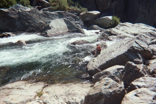
Immediately downstream of Tunnel Chute, the river is calm and gives an opportunity to reflect on what a rush running Tunnel Chute gives you.
Avoid the Boulder Sieve at Ruck-A-Chucky Falls on River Right at all costs. The right channel drops 20 feet into a boulder sieve. If the fall doesn't kill or seriously injure you, the pounding water from above or the keeper hole at the bottom will.
Looking upstream at Ruck-A-Chucky Falls, you can see the Boulder Sieve on river right, the turbulent main channel run by some raft-company guides--but not in kayaks--and the rocky left channel. There are many submerged rocks at the bottom of the falls and a swim here would be long and deep.
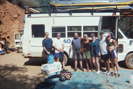
Sasha is in the Green Lotus River Shorts, the photographer is in the NRS hydroskin shirt and IR shorts. The rest of the crew, celebrating with a surprise birthday raft trip on the Middle Fork gathers around the AO shuttle bus.
The right channel of Ruck-A-Chucky Falls is a boulder sieve death trap. But it's also a hazard for rafts. Most companies require their guides to push the rafts over the 30' drop. However, if a raft went over the right side, it would be a major project to extract the raft, and even then, in all liklihood the raft would be severely damaged. So there is a rope guarding the right channel, and when raft guides push the rafts over the falls, one of the guides mans the rope guard and tries to prevent the rafts from going down the right side by pushing the raft into the main current. Here, Sasha performs that function.
Guides from some companies actually run the Middle Channel after they have unloaded their guests, but the Middle Channel is Class V+. The bottom of the falls are boiling and there are many submerged rock hazards. A swim here would be long, deep, and could easily result in a severe injury.
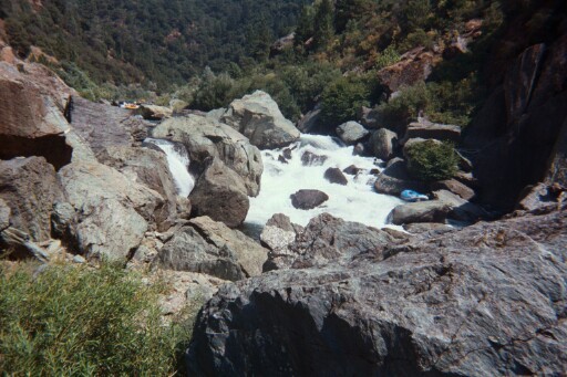
Strange angle shot from river right bank gives you a view of the entire rapid. At the very top of the frame is Last Chance Rapid. At top right is a big pool that flows around and becomes the left entrance of the Chute and falls into the chute over the Rapid-long waterfall. The left side of the frame (river right) is the vertical rock wall. Swims here are usually fast and violent as swimmers are flushed out of the chute. However, river rash is not unheard of after collisions with the rock wall on river right, or sometimes prolonged in the holes at the bottom of the waterfall if a swimmer strays river left.
This picture shows the view looking downstream at the Ruck-A-Chucky Falls horizon line. WARNING: The right side is a Boulder Sieve Death Trap. The middle channel is Class V+ and runnable in a raft. The left side is Class VI. Portage on River Right.