Trip Reports
Log in to add a reportCK
Cameron Klinger
Sep 11, 2011
A group of us ran this on 09/09/2011.
The level at Rondout Cr near Lowes Corner was 650 cfs / 1.89’. This was a low but runnable level.
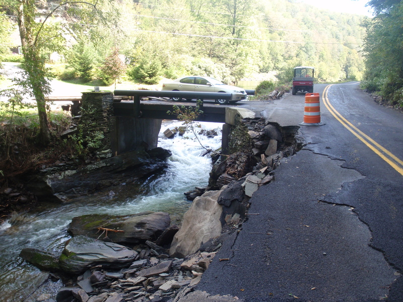
Hurricane Irene and Tropical Storm Lee have turned this river into a mess. The shuttle road had one lane washed out in many places. This may cause access issues while this road is being repaired. There were many trees in the river and we encountered 5 required portages. Other rapids had trees in most of the flow. Despite all this, the run was completely worth dealing with the extra wood. This river was very scenic and had many beautiful waterfalls dropping in from the sides. It also had a very remote feel even though the road was not far away.
CK
Cameron Klinger
Sep 11, 2011
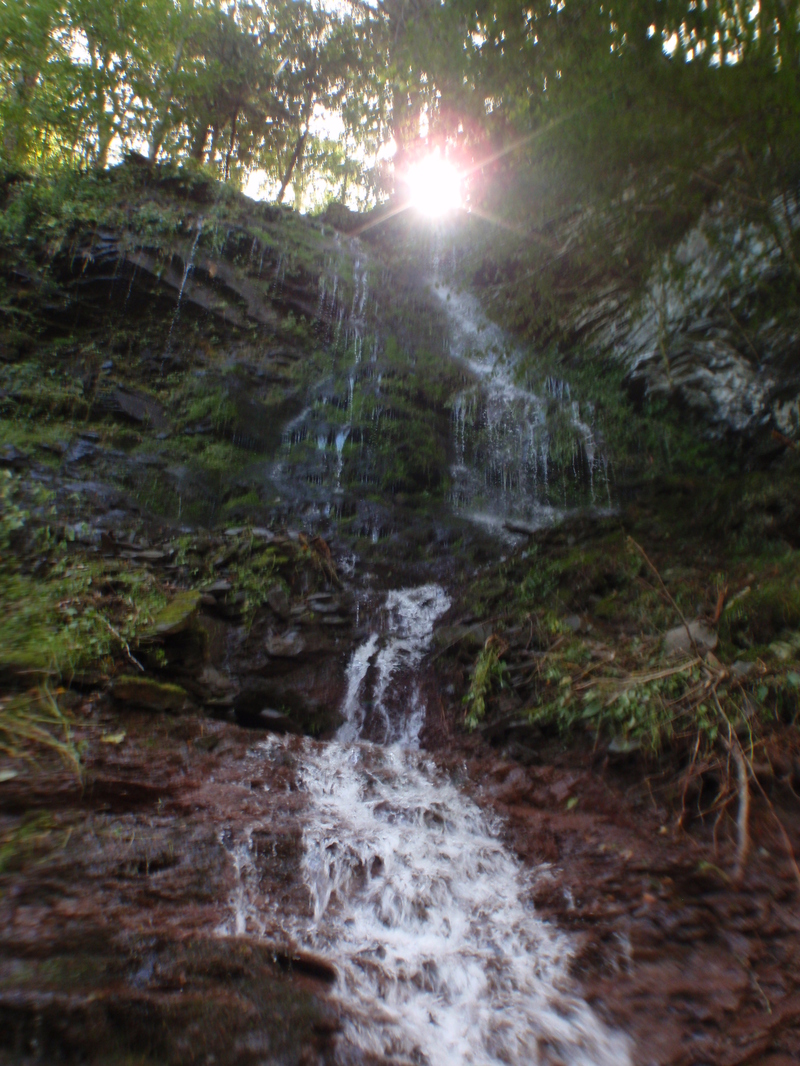
There are many beautiful waterfalls (on the sides of the river) in this section.
CK
Cameron Klinger
Sep 11, 2011
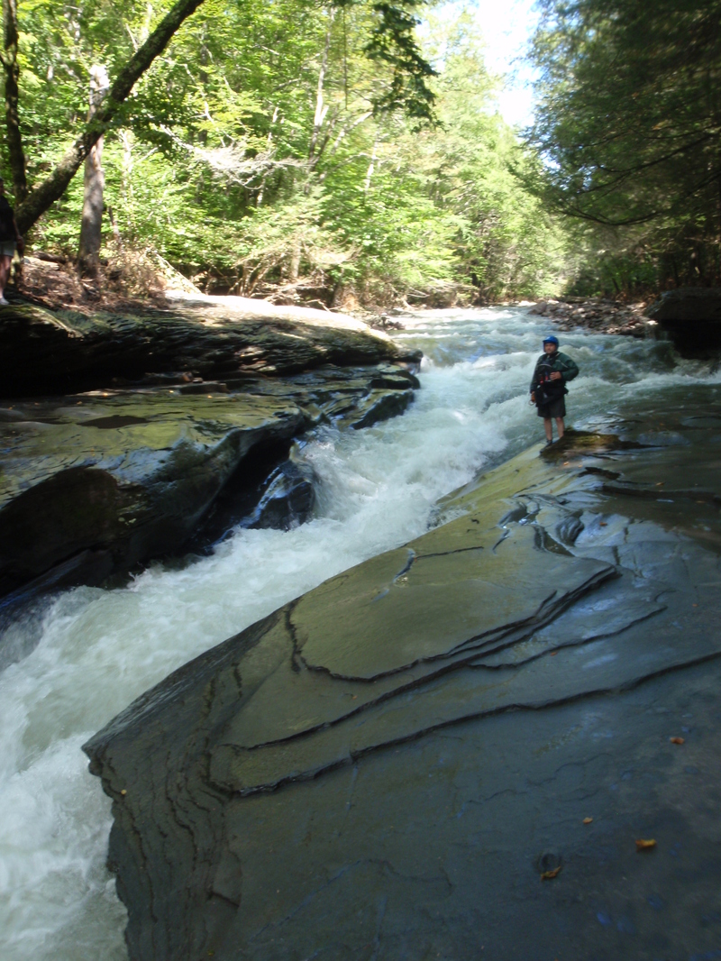
This is the most difficult rapid in this section. It is a slot move not much wider than a kayak. It can easily be scouted or portaged.
CK
Cameron Klinger
Sep 11, 2011
Hurricane Irene and Tropical Storm Lee (Summer 2011) washed out one lane of the shuttle road in several places. This may cause access problems as this road is repaired.
LM
Linda McLuckie
Sep 10, 2011
The listed gauge was discontinued about a year ago. The next gauge downstream ( http://waterdata.usgs.gov/ny/nwis/uv/?site\_no=01365000&PARAmeter\_cd=00065,00060 ) is at Lowes Corners. It includes flow from another stream and won't correlate perfectly with the old gauge, but figure 600 CFS is about minimum.
JD
James Dougherty
Dec 2, 2007
I decided to add this since what was here was less than useful. Better info to come when I better understand how to use the 'tools' provided by AW and when I become more intimate with a creek I consider a gem.
First off, I listed it as 6.5. This is if you take out in Sundown but I'm not sure of the parking situation there. Driving north on rte 42, peekamoose road from Sundown and probably a bit less than two miles you'll see an offical spot. Using this parking spot shortens your paddle to about 4 miles and probably the best part. There are many places for parking since you are what is know as Sundown Wild Forest and further up Sundown Wild Forest on your right (south) and Slide Mountain Wilderness Area on your left (north). Go as far as you are still on State land before you see posted signs, mabe a mile passed Buttermilk falls which will be on your left.
Here's a little I can tell you. I was up there on 11/12/07 and nothing was running. The Beerkill/West Beerkill under rte 209 was really low but the Upper Roundout I could have hucked down although with much scraping, getting stuck and cursing with periods of joy. This leads me to believe it may run when other things are not. Another thing about this is although you are along side a road, on a weekday there's bearly any traffic (although on nice day weekdays there will probably be a lot of hikers) and it is incredibly beautiful. When you come here, it will remind you nothing of Roundout river in Rosendale which comes after the Reservoir. This upper section is a true creek, narrow channel and a very fair amount of gradient.
Word of caution: I have not seen it at high water but I imagine this can easily become a CL4. The good thing is you can scout the whole thing from your car and getting out a few times to get a better look.
Bonus: If your not sure it will be up bring along your daypack. There's excellent hiking. You can hike up to peekamoose, 3.90 miles which reaches 3,847 ft or run a shuttle and park the 'take out' car at the north end of Denning road to make for almost a 9 mile hike. When we went up, there were patches of snow where we started but a good 2 and a half inches up at the top.
If there isnt enough rain but you wish to scout bring your non-paddling better half with you. She/he would probably enjoy the scenery. They're bound to enjoy Buttermilk falls, which is not the Roundout but a tributary, Buttermilk Falls Brook. Also, there's a spot on the Roundout it self called 'blue hole' by locals.I think it's just upstream from Buttermilk falls, it will be on your right if driving north. This is where the Roundout all of the sudden becomes 20 to 30 ft and it's sort of a jade/blue in color and you can see the bottom making me believe this creek must be really clean. Looks like it would be a great place to swim (although cold I bet) in the summer.