Sacandaga, Middle Branch
Christine Falls to East Branch

| Difficulty | III-V+ |
| Length | 7.6 mi |
| Avg Gradient | n/a |
| Gauge | Sacandaga River Near Hope Ny |
| Flow Rate as of 1 hour | 86 cfsbelow recommended |
| Reach Info Last Updated | February 15, 2026 |
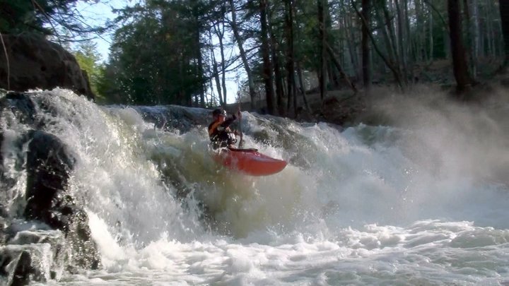
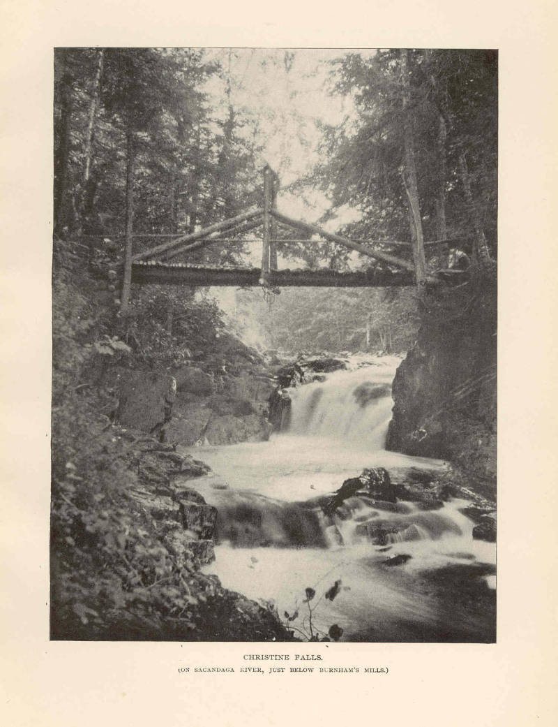
The Middle is a great run when everything else has dropped after a long amount of rain. It holds water from the two big slow-draining lakes and still cranks class V rapids when everything else is back to low levels. Put in at the Old Rte. 30 bridge upstream from Christine Falls or just start at or below Christine Falls (you need a lot of water coming over the dam to flirt with Christine). Do not trespass on or around the dam. Finding a starting spot below the dam when the water is high is very tricky. Creative seal starts work. Be careful of the undercut left wall at the bottom of the drop.
Run Christine's Revenge (just downstream - finishing at the powerhouse). Revenge is about a 10' falls on the right and a bumpy slide on the left. At high water the hole below the falls can be very frothy and retentive; you may opt for the left slide.
Boogie water to Roadside Falls (when low, run the slide/slot right; when high, go for the big-air boof left and stay out of the hole). Get some video action here.
A bunch of boat-scoutable horizon lines and fun slides & more boogie water take you to the flatwater before Austin Falls.
When you see the rapids forming again, get out and scout on the left, using the old road. The upper section is a powerful slide (V) with undercut/pinning rocks on the right. You can run the lower IV+ section into the big curly tube or waterfall - depending on if it is low or medium. The Groove Tube (at low-medium water) is a very unique river feature that is fun to paddle right into and emerge airborne on when coming out the other side. High water is dangerous, fast and powerful V+--not recommended. The Class-IV runout of Austin below the Groove Tube is a great series of slides and boulder drops. Mellow class II brings you to the old bridge (optional takeout) or blast through 2 miles of flatwater to the class-III entrance to Auger (VI).
Take out right before Scr
...The Christine Falls hydropower project (FERC P-4639) is served by the Christine Falls Dam, a 15-foot-high, 152.6-foot-long concrete gravity structure located on the Sacandaga River.

Big drop below the dam that requires a good amount of water.
The Christine Falls Hydroelectric Plant (FERC P-4639) is a small power station on the Sacandaga River. The first hydroelectric development at the falls dates back to around 1927, when a local utility built a dam and powerhouse that operated until the early 1950s. That original facility was later abandoned. The current Christine Falls project restored hydropower at the site and began commercial operation on April 15, 1988 under a Federal Energy Regulatory Commission license. It operates with two turbine‑generator units and has an installed capacity of about 850 kilowatts (0.85 MW), generating a few thousand megawatt‑hours of electricity annually in run‑of‑river mode. American Whitewater was a party to the relicensing of the hydropower project and reached a settlement agreement in 2022 that will improve river flows, recreation access, and provide flow information that supports whitewater boating below the Christine Falls Dam.
An optional access point that can be used as a take-out above Auger Falls.
Oct 29, 2011
The Middle is a great run with a lot of intense action. It is many times good when everything else has dropped after a long amount of rain. It holds water from the two big slow-draining lakes and still cranks class V rapids when everything else is back to low levels. Put-in at the Old Rt. 30 bridge upstream from Christine Falls (V) or just start at or below Christine Falls (you need a lot of water coming over the dam to flirt with Christine. Do not trespass on or around the dam. Finding a starting spot below the dam when the water is high is very tricky. Creative seal starts work. Be careful of the undercut left wall at the bottom of the drop. Run Christine's Revenge (IV+) just downstream - finishing at the powerhouse). Revenge is about a 10' falls on the right and a bumpy slide on the left. At high water the hole below the falls can be very frothy and retentive, you may opt for the left slide. Boogie water to Roadside Falls (IV-IV+) When low, run the slide/slot right, when high go for the big air boof left and stay out of the hole)
Get some video action: (http://www.youtube.com/watch?v=vvvFBhYlKew) or just type in 'Adirondack Whitewater 01' on Youtube.
A bunch of boat-scoutable horizon lines and fun slides & more boogie water take you to the flatwater before Austin Falls. When you see the rapids forming again get out and scout on the left, using the old road. Upper section is a powerful slide (V) with undercut rocks on the right. You can run the lower IV+ section into the big curly tube or waterfall - depending on if it is low or medium. The GROOVE TUBE (at low-medium water) is a very unique river feature that is fun to paddle right into and emerge airborne on when coming out the other side. High water is dangerous, fast and powerful V+, not recommended. Class IV runout of Austin below the GROOVE TUBE is a great series of slides and boulder drops.
Much of the time when the rest of the run is too low, you can still run Austin Falls - just drive down the old abandoned Rt 30 and park at the falls and run laps.
For video action of Austin Falls at low water (without the Groove Tube at the falls) type in Adirondack Whitewater 02 on Youtube or check out:
http://www.youtube.com/watch?v=QkCuoo7XKHU
Mellow class II brings you to the old bridge (optional take out) or blast through 2 miles of flatwater and open old hardwoods to where the forest changes back to hemlocks and pines with the class III entrance to Auger (VI). Take out on right before screaming right hand turn. Carry or die. One boater accidently was swept over the falls and survived by an act of God. The gorge below Auger is V tapering to IV to III to II, finishing in over a mile at the Rt. 8 Bridge. Take out about 200 meters past bridge on left along secondary road. Watch out for poison ivy.