West Canada Creek, S. Branch
Fayle Road to Nobleboro
April 15, 2006
| Reporter | Adrian Bout |
we found one flat stretch in several miles and decided to do a little kayak sledding with the left over snow. Hans was our probe in his canoe, this is Matt Filippelli in an M3.
this is the take-out for WCC Big Brook to rt8 and the South Branch WCC sections. parking and access are excellent. there's also a level dependent wave above the route 8 bridge which can get 30' wide and a couple feet tall.
this is the put-in for WCC's South Branch. park to the right at the base of the dead-end. posted signs everywhere so don't wander into the woods. road signs were very bullet riddled.
it was Matt or Hans who said some places down south they put a case of beer on the hood of the shuttle car to apease locals. we were fine but kept our action discreet none-the-less.
this was what we were looking for! after a mile plus of flat water the river started into many miles of class II-III. its a bit narrower than the main branch.
gage level is only approximate. its many miles down river and below the merge with the main branch, its still a good reference though.
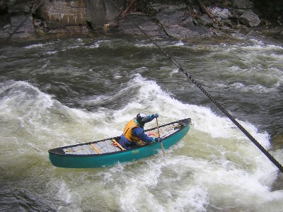
Hans shoots for a wave under a cable crossing (cables are not too low, but marked with large concrete abutments). after this the river gets fast/narrow and produces some large wave holes.
don't be fooled, the flat lasts for just over a mile, but only delays the gradient. the rest of the run has relentless class II and III rapids.
For the full-sized version of this photo, click here.