Trip Reports
Log in to add a reportCW
Curtis Warner
Jul 26, 2017
Just a comment to rafters and inflatable boat captains. About 2/3 of the way down this run, you will come to an old low water bridge. It looks like a river wide ledge with a few cuts in it. These cuts are about 7 to 8 feet wide. The center one is the one I chose to run. On the left side of the center one is iron sticking out that looked sharp enough to let all the air out of a raft. I did not hit it but it could easily be done. If I ever get back on this run, I will take a hammer or saw and fix this problem.
JB
Jeff Bolling
Jun 25, 2017
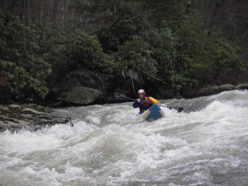
Ran this stretch with a small group for the first time on 6-25-17. Gauge was about 4.2' and falling, so the run was absolutely non-stop, read-and-run. While most of the rapids individually were Class III or III+ moves, the continuous nature of this run made it a real shot of adrenaline at the higher end of this page's recommended levels. Simply put: you wouldn't want to come out of your boat here. There are practically no recovery pools, so keep your crew tight and keep an eye on each other at these levels.
The first major ledge drop was runnable on the far left with a right-left-right move around some pretty big holes. Alternatively, we took an awesome auto-boof about 4 feet off the far right shore. At lower levels, I think you could easily boof the center, but there was probably 7 or 8 feet of backwash off the ledge, which made us collectively decide it was too sticky for our taste.
Terminator is a huge horizon line, and even with having never paddled this, it was clear that something worth scouting was ahead. Scout and walk on the right. Most of our group walked it. The sieve rock described above (where all of the water is pushing) isn't the only issue here: there's about 100 yards of rapid above it, a decently large hole below it, and several more rocks that can bang you up below that. The shredder in our group cleaned it, while the two kayakers both spent time in the hole and took a couple of hard hits on rocks below before eventually getting bow rescues in the short pool below.
We paddled down the flooded Yough (over 10' in Ohiopyle) down to Connellsville, which was about 4-5 more miles on very fast current. Heads up when you get to your first railroad bridge after the confluence: there's a nasty low-head dam that you have portage via the railroad tracks on river right.
This run is totally worth it if you have the right levels and the right crew.
BF
Bruce Fleckenstein
Mar 25, 2012
Running the Big Slide
?
Untitled
May 7, 2009
Robert Farmer---As for the shuttle, the people whom I joined decided to take out at the confluence of Indian Creek and the Youghiogheny River. It's a fairly long shuttle, but it definitely beats walking back up, and you can look at Morgan Run while you're there. The shuttle is a lot faster if you know where you're going, so: From Camp Christian, go north on 381 to Normalville, then west on 711 to Connellsville, then south on 119. Just past the Chevy dealer (which may be a historical relic soon) or where the two directions of 119 come together, there is a traffic light---a brand spanking new, shiny, expensive, lah-dee-dah traffic light. Apparently they used up their whole, entire budget on this traffic light and therefore couldn't afford road signs. Well, if you're not from around there, maybe you just don't need to turn there, could be the thinking. Anyway, on the right, there is a tiny sign behind a bush that says, 'Arch Bridge Road,' or maybe two words, not 3. On the left is Dogwood Road or Lane or something. The road that you want to turn left onto actually has no sign, so I'm not going to guess its name, but it goes through the town of Dunbar. Just try to keep on this main road until it comes to a T-intersection. The sign should say, 'Ohiopyle' to the left. That's your route. After the Dunbar mine and a big grassy area, the road goes up a steep hill. Look for the signs for Camp Carmel. Follow these signs to the left. There is one place where it looks like this side road might turn bad and go straight, or go steeply down a freakin' ridiculous cliff with a pretty good road surface. Keep to the good surface down the hill; it's better than it looks from the top. Follow this road basically down to the Yough, where you'll park next to Morgan Run. Camp Carmel, at the Indian/Yough confluence is @ 1/4 mile downstream (left). Carry your boats back here from the takeout. There was some speculation among the members of our group that shuttling through Ohiopyle might be faster than going through Connellsville. This is wishful thinking. The Camp Carmel turnoff is @ 15 minutes from Ohiopyle and @ 12 minutes from Connellsville; and Connellsville is closer to the put-in. There is an obnoxious traffic light in downtown C.ville where traffic gets stuck as you're driving back to the put-in, but you can circumnavigate it via side streets to the right, if you're more clever than a potato. Much of the time for this shuttle involves narrow and/or dirt roads. It might be better to just paddle into Connellsville, and skip the rustic road rallye event, but whitewater boaters seem to be downright phobic about the thought of paddling flatwater, so I haven't been able to sandbag anyone into trying that route, yet.
?
Untitled
May 7, 2009
Robert Farmer---Well, I happened to catch this with about 2 feet more water than the last time (see below), and it sure felt a lot different! This time, the level was 3.5 at Route 653 (2.8/1500 at Ursina), and it was rather pushy! In fact, at the top, it was kind of intimidating, seeing as how the water was too fast and shallow to get control from the put-in launch spot. Later, there were whirlpools that appeared and disappeared suddenly but which were not deep enough to really do anything bad; they just wanted to mess with us. As the creek got going at the first steep section, the waves were big and pushy. As the creek bends to the right, the first 6-foot ledge appeared after a somewhat flat pooling spot. At 1.8, it had seemed inconsequential, but at 3.5, it seemed quite consequential, you bet! Scout on the right (easy walk). From here down to the pool below Terminator, there are no pools (several miles). Some sections don't even have eddies, or at least not good ones, so in addition to bringing your bombproof roll, just don't flip; there are few hazards, other than long wave trains and the occasional hole and maybe a few logs, but the water is so fast that swimming to shore with your gear will really tire you out. Our group had a few swimmers, and, trust me, it's a whole lot better not to swim. At the second 6-foot ledge, the left side was Class 5-ish, but the popular route (other than portaging, which was fairly popular) was a chute on the far, tight right. Farther downstream, the 3 horsemen of the apocalypse were under water, but there is an island to the right of that undercut left-side bend. I think that this is the only island on the creek, and Terminator is right downstream. At this level, taking out on the right above T. was perfectly easy because the water pools above a ledge; although, with much more water, there might be a tendency to be washed over this ledge. Some people went left, but, for the life of me, I can't understand why. Also, there is an old road about 50 feet from the shore on river right, which makes scouting and portaging Terminator just so-freakin'-easy, even your grandmother could do it. The Indian was quite popular on this day, as about 3 groups converged at Terminator. 4 or 5 people out of about 15+ ran it, including one who, I'm told, swam from very near the top (emphatically not recommended!). We ran 2 different lines: semi-center, and the left sneak (very bumpy-looking). It was a delightful day on a terrific creek. I'd say it was all continuous Class 3 with occasional bits of 4 thrown in sporadically. Remember that there are basically no pools, but, even though there are constant threatening horizon lines, it basically stays pretty much the same difficulty all of the way down, except for Terminator, which is intimidating and potentially hazardous, but not exceptionally technically difficult. This creek should definitely be on your list!!! Scrumptious!
?
Untitled
Apr 23, 2009
Robert Farmer---I caught this at a minimum level the other day. If you were wondering just what the minimum is, I would say it is 1.8 on the Route 653 gauge. (Note: this gauge is on river left upstream of the bridge and has black lettering on dark concrete that makes it almost impossible to see, let alone read.) Laurel Hill was at @ 1.86/350. At this low level, it was all Class 3, with the one Class 5---perfect for your almost-non-paddling-significant-other-in-an-inflatable-kayak-on-a-hot-summer-day. Probably another foot or so would be quite fun and mostly Class 4. The run starts off with a long left bend, then goes into a long right bend; toward the end of this right bend, on the right side, is a hole that is backed by a piece of bedrock from the shore---very sticky at low levels; probably washes out at some point, but watch out. Best to stay left. The streambed for this creek is pretty much all smooth bedrock, with many slides and ledges, but not so many boulder gardens---very interesting. After a while there is a 6-foot ledge; run right (6-foot vertical to a deep pool) or left (short vertical to a right-curving slide) but not center (6-foot vertical to flat rock). Scout Right. It's pretty easy to tell when the crux rapid is coming. You'll come to a right bend with undercut shelves on the left; there are 3 rocks scattered in the way---I thought of them as the 3 horsemen of the apocalypse. Anyway, it turns out not to be hard, but then there is a 3-4-foot ledge just downstream that you might want to scout. From here, you can see up ahead that the 80-foot-wide creek narrows to about 25 feet and acquires some 10-foot shelves for the shorelines---hey, it ain't rocket science; it's easy to figure out! At low water, the line was elegantly straight, though it is always trying to force some turns---very interesting. I cleared the undercut rock by a good 2 feet---18 inches, at least! Plenty of room. Or the carry on the right looks perfectly reasonable. There's a soccer ball jammed in a crack on the bottom left, if you feel like exerting yourself a bit to get it out. One more scout-worthy rapid (clear on the right), and the creek eases off. I walked back up the creek from the confluence, but I really can't recommend this hiking shuttle---it is definitely not 45 minutes, as reported elsewhere! I timed it at one hour and 55 minutes, with no more than 5 minutes of minor pauses; I was walking briskly, although my boat is big and heavy. Of course, you don't really have to go all of the way to the confluence, but I like to do that. Personally, I would rather just do some flat water and a shuttle, but, hey, it's up to you. On another note, 2 young guys discovered that their ATV doesn't float in the creek; yeah, they hiked up to the trail, looking a bit spooked, and asked me if I had a truck! Well, I wouldn't be carrying my boat 4+ freakin' miles uphill if I had a truck, now would I?! I'm thinking that ATVs aren't supposed to be back here, but about 30 of them passed me, perhaps on a rescue mission. The trail is a perfect old railroad grade. When I got home, I got out my folding kayak dolly/trailer thingy, and put it in my car, in case I want to do this one again; it fits nicely in a large boat.
?
Untitled
Mar 27, 2008
Robert Farmer---I looked at this a little bit last weekend. I saw some local guys taking off it. Apparently, the approach is different than the description above. To put-in, turn west off of Route 381 at Camp Christian, a few miles north of the town of Mill Run and 0.2 mile south of the steel truss bridge over Indian Creek Reservoir. Park in the obvious parking lot and walk 1/2 mile to put in below the dam. The local guys whom I saw said that they took out on river left and walked up an old road back to the put-in (@5 miles). There is a gauge at the bridge over Indian Creek at Route 653, just a mile or two north of the steel truss bridge and about a mile east. The first day, the gauge showed 3.5 and looked too high for first-timers (me); the next day, the gauge read 2.75 and looked good, but the day was cold and snowy, so I passed.
PC
Paul Cline
Oct 7, 2005
Indian Creek Water Quality Update 10/7/05 from the Tribune-Review
The water still flows orange in some streams in the Laurel Highlands of Fayette and Westmoreland counties, but if the Mountain Watershed Association has its way, those streams will some day run crystal clear. It's been 11 years since the nonprofit group was formed by a small group of volunteers. Since that time, the organization has managed to bring in more than $4 million in private and government funding for increasingly ambitious environmental projects aimed primarily at cleaning up acid mine drainage in the streams of the Indian Creek Valley in Donegal, Saltlick and Springfield townships.
The group's first project, in 1998, was a $20,000 stream bank stabilization project along Indian Creek in Donegal Township. Since then, the scale of the projects undertaken by the association has grown, along with the cost and the frustration of dealing with government red tape. Today, the association is involved in some of its largest and most expensive undertakings, including the $2.4 million Anna and Steve Gdosky Indian Creek Restoration Project.
Beverly Braverman, executive director of the association, explained that the Gdosky project, also referred to as the Kalp Acid Mine Drainage Treatment Project, is designed to not only treat acid mine drainage from the former Melcroft No. 1 mine, but also to avert a mine pool blowout that could dump millions of gallons of acidic mine water into Indian Creek. The first phase, which involved tapping into a 53 million gallon mine pool that formed when the Melcroft Mine No. 1 was closed and abandoned in 1966, has been completed. The next step is to draw down the pool and then treat the orange mine water using a passive treatment system, made up of a series of ponds to be built on a 10-acre plot of land across Route 711 from where the pool is to be tapped. The treatment system is designed to raise the pH of the mine water to the point where it can be safely drained into Indian Creek. Braverman said the project is a priority, not only because of the environmental threat of the acid mine drainage, but also because of the danger a blowout of the mine pool poses to public safety.
KW
Karl Whipp
Jun 18, 2003
We paddled this creek on Sunday, June 8th, 2003. We caught it at 2.7' on the bridge gauge. I would have liked to have seen at least 3', but 2.7' was good to go. It was free of wood as of this date too. There are countless shoal type rapids with so many side-surf, spin holes its crazy. Definately a playboat run if you dont mind dropping a couple of 6'+ ledges in your playboat. All the ledges are recognized by horizon lines. We ran the first big ledge center right. The second one had a right line and a left boof line. Be sure to take notice of the diagonal hole just downstream on the river left side that feeds directly into a bad undercut with wood sticking out of it. The center line proved to be doable, but if you have no momentum or drop off sideways, yer gonna get munched in the hole below and likely stuck in the curtain (just ask my buddy Adam ;). This ledge is badly back-cut and may form a second hole behind the curtain. If you run the center line, do so with 1:00 angle....not 12:00 and not 2:00....1:00. Lastly is Terminator. There is a clean line all the way down the left side. For those with a real need for adrenaline, run the center line all the way...just be prepared to boof the big hole at the bottom off the rooster tail and for Gods sake, stay away from river right. Its BADLY undercut and the rock sticking out 4/5 of the way through the rapid is not only undercut, but has a bad sieve in it. Overall, fun run of the class II-IV nature. I can see Terminator going class V at high flows. Its visable from the 4-wheel drive road while running shuttle...stop and look at it so you'll recognize it once you're on the river. Terminators lead in looks like the other smaller ledge rapids from above.