Marsh Creek
Cunningham Road near Bus US 15 Southwest of Gettysburg, PA to Harney Road, MD
| Difficulty | II-III |
| Length | 7 mi |
| Avg Gradient | n/a |
| Gauge | Monocacy River at Bridgeport, Md |
| Flow Rate as of 1 hour | 57 cfsbelow recommended |
| Reach Info Last Updated | September 25, 2021 |
Ed Evangelidi shared:
This is a solid intermediate-level stream. Not only do the rapids require some skill but the durn dams require considerable attention. All are runnable but with a significant amount of attention to hydraulics or other problems. One small dam early on is very retentive.
Currently the suggested put-in is at Cunningham Road upstream of Bus. US 15. In the past paddlers used a small campground where Marsh Creek passes Bus. US 15, at which a small fee was charged, but lately, the campground has not been available and it's current status is not known. The Monocacy gauge at Bridgeport the gage for this run. A short take-out is near the intersection of Natural Dam road and Mason-Dixon Road, but parking is limited.
For more information, see Keystone Canoeing by Gertler, E.
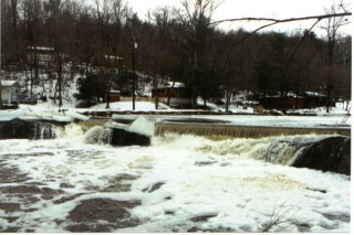
There's a lowhead dam just near the campground. 'Give it some respect,' says Bernie Farmer of the Monocacy Canoe Club.
Plenty of parking on a paved pull out.
Parking is limited at this location - perhaps a couple of cars could be left here.
Jul 31, 2018
A few of us ran Marsh Creek July 24, 2018 from Marsh Creek Road to Mason Dixon Road. The level was 7' on the stick gauge on Marsh Creek at the Mason Dixon road bridge, almost 4,000 cfs on the Monocacy gauge. At this level the run is quite exciting. The section just above Natural Dam is quite continuous class III-IV, chucked full of large retentive holes, boiling eddy lines, and fun wave trains. We ran Natural dam far right next to the bank. At this level several spots open up on the dam and appear runnable. If you run it elsewhere make sure to hit it with speed, get a good boof stroke, and paddle hard at the bottom as the dam forms a very sticky hydraulic. One of our crew ran the 'normal' line on the right and nearly got caught in the hydraulic. If getting on at this level a solid roll is recommended as swims can be fairly difficult and quite hazardous with all of the strainers.
Jun 4, 2012
Use Bridgeport gauge (MD) just downstream - 400 cfs is your zero. [Jug Bridge, 35 miles further downstream and with over 10x the streamflow - gives late and imperfect info.] After Rte 15 comes Harper Hill, a 3-part Cl. III large-boulder rapid - followed by a long pool and then a 2-part Cl. II+ rapid. Next, Natural Dam - ca 3-ft high (on the right) can be run (on the right).
- Alf Cooley
Oct 18, 2009
Just a note--when we ran this today, the campground owner no longer allowed boaters to park at the campground because of liability. Had to choose an alternate put-in at a gravel lot on the right hand side a bit further down Marsh Creek road, but I believe this may have eliminated the first low-head dam and some flatwater. Nice run.
SLD