Saluda
4 - Lake Murray Dam to Broad/Congaree confluence(Saluda Shoals County Park to Senate Street Boat ramp off US #1)
Aug 19, 2012
delete spam links
Dec 16, 2009
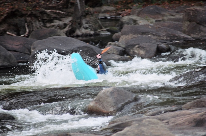
Ran it again, this time at 12,500 on the 5th of DEC. Cookie Monster was in and beautiful! Staceys was in on river right and huge, holes were shallow though. Gervais st wave was in pretty great. It was washed out at 17,000. Blastomatic had some super sticky spots. I got worked for a solid minute and thought about swimming right on down through the monster of Mills Race. Cookie and the massive 9+ ft haystack after it were awesome, not sticky, and totally runnable (they were scary at 17,000). Shipwreck Rock just downstream of Mills on far river left was fun, fast,and retentive just enough to throw a move or two, but not 'loop-able' like 17,000. Shandon also had some decent play..
All in all, 12,500 is a good level, especially for Staceys Ledge wave, Cookie Monster, and Gervais. But as apposed to 17,000, it has ALOT more sticky pourover and ledge holes. Especially Blastomatic and Shandon Rapids. I'd say that Mills Race was a class IV+ with some avoidable Class V on river right, but the main tongue of it is just a bumpy roller coater and a solid Class III boater would not have a problem with it. Shandon had a few spots I'd call 3+. And Blastomatic told me personally that it was a Class IV.
Pray for more rain and subsequent releases!
Nov 12, 2009
The Saluda can be run from the dam all the way to town varies flat and II-III white water - DO NOT run the cascade above the zoo play area unless you:
a: have a death wish
b: really know what you're doing, have a recovery team and paid up life insurance or a really good medical plan, sharp rock, rebar and misc mess from a destroyed dam fill the entire width of the river.
From the dam to town is 4-8 hours depending on motivation and water level. Good play water and fishing along the entire length.
Put in at Saluda Shoals Park and take out at Zoo or portage Zoo Rapids and float through a Cls II rock garden down to the confluence with the Broad and onto the Congaree to the Rosewood (Barney Jordan) boat ramp (another hour or so). My now 15 year old made the trip his first time at age 4 in a two seat Kayak. I've floated it with a troop of Scouts in 18' Grummans, two seat open kayaks, A 16' Explorer and in my own play boat. Every boat type has a slightly different experience but I enjoy it every time.
Dec 6, 2008
Pop up hole is the last rapid that is closest to the Zoo bridge. After you come through mill race there is a short section of flat water (at low water) and then the river narrows down and makes a hole/wave. That is pop up hole.
Nov 24, 2008
is pop up hole the hole right beside the zoo?
Nov 10, 2007
hrowing ends at low water.
Dec 22, 2004
For more information on the Saluda, please visit http://www.saludayakerz.com
May 20, 2003
Saluda stuff
-------------------------------
Some corrections to the names:
Radio Towers is at put-in. At high flows (15,000+) Maytag and Lap of luxury come into play (not rock of luxury :) )
Moshpit=Pop-up, just different names.
The creek currently has some ugly strainers, use caution.
Please note the importance of having a local show you down Millrace the first time, there are places you just DON'T want to be depending on water levels. plus, some more play stuff happens in the top of Millrace on the dreaded right side at up to maybe 3,000 that you
would not want to attempt if you didn't know just where you could and could not be.
There is no mention of the rest of the section. To run the river from the zoo to Gervais:
(class II-II+ (III) if you start below Millrace)
First rapid is Shandon Rapid (III-), .25 mi below Pop-up: as the river splits, take the right fork. Run the rapid on river right. A straight shot, with a
decent hole and a side surfing wave at some levels.
There has been a foot entrapment death here.
River then widens and the Broad joins the Saluda. There is a riverwide shoal type rapid with lots of playable waves and holes. Run just left of the rocks
in the middle of the river.
From here down, read and run easy class II+. There are some more holes etc as you approach the first bridge, nothing scary unless the water is really high. Takeout just past the second bridge (not
counting the zoo bridge) on river left, there is a small beach. Access here may be iffy right now, tread lightly.
This is a good short beginner run. At higher flows most things begin to wash out and some holes form near the bridges. 3 mi. Can be run in an hour or less.
Directions to Gervais takeout from the zoo: get back on I-126 towards Columbia (east). Take the first exit (Huger St.) A mile or so down Huger, turn right on
Gervais St. Just before crossing the bridge, there is a parking lot on the left hand side with a bus stop in
front of it. Park here. Walk to the back corner of the lot, down that street just a bit, and you will see the short take-out trail down to the river.
Apr 14, 2003
http://www.americanwhitewater.org/safety/archive/id/518/
Accident report of a 1998 drowning at millrace
Jan 3, 2003
Gettin' Up!