Trip Reports
Log in to add a reportAL
Adam land
Apr 4, 2016
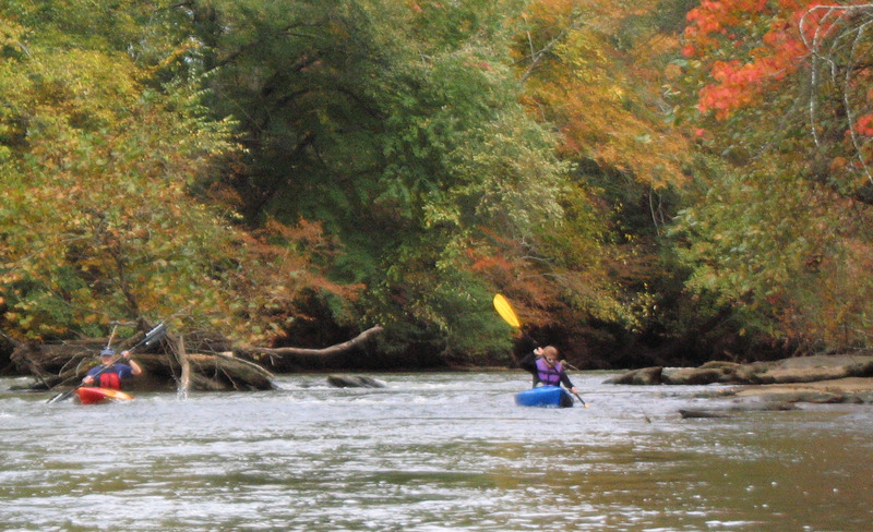
I ran this section from Saluda Dam to Dolly Cooper park on 04-02-16 with a buddy. Dolly Cooper has a nice handicap launch recovery dock. The gauge indicated 3.55. The river was very runable and my GPS indicated the river pushing us at about 2mph without paddling. The only time I bumped any rocks was due to my newness in kayaking and picking a bad line on a couple of the small but fun rapids. This section took about 3 hours with a 30 min lunch break.
GA
Glenn Atkisson
Oct 4, 2013
Ran dam to Hwy 81 today. Gauge (AW#829) shows 3.01 ft at 3 PM. Ran from 1 to 4 PM. Level is low runable because a few scoots needed at top of rapids. Otherwise, level is ideal.
Update as of July 2013 - a takeout along Hwy 81 but way before Piedmont is now at Dolly Cooper Park. Look for the on-river take-out deck, River right. Access to the takeout is off Hwy 81 on Old Anderson Rd., into Dolly Cooper Park. Ignore all the earlier comments now about access via the shopping center. It is fenced off.
Also, Dolly Cooper landing is so superior to anything else in this area, this section should be split by Admin. into 2 sections: 1) Dam to Dolly Cooper which has most of the rapids, and 2) Dolly Cooper to Piedmont which is almost all flat water.
PB
Paul Blichmann
Dec 2, 2011
Went from Old Easley Bridge all the way to Piedmont. 4.0 feet was the level. There was only one ripple the whole voyage - I don't know where 'Class II' is coming from, unless it's in the first mile or two which I left out. It's possible that everything washes over at 4 ft.
Worse was that the river was completely flat for an eternity. I was solo in a long canoe paddling like mad to get in before dark. However I was chasing a Florida-sized egret the whole way, saw lots of ducks, fish jumping, and even beavers. If I went again, it would be with beer and fishing gear...Class I @ 4ft.
GA
Glenn Atkisson
Jan 6, 2011
Gauge read 3.01 at the dam after this run. Water speed is lazy at this depth, but minimal scoots. Water is always dirty looking compared to other SC rivers. Bottom visibility is about 2+ feet.
GA
Glenn Atkisson
Oct 26, 2009
Gauge (AW#829) shows Level at 3.01 ft. at 3 PM. We went from dam to Hwy 81 from 1 PM to 4 PM. No scoots, but can touch or hang at top of maybe 3 of the drops. Otherwise I'd say river level was perfect. I've run on down to Acadia subdivision sometimes when this gauge shows 2.40 to 2.70 and there's lots of scooting in that section at those levels. Try for 2.90 or above.
SH
Sem Holloway
Sep 22, 2009
Ran a short section below the speedway rapid today at 4.9. It is strong at that level. Also, I lost my paddle in exiting. Aluminum and black painted yellow. Please post a response if you find it.
GA
Glenn Atkisson
Aug 31, 2009
Checked gauge before running. My paddle encountered repeated shoals (5-6) too shallow to float anywhere across the stream. I've since run this from the Dam down to same take-out but with other water levels. Don't put-in with gauge (AW#829) reading below 2.90 ft. if you want to use only paddles and want to protect from unusual bottom-wear. If gauge is above 3.20 ft. I would say this is 'runnable'. I've done it with the gauge at 3.46 and would call it 'perfect'.
?
Untitled
Jul 31, 2009
I ran the section from the dam to hwy-81 today. Awesome run for beginners or first time boaters. It was a placid run with very little in the way of rapids. The play spot at hwy-124 was the largest rapid. At 2.70 I had to scoot a time or two but I didn't have to walk. There are many trees down in the river, easily avoided, but a few dozen in all. From now on I will likely take out at 124 due to shallow, dirty, and tree congested waters below 123. In a fast boat with no stops, the run was 2 hours.
?
Untitled
Sep 21, 2008
The access at Hwy 81 has been posted and blocked off. Probrobly due to ignorant rednecks littering the place up. Just across the river, Hwy143 (aka River Rd) hits the river and goes under the Hwy 81 bridge and there is a very steep place to put in.Take out here requires tying a rope to your boat and pulling it up the bank. Worked for me. Good luck all.
KA
Kyle Anderson
Sep 19, 2008
Thursday paddled from Hwy 81 to Piedmont at 2.18 ft. The strip shopping center on river left was very nice and gave us permission to launch. 2.18 ft is the low-end of runable for the first half. Level was not a problem for the last half because the river gets very deep and slow. Almost like paddling on a lake and our lake touring kayaks were fine for this run. Great scenic run but water quality a little sketchy. Kyle A.
RF
Russell Fauver
May 21, 2008
This run is much better broken into sections. I usually go from the dam on Saluda Dam Rd down to Hwy 81. There is a strip shopping center on river left that has public river access and is a great take out spot. If you put in at the dam and take out here this run is about 7 miles and takes 3-1/2hrs. There are several shoals and one set of class II rapids. There are portages on this run and the river flows smoothly at a slow pace the entire stretch.
?
Untitled
Feb 25, 2008
A friend and I ran this section back in January. From Saluda Dam to I-85 is a nice run, with small shoals and moving current. From I-85 to SC 86 is very slow moving, almost like a lake. Also, I double checked the mileage and it is more like 25 miles. It took us over 4 hours of paddling, and that was in Pyranha Speeders paddling hard most of the way.
Tim C