Pigeon
1. Walters Power Plant at Waterville/Big Creek to Hartford Bridge(Pigeon Gorge / The Dirty Bird!)
March 11, 2025
| Reporter | Zachary Whitesell |
| Gauge Reading | 1700 cfs at PIGEON R BL POWER PLANT NR WATERVILLE, NC |
| Flow | Medium Runnable |
Hey friends! Due to the hurricane, the pigeon river has changed quite a bit! I like to think that the river is still a blast! Many new surf holes have popped up, many of the rapids have changed, banks were wiped clean of trees, parts of the interstate have fallen in, there's construction everywhere. Altough it is open and runnable, keep in mind there are places throughout the river where there are pieces of metal on the bank or in the river, and there is no shortage of strainers or trees in river. Most are very avoidble and are very easy to see.
The river has seen a significant change in the appearance of the water, the water is now normally a blue-ish green color and very see through. A lot of the rapids have seen monumental changes. The first mile is inaccessable to the public, duke energy has a one way road meant for just construction vehicles, they have shut down the put in by the power plant. It in is the works to create a new put in at the first mile bridge. There is very limited parking and we have been instructed to be mindful and curtious of the construction crews and rafting compaines. You can park at the AT trail parking, or on tobes creek but keep in mind the bridge is still an active construction zone with giant work trucks driving through and workers walking around throughout the weekdays.
Now as for the rapids, starting at the bridge.
There are new rapids and a nice surf hole right before the bridge. There are two holes at normal flow here, ideally stay center go around the holes and avoid the pylon.
The line going into veggematic can be similar to as it was before, stay right cut left at the bottom. All the rocks through here have moved. Near the end of the right line there is a fun looking pourover with a little drop, you can't see it upstream but behind it is a nasty little rock that'll make you question your life decisions if you hit it.
(As of 3/11/25 there are two trees down on the right side, you'll have to pinball down around it. They are building a construction acess road on the right bank)
At veggematic you can also go to the left now if the water is high enough to cover the rock garden ~1500 cfs. There's a couple of big rocks but generally a nice slant all the way down it. I haven't been this way this much, however I have seen it successfully rafted with a 4 load at 1700cfs, no problems whatsoever. Looked really fun and splashy.
The stretch inbetween veggematic and big bend now has a few new rapids in it as well. The rock you could do the spin move off of is still there. There are two options here, go right around that rock and then get back left around the group of rocks and going back to the right at the end, or go left the entire way and cut back right again. Left line can get shoaly at lower levels but above ~900cfs its a nice ride. Towards the end there is a nice wave to the left right before the water heads back right. (As of 3/11/25, there is a tree down far off to the left, higher flows it could come into play ~2000cfs)
Big Bend itself did not see much changes, the bank on the right side (aka stoners beach) changed drastically. We have been calling stoner's mountain because about 8-10ft of rock was deposited there by the flood waters. The walls along the left bank have been washed away as well. The area is almost unrecognizable from what it looked like before.
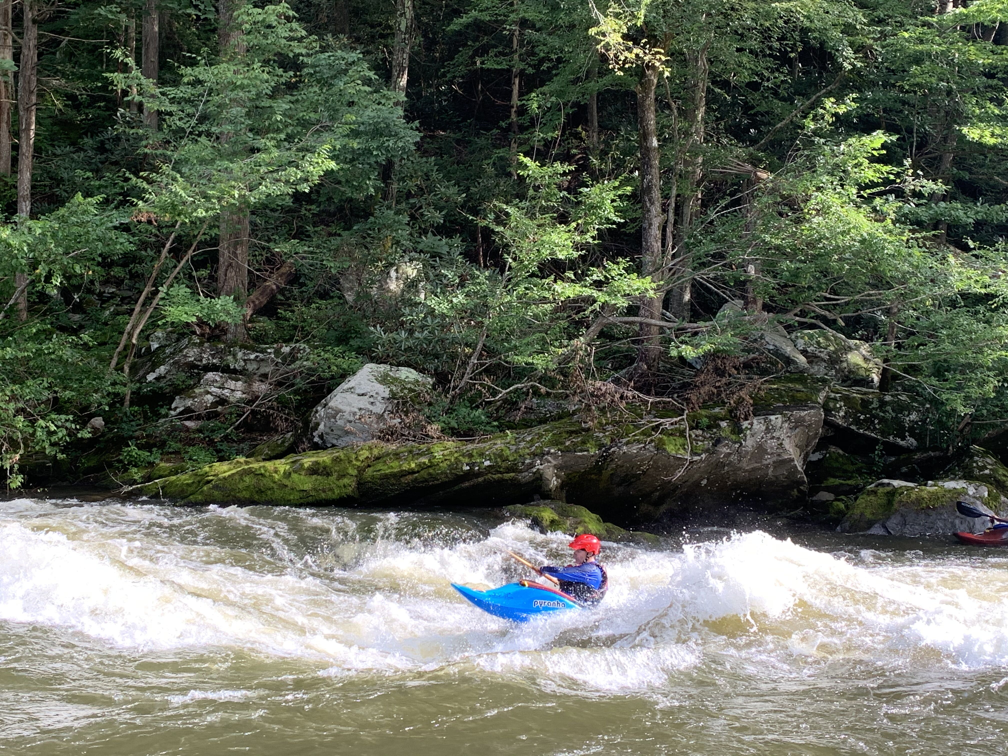
Snap dragon is drastically different, the rapid now has two holes in it and alot of wave train. It is significantly longer now and has alot more play in it. Easily my new favorite rapid! At higher flows (2000+cfs) I've been cutting to the right at the top and finding my way back left at the center to aviod the hole as it becomes pretty nasty.
Roller coaster now has a line with a drop for kayaks on the left, but be careful of the rocks at the bottom for flows under (~1200cfs). The middle line has a nice pourover with a good surf spot, then flows to the right through the bend like before. The big sideways wave is still there but only at flows greater than 1600cfs
A few of the rocks are still there in playground, but showstopper (the surf hole top of playground) is not there anymore and everything after that starts to flatten out. Here is where you really start to see the impact of the flood on the interstate. They have constuction all through here. The water runs to the right next to the rock road they've built for construction.
This is where it gets tricky to know where your're at because all of the rocks have moved and all the rapids are different. Through S-turns you'll see a lot of class 2 bougie water, maybe a small hole here and there. It looks very open and you can see everything. Most of the water flows and stays to the right here.
Guide is completely new, pyramid rock is gone, theres a couple of new holes spread out through it. The left line is there but can be difficult to accomplish, the hole on the left ('the soup') is no longer there either. Through the right line dodge two big holes and ride the wave train. The railroad wall has seen a lot of damage, and the river bed is much higher here than it previously was. The cove behind the wall on the left side after guide is now a mountain of rocks. Sheet metal is creating a bigger zipper rapid with a small wave train now.
Roostertail has flattened out at the top a little, the rapid seems more level with the beach that is to the right of it now. However, the wavetrain at the end can get pretty big and flows for a bit longer than before.
Brown's lake is just about the same, the banks are full with debris. Definitely shallower in most places, the water flows all the way to the left for most of it now. The creek that feeds into the river here had a bunch of silt deposited and blocked it for awhile, but with recent rains and higher water levels its washing the sand away beginning to open it up again.
Duck and run is now 'Dodge or die'! It is imperative that you start angling away from the right bank as soon as possible, there is tons of trees that got pushed up onto the bank and now the water runs straight into and under big piles of them. Stay to the far left and you will be fine. Other than that, it as a new feel to it as well, big wave towards the end in the center of the rapid with a medium wave train after it.
The part of the river after that where you would move in an zig zag fashion is now filled in with rocks all on the left bank. The island that separated the river left and right above duck and run has grown forcing all the water to the right. There are a few waves and pourovers through here.
Rock Garden is now the line to take if you had a full load of people, getting to the microwave line can prove to be quite difficult because of how shallow it is now. Theres plenty of water heading to the right at the top now and you can ferry back to the left at the bottom before basketball rock easily. Microwave has been washed out, theres a few new waves but nothing worth whitewater hiking to get to. The Right side of the river in this area is now higher up than the left, where as before it was the same height bank to bank
Double reaction looks about the same, but its all smaller. The tombstone rock has shifted apart a little, and the curler wave is still ther but significantly flatter. High flows it is a different story though, looks closer to what it was around 2800+cfs. You can now go on the left line of tombstone at normal release flows. (As of 3/11/25, there is a giant tree with a rootball blocking the left line at double).
Superglue is non-existent now, the rocks have all moved and even when the wave is somewhat there, there is a rock at the bottom of it which prevents you from getting in the little bit of surf that is left. There are some nice wave trains that form through here though, it's not what it used to be but its not a bust in my opinion.
Accelerator is a little more steeper but not by much, the biggest change here is being able to run a right then center line or even a left line if you're feeling it. I think the lines have opened up here a bit more than they used to be. When in doubt though, go over the small curler then stay right of center.
Governor's hole isn't much different other than that the right line opened up quite a bit so you don't have to go left here in a raft anymore.
Swimmers stretch now has a rock feature in the middle just before the jump rock. Other than the construction on the right side, it is pretty much the same. The channel leading into the outopost to the left at the end has seen so much rock and tree deposited it looks completly different.
Rock and roll changed substansially due the flood reloacting Johnson's Island. The rapid is now completely flat and doesn't open to the right unless the flow is above 3000cfs. As the flow goes left, a new rapid has formed here and we have been calling it 'Aftermath'. There are two channels on the far left, one cuts to the far left and goes by the Raft Outdoor Adventures outpost and the other cuts right to Aftermath.
There are a few waves headed down to the public takeout, theres a nice surf hole by the road that we call 'road hole' and the big rock right after 'your mom'.
The public takeout got flooded but is still there, the bp was severly flooded and has closed. The town of Hartford saw a lot of water and people are still in the recovery process, remeber to support small business in the area!
***Trip photos taken 2/22/25***