Devils
Baker's Crossing to Rough Canyon Marina (47 miles)
| Difficulty | I-II+(IV) |
| Length | 47.2 mi |
| Avg Gradient | 8 fpm |
| Gauge | Devils River at Bakers Crossing Near Juno |
| Flow Rate as of 1 hour | 4.65 ftmedium runnable |
| Reach Info Last Updated | April 6, 2016 |
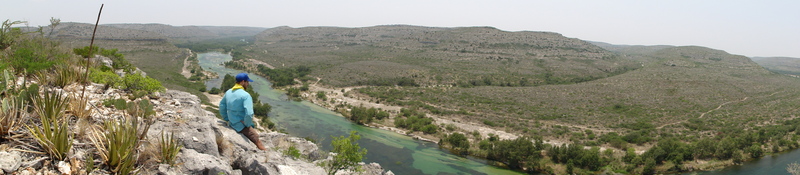
The Devils River is a true desert oasis. Bounded on all sides by arid scrubland, the river's constant spring-fed base flow creates a unique riparian ecosystem with numerous cottonwoods and other large trees, water as clear as a coral reef, and abundant fish and wildlife. The geology of the Devils is unusual, even for Texas. Numerous uplifted limestone slabs create artificial dams, so essentially the river takes the form of a series of long lakes separated by short rapids. The rapids are frequently braided into narrow channels separated by dense vegetation. The physical character of the river thus bears more resemblance to a mountain stream than it does to a typical Texas river. The high calcium content in the water (which is responsible for its clarity), as well as the relatively low flow, has caused accretion of a travertine-like substance on all of the rocks in the shallow areas of the river (i.e. the rapids.) This substance is extremely grippy and rough and makes it impossible to run many of the rapids at low flow. It also puts a great deal of wear & tear on boats. With the exception of the four named rapids (Sycamore Chute, Dolan Falls, Three-Tier, and Dandridge Falls), the rest of the rapids are Class I-II and are often separated by miles of flat water with frequent headwinds. Thus, many choose to paddle the Devils in recreational boats rather than whitewater gear. The appeal of the Devils is mostly its scenic beauty, crystal-clear water, and the experience of overnighting in one of the most remote areas in Texas.
As with many scenic rivers in Texas, the Devils has numerous access issues. TPWD owns two large sections of land, one at approximately Mile 15 (from Baker's Crossing) and another at approximately Mile 30. These are called, respectively, the Del Norte and Dan A. Hughes (formerly Big Satan) Units of the Devils River State Natural Area. Unfortunately, however, as of this writing, only authorized outfitters/guides (concessionair
...
TPWD owns a small piece of land adjacent to the bridge on the downstream river left (northeast) side of the crossing (look for the Devils River SNA sign.) Paddlers are free to access the river here, but there is no long-term/overnight parking or camping allowed. Parking and camping are available 1/4 mile south on Hwy. 163, at Baker's Crossing Camp. Both the locals and the sheriff claim that Baker's Crossing Camp has a high incidence of vehicle vandalism (including removal of wheels), and they advise strongly against leaving an unattended vehicle there. It is unknown how legitimate this risk is. It is possible that the locals are overstating the risk in hopes of discouraging paddlers from running this section of river, or in hopes of encouraging paddlers to use an outfitter. Regardless, it would be ill-advised to leave valuables or a nice car at Baker's Crossing Camp.
If you can catch Mr. Baker, the landowner adjacent to the state-owned put-in, he has been known to let boaters camp and park on his land-- for a price.
The springs that provide most of the base flow for the Devils are about 8 river miles upstream from here (above that point, the river is normally dry), but there is no public access above Baker's Crossing.
Known to be duckable at 2.3'. Will probably require a portage at higher levels.
This large island near the confluence of Miller Canyon is a popular legal (but unofficial) camping spot for paddlers. This can be used the break the trip into more manageable segments. There is a house on the river right bank within shouting distance of the island, so keep a low profile if you camp here.
Must-portage. No public access or camping.
II+/III- at most levels. Requires a slight S-turn in a narrow chute.
This large island near the state natural area boundary is a popular legal (but unofficial) camping spot for paddlers.
Paddler camp on river left, part of the Del Norte Unit of Devil's River State Natural Area. Composting toilet is available. Camping is by permit only (for a nominal fee-- reserve well in advance.)
This is also a potential put-in for those who don't want to run the entire river, but please note that only authorized guides (concessionaires) are allowed to drive to the river access points in Devils River SNA.

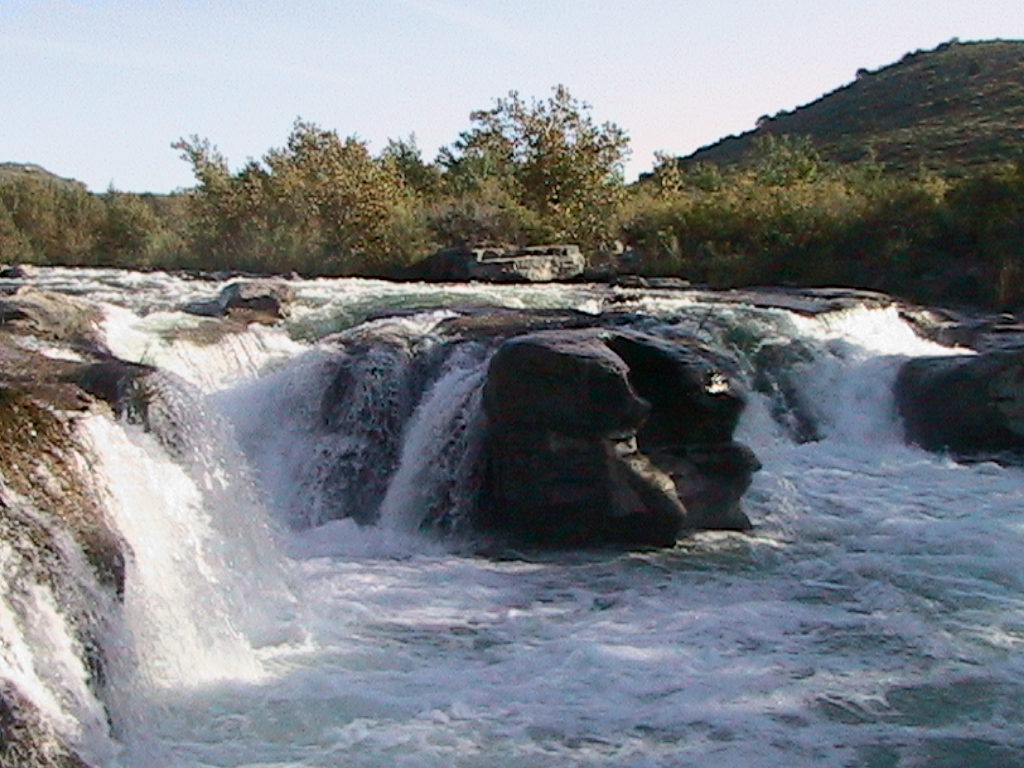
Dolan Falls, supposedly the biggest continuously-flowing waterfall in Texas, is a 12-footer that is known to be runnable (by experienced whitewater boaters with appropriate boats and gear) at 2.3' and higher. The lead-in is likely too shallow at lower levels than that. At very high levels, Texas Whitewater describes 'nasty hydraulics.' Suggested portage for long boats and recreational boats at all levels.
If you choose to run the falls in your whitewater boat, it is strongly recommended that you unload it first. The basic move is to enter from river left into the left-to-right chute above the falls, then take a right boof stroke at the lip of the falls to send you left and away from the hydraulic at the base. At higher water, it is likely that another line opens up to the right, avoiding the meat of the falls. Use extreme caution, however, as there is also a 'room of doom' at the right, which may come into play at high water.
Dolan Falls is owned by the Nature Conservancy, and there is a 24-hour surveillance camera located on the river right bank. In general, the rangers will advise you that running the falls is OK, provided that you have sufficient skill and proper equipment, but hanging out on the banks for any significant length of time is not OK. The rangers seem to believe (incorrectly), and have recounted to boaters, that the only reason why it is legal to portage Dolan Falls is that the state has a cooperative agreement with the Nature Conservancy.
II+/III- at most levels. The first tier requires a slight S-turn and, when the flow is relatively low, it generally can only be run at river right. The other two tiers have straightforward lines, and when the flow is relatively low, they can generally only be run at river left.
The Blue Sage Subdivision runs from approximately Mile 21 to Mile 25. Boaters can access the river here by paying Gerald Bailey (Devils River Outfitters, 830-395-2266.) As of this writing, Devils River Outfitters is not a TPWD concessionaire and cannot give you access to either of the Devils River SNA units.
Paddler camp on river left, part of the Dan A. Hughes (formerly Big Satan) Unit of Devil's River State Natural Area. Composting toilet is available. Camping is by permit only (for a nominal fee-- reserve well in advance.)
This is also a potential takeout for those who don't want to run the entire river, but please note that only authorized guides (concessionaires) are allowed to drive to the river access points in Devils River SNA.
Numerous large islands (AKA legal camping spots) exist between Mile 30 and Mile 32, adjacent to the state natural area.
At least according to Google, the Amistad National Recreation Area starts here. According to the NPS web site, backcountry camping is allowed in the national recreation area (including presumably along the banks of the river), as long as it is at least 1/4 mile from a developed area.
When Lake Amistad is at full pool, the Devils will run out into the lake near here, and arranging a motorboat shuttle for the remaining 14 miles to Rough Canyon Marina is strongly advised. When Lake Amistad is low, then an additional 4-5 miles of shallow rapids can appear below Pafford Crossing.
At low levels, a river-wide (200-yard) breakwater constricts the flow to a smaller channel at river right. It is unknown what the purpose of this structure is (possibly to prevent backflow from the lake into the river.)
Oct 10, 2025
I went with 5 guys and then went back again with 11 guys. This was so picturesque. The water was beautifully hypnotic compared to any other river I've floated. It wasn't easy finding camping on the side of the river because we were scared of trespassing. There are many places where it's important pick the right spot to hit because of how many dead ends there are. The jungle of reeds were definitely difficult to navigate. Both times I brought a 16 ft tandem which I regretted because how much I had to portage.
Jun 1, 2011
This location is about 1 mile before Dolan Falls