Bear
01. Sulphur Campground to Evanston
| Difficulty | I-III |
| Length | 52 mi |
| Avg Gradient | n/a |
| Gauge | Bear River Near Utah-wyoming State Line |
| Flow Rate as of 48 minutes | 100 cfsbelow recommended |
| Reach Info Last Updated | May 14, 2023 |
The Bear River has several different sections that can be run during the spring snowmelt.
The upper Bear River flows North from Utah into Wyoming and flows swiftly with mostly continuous class II whitewater interrupted by a few lower gradient stretches, some fences and the occassional wood hazard.
The runs begin on the Uinta-Wasatch-Cache National Forest. Some of the best whitewater is just downstream of the Forest Service boundary where the river flows through private land with very limited access.
Hayden Fork of the Bear, Sulphur Creek Campground to East Fork Campground, Class 1-3, 12 miles.
Begins slow with meadows and beaver dams but transitions to more continuous gradient as you pass Beaver View Campground and then Hayden Fork Campground. Look out for wood hazards. You pick up additional flow as your pass Stillwater Campground where the Stillwater Fork of the Bear joins the river. Hayden Camp to Stillwater Campground (5 mi) or on to East Fork Camp (another 3.5 mi) are the best whitewater stretches with a legal takeout.
Bear River, East Fork Bear River Campground to USGS Gage, Class II-III, and 4 miles
Some of the best whitewater on these upper reaches of the Bear River with fast continuous rapids. Shortly after you paddle below East Fork Bear River Campground, you cross the Forest Service boundary as the river flows through private land nearly all the way to Evanston. This private property makes finding a take-out an issue and because of that the run is not often done.
USGS Gage to Chalk Creek Road, 11 miles
This section is said to have a number of barbed wire fences across the river, so it is rarely run.
Chalk Creek Road to Highway 150 Bridge, 13 miles
Unknown [no Beta available].
Highway 150 Bridge to Bear River State Park in Evanston, class II, 11.5 miles
Fast, bank-to-bank mostly flatwater, with no rapids of note until getting close to th
...Forest Service Campground on river left that can be used as the start of a run on the Bear River. The campground has 15 single family sites and 5 double family sites that come equipped with picnic tables and fire rings with grills. One group site is available, which accommodates up to 25 people. Vault toilets and garbage service are provided. Water is available, but may be limited. A campground host is located on-site.
Forest Service campground on river left. The campground has 7 single sites and one group site with a capacity for 50 people. Restrooms and drinking water are available.
Access from the campground on river left. This campground has 9 single use sites, a toilet, and drinking water.
Forest Service campground on river right. This campground has 21 single sites, 3 groups sites with capacity for 50 people, 1 group site with capacity for 25 people, and 2 group picnic areas. The campground has toilets and drinking water.
The Forest Service East Fork Campground (7 single sites) is immediately downstream of the confluence with the East Fork of the Bear River on river right. Bear River Campground (4 single sites) is on the upstream side of the confluence. Shortly downstream of this campground you leave Forest Service lands.
Gary Nichols describes this as a preferred take out in the vicinity of the Bear River UT-WY State Line Gage which is near a bridge but also notes that private property limits the ability to use this site as a take-out.
Take out at the bridge within the highway right of way.
Access at the bridge within the highway right of way.
Take out as you are approaching town and enter Bear River State Park or contine on down through the whitewater park described in the next run.
May 29, 2017
May 29, 2017: Paddled from the first bridge on hwy 150 headed S out of Evanston, about 8 miles S of town (mp 12 or so?) at about 1200 cfs. Fast, bank to bank flat mostly water, no rapids of note until getting close to the town play park, no wood that could not be avoided with a little looking ahead, about a half dozen fences that had been pulled down. There were 2 fences across the river - it was possible to go under each on the correct side of the river (first right, 2nd left). They were not hard to see, but both could have been missed until too late if someone were drifting along backwards and not paying close attention, especially the first one as it was just past a very sharp right bend. No 'no trespassing' signs, easy put in at the bridge. Took out at the whitewater play park, 13 miles, something like 3 hours. Lots of wildlife (moose, raptors, waterfowl). Parallels the road but with little or no road access until reaching Evanston. Fun in a fast, consequential class 2ish way. Not sure what the ideal flow window was - 1200 cfs was plenty but higher would be ok and it would probably be good with half that flow.
Jan 3, 2012
Sulphur Camp to Hayden camp has a lot of wood and beaver dams. Hayden camp to Stillwater camp(5 mi) or East Fork camp (another 3.5 mi) would be the best stretches with a legal takeout. Above 1600 cfs is preferred; this usually means peak runoff (and therefore icy cold water). There is a lot of wood avoidance on creeks in the Uintas. East Fork to milepost 51.5 has been popular in the past, but the takeout involves a 1/4 mile hike up a steep hill on private land, and in 2011 there were reports of the landowner having a security guard at the takeout, especially if shuttle cars were parked there. The next legal takeout appears to be the Chalk Creek bridge, which is 10 miles down from MP 51.5. This section is said to have a number of barbed wire fences across the river, so it almost never gets done. Getting permission to take out on private land somewhere below MP51.5 would make the section below East Fork (fun class III wave trains for a few miles) doable again.
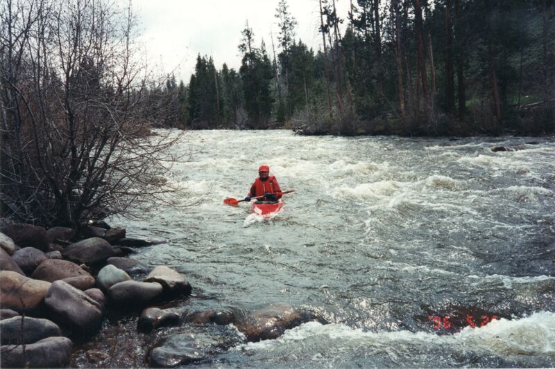
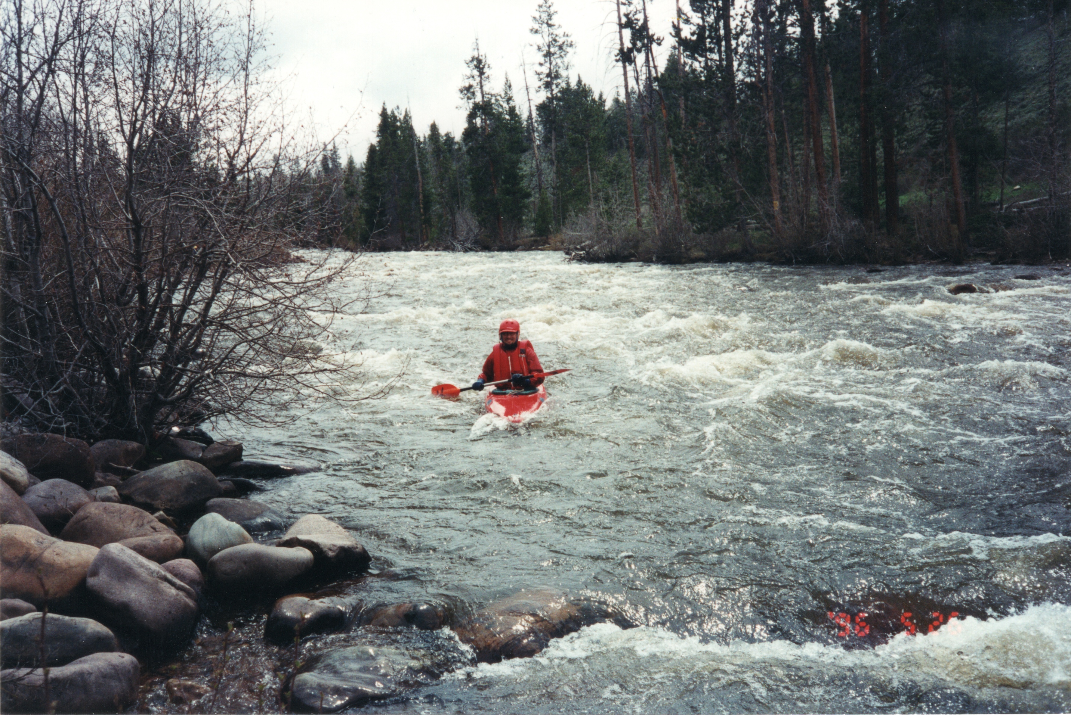
May 26, 1996
Heading back to Wisconsin from Utah, we made a stop to enjoy a quick paddle on the Bear River.