Green
01. Flaming Gorge to Lodore (CO)

| Difficulty | I-II(III) |
| Length | 47.5 mi |
| Avg Gradient | n/a |
| Gauge | Green River Near Greendale, Ut |
| Flow Rate as of 1 hour | 3020 cfsrunnable |
| Reach Info Last Updated | June 25, 2024 |
American Whitewater is working to protect the Green River—one of the West’s most iconic and ecologically significant rivers—from harmful water diversions and to ensure its long-term protection under the Wild and Scenic Rivers Act. Flowing from Wyoming’s high plains through Utah’s canyon country before joining the Colorado River, the [...]Read More
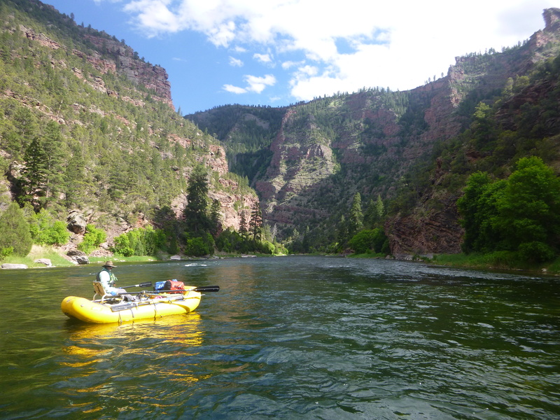
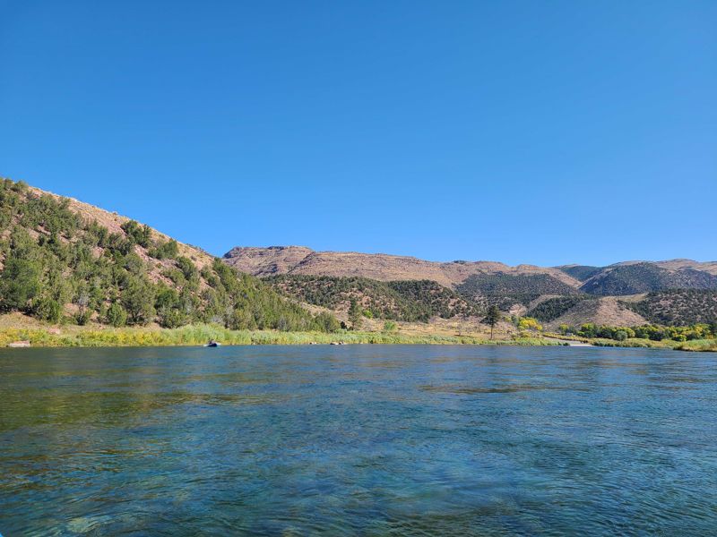
Known as the A, B, and C sections of the Green River this section can be run in parts as day floats or linked together as a casual multiday. Endowed with year-round water suply thanks to the up-river Flaming Gorge Resevoir, these sections can be busy when other rivers are no longer flowing. World class fishing is available throughout the run, along with spectacular bird watching, wildlife and canyon views. With few rapids of note and pleanty of camping, the ABCs are a great late-season fix for river junkies.
Float maps of the rivers sections are available in the gallery.
The Flaming Gorge Resort provides shuttles to the Flaming Gorge Dam put-in and pickups from Little Hole or Indian Crossing as well as raft and ducky rentals. They can also provide transport to and from the airport.
Section A has Class I and II rapids that are perfect for the duckys and takes about two hours to float.
Head south on FR 219 off of hwy 191 between the Flaming Gorge Resevoir and Dutch John Utah. There is a day use kiosk taking payment for use of the boat ramp ajacent to parking and staging areas. The ramp is frequently very busy with commercial fly fishermen and their guests. A long, steep starcase connects the parking area with the launching area.
The Little Hole National Recreation Trail follows the north side of the Green River between Flaming Gorge Dam and Little Hole seven miles down-stream. Hiking and fishing access are the major attractions. Camping, fires, and horses are NOT allowed on this section and mountain biking is NOT allowed Memorial Day to Labor Day weekends.
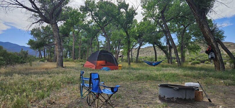
The lower Little Hole Trail extends from Little Hole about two miles downstream. Horses and moun- tain bikes are welcome. Float-in or hike-in camping is allowed only in designated riverside camps.
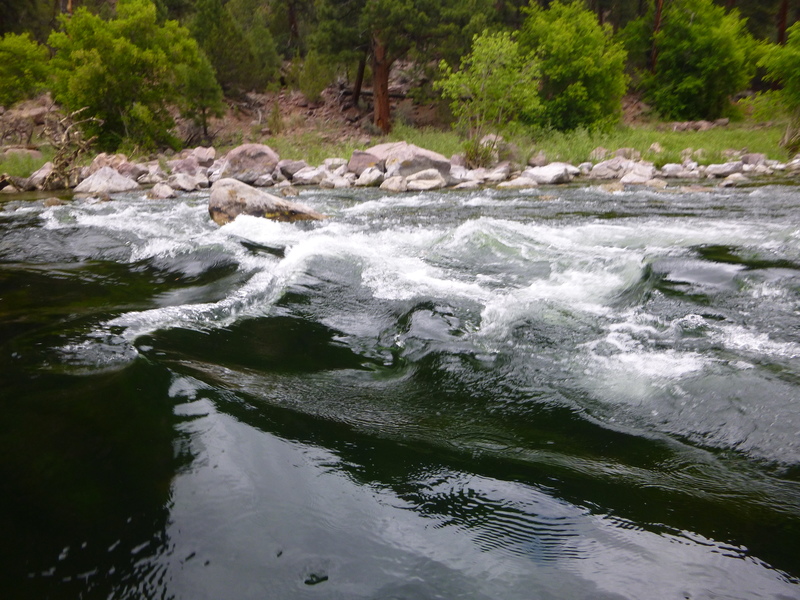
Red Creek Rapid is a class III rapid that can be vary greately depending on the flow of the river. At low flows there are two channels. The majority of the water goes right, with a series of holes towards the top, followed by two large bolders to avoid and a bolder garden in the exit. The left channel is shallower but straighter with a similar boulder garden below.

(BLM) North side (river left) Fee Area. Includes boat ramp, drinking water, toilets, and dump station.
Mile 15.4
Bridge is not passable at flows of 4500 CFS or greater (BLM Map Warning) as water is too high to pass under the bridge. Take out prior to bridge at Indian Crossing Campground or Bridge Hollow Campground.
Located 400 yards downstream from Indian Crossing is the Bridge Hollow Campground (fee area) which offers drinking water, toilets, boat ramps, and a credit card phone.
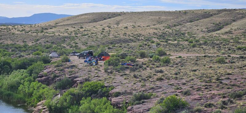
Established campground in Browns Park National Wildlife Refuge with picnic tables, fire rings, and pit toilets. Campsites do not have direct access to the river and only two campsites have shade. No potable water is available. A vehicle is recommended to get from the launch ramp to the campsites for shuttling gear. Overnight parking is not allowed unless camping. Camping is free. Be prepared for misquotes and flies in Browns Park National Wildlife Refuge.
Established campground in Browns Park National Wildlife Refuge with picnic tables, fire rings, and pit toilets. Campsites do not have direct access to the river. All campsites are located in a stand of cottonwood tree's. No potable water is available. A vehicle is recommended to get from the launch ramp to the campsites for shuttling gear. Overnight parking is not allowed unless camping. Camping is free, may have lots of bugs in summer months.
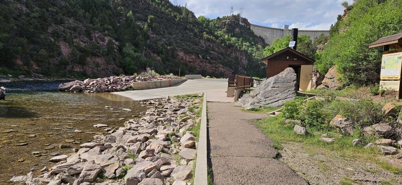
Gates of Lodore launch ramp. Free play permit from Dinosour National Monument required to end at this location
Jun 25, 2024
FloatfromSpillwayLaunchRamptoGatesofLodore in5days(M-F).Flowssub1000andweatherinmid80's.Sectionfromendofthe CtoGatesofLodoreveryflatandrequiredalotofrowingbecauseofwinds.Unlikely, we'dfloatsectioninBrowns ParkNationalWildlifeRefugeagainwithraftsbecauseofveryflatwater,lessthanidealcamping(requiredtocampinestablished campgrounds), and quite a bit more bugs than in the ABC section. However we did not see any other boaters for those two days in Browns Park NWR.
ABC section beautiful and nice camping. Left run of Red Creek Rapid (III) was possible in 16ft rafts, but a lot of sleepers and boulders to dodge in lower part of the rapid.
Jun 16, 2024
We had four packrafts and one 12ft round boat with simple raft set up. We had tail winds (thank god) and great weather. Really fun overnighter with lots of paddling required if doing A and B section in one day. Took us about 8hrs to do sections A and B, and another 4.5hrs to do section C. Headwind can be a serious issue given all the flatwater. Plan on having three or more paddlers on your raft if you have a standard raft set up. Plenty of camping available that doesn't require reservations at Indian Crossing and Bridge Hollow. Most of the BLM camping along the riverside after these established campgrounds were taken and were few and far between so if doing a un-reserved float, plan to camp either at Indian Crossing or Bridge Hollow. Just after Indian Crossing boat ramp there is a subtle manmade eddy area with a footpath that leads to campsights 9 and 10. You can tie up your raft here and MAKE SURE YOU TIE UP YOUR RAFT because the dam release happens every night and water rises 2 to 4 feet every night depending on the dam release quantity and duration. Ground here is packed roadbase/gravel so staking is hard. Mosquitos were definitely around in mid-June so beware. They were the worst at Swallow Canyon Road take-out. The breeze kept them at bay at Indian Crossing. Bring deet. Wonderful wildlife. SOOO many dory guided fishing boat tours. We were one of maybe 3 rafting parties just there to float and not fish out of the 50+ boats we saw on the water that day. Lunch at Little Hole had picnick tables and trash bins and bathrooms. A good halfway point for your A+B float. We ran the Class III section twice in our packrafts. We did the easier left side and the harder right side. Both awesome and fun and definitely required a scout beforehand. This river is for the fisher-people and not for the whitewater folks so they really slow the flows down for the fishing. This makes the Red Creek Class III rapid really bony and honestly quite easy. You just need to scout a couple rock avoidances on the left. The right side had some holes to stay left on and stay away from the churning water on the right cliff wall. Spits you out fine and don't forget to avoid the rocks after the fun parts.
Great weekend!
Jun 19, 2023
Super scenic! Had a great time on the river this weekend. A couple things:
If you are running the A section from Spillway boat launch and want to use a an oar rig, you pretty much need access to a trailer. There are signs that you cannot inflate anywhere near the water (and people there to enforce that), and the parking area where they suggest you inflate is a quarter to half mile from the water. I rented a trailer in Dutch John - would have liked to know this ahead of time.
There are a couple unnamed/unmarked rapid sections before Mother-in-Law at ~800 cfs, class II maybe? nothing hard or techical, but if you are expecting totally-flat to riffles this was a little more than that