Icicle Creek
1 - Rock Island Campground to Johnny Creek (Upper Upper)

| Difficulty | II-III+(V) |
| Length | 5.5 mi |
| Avg Gradient | 60 fpm |
| Gauge | Icicle Creek Above Snow Creek Near Leavenworth, Wa |
| Flow Rate as of 1 hour | 236 cfsbelow recommended |
| Reach Info Last Updated | May 30, 2026 |
The Okanogan and Wenatchee National Forests encompass more than four million acres and are jointly managed with headquarters in Wenatchee, Washington. The rivers flowing through these forests are essential to the whitewater paddling community—both as close-to-home runs for Washington residents and as classic objectives for paddlers traveling from across [...]Read More
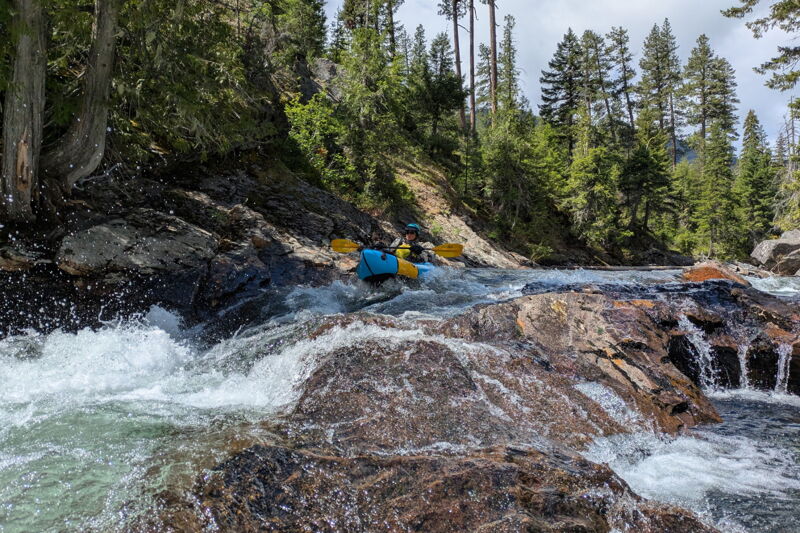
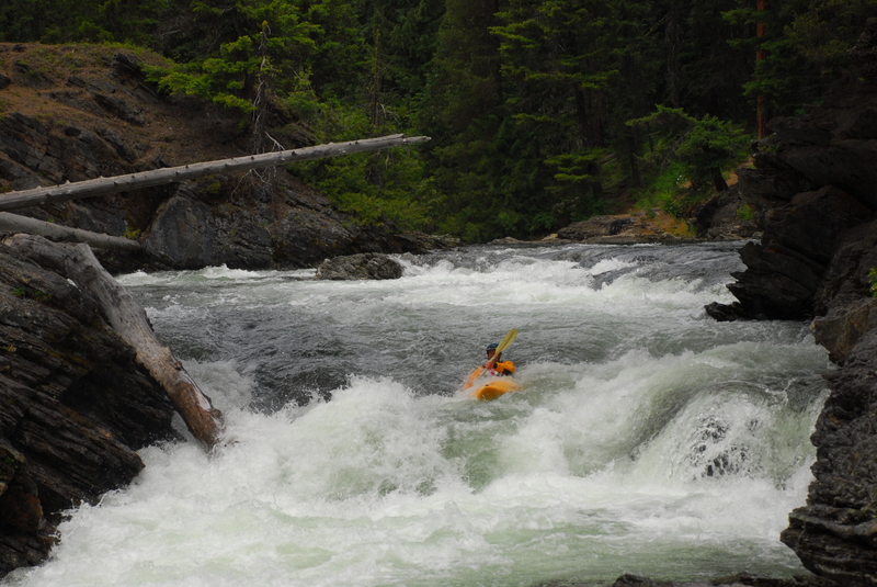
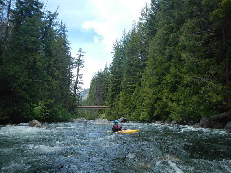
The upper upper reach of Icicle Creek has some fun whitewater but the personality of this run is hard to pin down: a class II braided mess, class V hair, or delightful class III? This run has a little bit of everything. The run starts off with a fun class IV drop at Rock Island. Put-in upstream of the bridge and run the drop under the bridge to the delight of spectators who hike the Icicle Gorge Trail, camp at Rock Island, or enjoy the day-use area on the downstream river left side of the bridge. Continuing downstream, the river is fairly continuous class II with fun stretches of class III. Expect to find wood in play and remember that the water is always cold--they call this Icicle Creek for a reason. You will recognize the approach to Icicle Gorge as the river takes a hard bend to the left at a big bedrock wall that extends down to the river along river right and forms a fun rapid. As the river makes another hard bend to the right you will be looking downstream into Icicle Gorge--you should see the footbridge that crosses the river. Icicle Gorge can be easily scouted before the run as a trail parallels both sides of the river and a bridge crosses the heart of the gorge just above the crux move--a class V drop with a massive boiling hole. To portage this, you can run the first class IV entrance drop into the gorge and then grab an eddy on river right that provides easy access to the riverside trail. Shoulder your boat and hike down to the footbridge, cross to river left, and hike up the short switchback trail to the road. You can put-in by hiking a couple hundred hards to the Chatter Creek Guard Station. A social trail behind the toilet heads down towards the river but kind of disappears before you reach the river (keep angling upstream). If you don't want to deal with the poor footing, you can just continue down the road about 1/4 mile to where the river comes up against the road. Downstream of Icicle Gorge, the river is mostly class II with the occasional shor
...From Highway 2 mile 99.1 (the west end of Leavenworth) turn on to Icicle Creek Road. The Rock Island put-in is reached 16.5 miles up Icicle Creek Road where you turn left at the Y and continue another 0.1 mile to the bridge across Icicle Creek. To run this first drop, access the river on the upstream river left side of the bridge.
A fun rapid under the bridge that starts off the run. You can run it or put in just below.
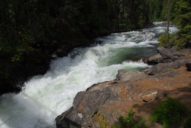
A short class V gorge that can be easily portaged. You can view the Icicle Gorge 15.0 miles up Icicle Creek Road immediately across from Chatter Creek Campground. You should see the foot bridge across the gorge if you look down towards the river and there is a short switch back trail here that takes you from the road down to the trail along the river.
From Highway 2 mile 99.1 (the west end of Leavenworth) turn on to Icicle Creek Road. The Ida Creek Campground 12.6 miles up Icicle Creek Road has served as a take-out for this run but it can also be a put-in for a short mile and a half run down to Johnny Creek (good for an evening lap when you are spending your days on the Wenatchee but camping along Icicle Creek).
From Highway 2 mile 99.1 (the west end of Leavenworth) turn on to Icicle Creek Road. The Forest Road 7605 Bridge is located 12.2 miles up Icicle Creek Road. This access avoids the final mile of continuous class III+. Alternatively you can use this as a put-in if you are looking for a short run.
From Highway 2 mile 99.1 (the west end of Leavenworth) turn on to Icicle Creek Road. Johnny Creek Campground is located at mile 11.2 on Icicle Creek Road. Several sites in the campground provide convenient river access but if they are all full, you can find a good access at a mini beach between sites 5 and 6 that avoids walking through someone's campsite. The creek quickly builds to class IV downstream of this access point.
Jun 9, 2026
Ariel and I had a delightful day paddling Upper Upper Icicle Creek. The long boulder gardens at low flow made for an almost meditative experience as we were busy finding a clear path through. When we weren't looking for our line, we were enjoying all the granite mountain views. — It was 620 cfs (icicle abv snow lake) on a sunny Sunday, 6/9/26. We put on at Rock Island cg and took out at Johnny Creek cg. The run was pretty clean of wood aside from a small log jam blocking most of the channel at the bottom of a boulder garden. We snuck it to the right. — Flows were low, but the run was still enjoyable. We were always able to find a channel with enough water that we never had to get out of our boats and drag. The bedrock drops were getting a bit scrapy, and the boulder gardens a little bumpy. Fun nonetheless. I wouldn't want to go lower, but could probably see going as low as 500cfs. I'm guessing 700-1000 would be the easiest flow. I'd probably like to see it between 1000 and 1500 next. — We scouted icicle gorge (V) on our way to the put in to identify our exit point for the portage. The hiking trail that crosses and hugs the river is quite beautiful! — Rock Island was fun but a bit low. Decided to tackle the left channel as the right looked a bit squeezy at these flows. The little entrance ledge drop caught hold off my packraft and sent me down a bit askew. Had to throw a rocky brace to avoid swimming the rest of the shallow steep rapid. After that it was smooth sailing down to a fun little 4’ drop. Good times! Ran it again to see if I could clean up my line but the outcome was about the same. Looking forward to coming back here with a bit more water. Put in: (47.60784, -120.91715) — Shortly after leaving the campground and its spectators behind, I was delighted to enter the little gorge with some fun little bedrock rapids. Beautiful little section of river. From there on there was some fun easy class III boulder gardens. At the bottom of one was the only real wood in play for the day. Snuck it to the right. Wood: (47.61027, -120.90628) — More little boulder gardens followed. Saw a few harlequin ducks! There were also some calm meandering stretches with scenic mountain views. — Before we knew it, we arrived to the III+ headwall rapid we had hiked to during our portage scout. It was one of the best rapids on the run! The river bounces off the cliff face and pours over a few boulders. It can be scouted or portaged via a river left cobble bar. You could probably even hike up the hill to the river left trail if you wanted to start your icicle gorge (V) portage from there. Cobble bar scout: (47.60598, -120.88985) — After running the headwall rapid there was a 30 yard recovery stretch before our river right portage eddy. It was 10 yards above another drop that leads in to continuous class IV- before the class V drop. Portage Eddy: (47.60652, -120.88892) — The hike alongside the river is short and beautiful. When we got to the bridge we gawked at the river wide frothy ledge hole below. Hiked up to the road, downstream to the pit toilet, and followed the social trail to the river below. Maybe a 10 minute walk? Not bad. Portage Put in: (47.60659, -120.88444) — For the next couple miles the river mellowed and the views really opened up! Beautiful floating. A bit after Ida Creek Campground the river really picked up place. The boulder gardens felt longer and steeper than in the upper section. I agree with the write up that I could see it pushing class IV at certain flows. At 620 it still felt very friendly and playful to me. After a particularly boney, final boulder bar drop, we arrived to Johnny creek campground and find a nice place to tear tear down the boats. Take out: (47.59734, -120.81806) — I biked shuttle. The first couple miles were delightful - paved road and great views. The next few miles, were, meh. The pavement transitioned to washboard gravel, and there was a surprising amount of car traffic on the road kicking up dust. Would prefer to drive or run shuttle next time, but it worked just fine — All in all a great paddle. It was a fun way to mix it up from some surf runs on the Wenatchee! Hit up Dan's afterwards for some sandwiches and picnic’d by the river. Good times.
Jun 16, 2014
Although future landslides are always a possibility, the road is open as of spring 2014. One big log early in the run that may require a portage depending on flows. We also encountered a big braided mess with a few log jams that had to be portaged downstream of Icicle Gorge.