Pilchuck River
1-Road P-500 above Boulder Creek to Menzel Lake Road Bridge
| Difficulty | III+(IV) |
| Length | 6.5 mi |
| Avg Gradient | n/a |
| Gauge | Pilchuck River Near Snohomish, Wa |
| Flow Rate as of 40 minutes | 81 cfsbelow recommended |
| Reach Info Last Updated | December 9, 2024 |
The Pilchuck River (a Snohomish tributary), not to be confused with more popular Pilchuck Creek (a Stilliguamish tributary) to the north, can be a bit of a mixed bag: the put-in road is closed to vehicles so it requires a walk in; most class IV paddlers will wish there were more and tentative class III paddlers will find the canyon to be a little much. Despite these shortcomings, it's a beautiful river and the run makes a good adventure when you're looking to do something different. Although good intermediate paddlers (class III/IV) should be able to handle this run, just be aware of log hazards that can increase the danger factor and occur anywhere along the run.
From Boulder Creek the river pounds through class III- boulder gardens and cobble bars. While this section might be fun at the higher range of flows, it can get a little boney and you'll probably find some wood to portage. The gradient is consistent but there are no good breaks creating defined rapids.
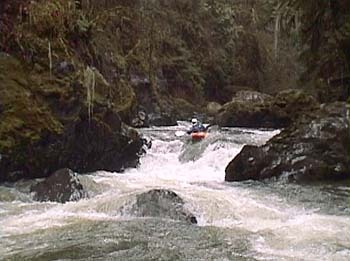
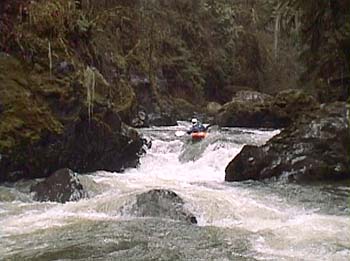
A short distance below the confluence with Kelly Creek the river cuts through a beautiful bedrock gorge. The rapids in this canyon section are all too short, but are the highlight of the run. The first rapid is a maze of medium-size boulders requiring class IV moves to negotiate. At the lower range of flows (900 cfs is about the limit on this one) there are a couple good options for working your way through and at the higher range of flows the slots become wider. The river takes a short pause and then cuts a course through an even longer class IV rapid. After a sequence of two ledges and after negotiating several smaller boulders the river winds around the right side of a large mid-stream boulder and then hops over two more fun ledges. Stay alert for wood and what could be a nasty sieve on river left at some levels. A short distance after this lower rapid the canyon begins to open up and you'll see the road high above.
From here the river meanders back and forth across the valley floor a
...Apr 16, 2021
The dam was removed in August 2020! You can watch it being removed and how the river has repaired itself here: https://www.senserasystems.com/public/embed/M26801545276
Mar 3, 2017
Ran on 3/3/2017. ATVs can no longer get up this old road due to washouts. The first one is just over a mile in. So if you are running this run, you are hiking in. Nick Borelli and Steve Munk hiked in with Pack boats...flow about 1200 cfs and rising. The dam is a deathtrap...don't even think about it. Easy portage left.
Apr 8, 2001
Omar Jepperson, Russ Reed, and Thomas O'Keefe hiked in using carts for our boats. A number of ATV enthusiasts were out on the road too. We found one very cool canyon but it was short and took a lot of effort to get there. We portaged the dam on river left. Image from digital video footage.