Skykomish, N. Fork
1. Jackson Wilderness to Bear Creek
| Difficulty | II-V |
| Length | 7.6 mi |
| Avg Gradient | 125 fpm |
| Gauge | Nf Skykomish R at Galena |
| Flow Rate as of 35 minutes | 2.32 ftbelow recommended |
| Reach Info Last Updated | July 9, 2004 |
ACCESS: From Highway 2 mile 35.6 turn north up the North Fork
Road (becomes FR 63) at the Mt. Index Cafe. You'll pass a turn-off for
Forest Road 6330 at mile 9.1 that crosses the river (staff gauge on river
left side of bridge center pillar). Continue on FR 63, 0.5 miles past the
Troublesome Creek Bridge to mile 11.7 which marks the access point at
Drumbeater where the lower run starts. From this point continue up to
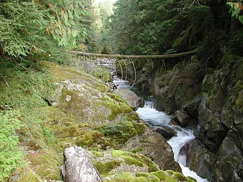
mile 12.3 and a pullout with a short trail down to Bear Creek Falls. Here
the river carves through an impressive bedrock slot with several ledges
over a span of approximately 100 yards. Continue on to mile 14.8 and the
junction of FR 63 and 65. To stay along the North Fork turn up the hill to
the left to stay on FR 63. At mile 16.8 FR 63 ends and you'll want to follow
FR 6300. At mile 18.5 you'll come to a decent overlook that provides you
with a view of the river, and at mile 19.2 you will be at the end of the
maintained road and several trailheads for the wilderness areas in the
basin. Check road conditions with Mt. Baker - Snoqulamie National
Forest; follow link to the forest road conditions report under the
recreation link.
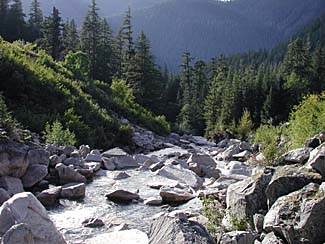
DESCRIPTION: The Upper North Fork is less frequently boated than
the more popular North Fork run downstream. It is characterized by some
big drops and imposing boulder gardens interspersed with several class
II sections.
The river continues downstream on the more popular North Fork
Skykomish run.
Sep 22, 2010
The road from Index up the N Fork mentioned in this description was destroyed by storms and flooding two years ago. No signs or reports of it being rebuilt.
Jul 4, 2004
Bear Creek Falls gets pretty rough at high flows, and becomes completely unrunable when the river at Index falls below ~700 cfs, due to piton rocks and potholes. Between Goblin Creek and Bear Creek Falls, the river is mostly Class II - III. Between Quartz Creek and Goblin Creek, the river drops down a spectacular gorge in almost constant Class V-VI whitewater, culminating in 90 foot Deer Falls (which can be seen by bushwhacking to the gorge rim at mile marker 18 on FR 63). Below the falls, the gorge extends for another 500 feet, with a few smaller ledges throughout, then ends just upstream from the mouth of Goblin Creek, where the river flows into the wider valley below.
Jan 1, 1900
Video footage from the Twitch
series, featuring runs from
Washington and around the world.
Available through the [books & videos link](http://
www.americanwhitewater.org/library/
).