Trip Reports
Log in to add a reportTO
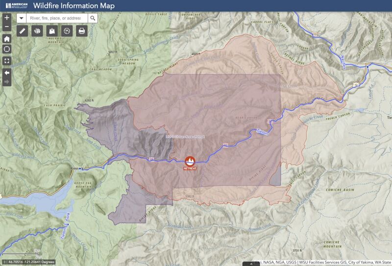
Wildfire Closure - Retreat Fire - Thomas O'Keefe
Aug 20, 2024
As a result of the Retreat Fire the Forest Service has instituted Closure Number 06-17-08-24-22 that encompasses 81,391 acres along the Tieton River from Tieton Road that includes the put-in for this run. This closure effectively prevents access to the Tieton River and will likely extend through the 2024 Tieton whitewater season during draw down of Rimrock Reservoir. This Order is effective August 20, 2024, through October 31, 2024, unless rescinded sooner.
In May 2022 the Regional Forester issued a Leader's Intent letter directing the Regional Leadership Team to 'reduce extended wildfire closures.' American Whitewater is engaged in policy discussions at the regional and national level to ensure that risk mitigation measures other than closures are fully evaluated.
Interactive map of the wildfire perimeter and closure area can be found at this web link: < https://arcg.is/1OKDmS0 >.
DM
Not a place for beginners - Derek Meek
Sep 11, 2022
This is a fun section, but it is not remotely beginner friendly. Girlfriend and I bit off more than I can chew and I almost literally lost my shit. My boat got away and went down to naches and over the dam - fortunately snagged on a gravel bar and some dudes rescued it.
Also at 1950cfs it's almost certainly III+ according to my gf.
BI
Bob Inouye
Aug 22, 2018
August 22nd 2018.
725 CFS.
We ran about 3 miles of the Tieton River, from the access point at River Mile 5 (good place to leave a car), down to River Mile 2 where there’s an easy left takeout just before the foot bridge that spans the river and across from the Oak Creek Wildlife Recreation Area Headquarters.
The water is low at 725 CFS. In a one-seat Outlaw IK, the good maneuverability is an asset. Several sets of boulders sticking part way out of the water, close together is some stretches and needing paddle work to wend through.
About 3/4 mile before the end is the most challenging boulder segment. The fellow I ran with was in a one seat Sun Dolphin sit-on kayak; he overturned in this segment. The Sun Dophin had less maneuverability, in part due to having somehow absorbed a fair amount of water/weight inside the shell.
The bottom of my IK has more rub marks than before, but nothing serious. I only hung up a few times in low spots, which could have been avoided by paying less attention to the camera and more to the river. Total weight load in the IK, including equipment, was about 175 pounds.
Air quality was low today (about 55 ug/m3 of PM2.5 = “Unhealthy” per WA DOE) due to the forest fire up on White Pass. But for up here, for this week, it was a relatively good few hours of air quality.
In summary, a relatively easy run in an IK, lots of maneuvering to do, no hidden dangers or concerning challenges, you’re moving right along. It was good to get some water time, but I’m really looking forward to running it when there’s more like 1,500 cfs.
46.71662 -120.85975: put in
46.71779 -120.81693: Sun Dolphin kayak overturned in boulders
46.72585 -120.81190: take out
WGS84
KH
Karen Hensley
Oct 2, 2006
This lower section was a ton of fun when we did it twice at 1500 in 2006. The book seems to imply that there is much more wood that we saw. The river moves so fast, with so few eddies, that it is extra important to watch for sweepers and strainers, but we didn't see very many. Several of the rafting companies go a fair ways down the lower stretch, and Wildwater River Tours goes the whole way to Tim's Pond river access area. All of the commercial guides on this river are very friendly and helpful in my experience, so you could ask one of them about new obstacles.
You can also put in at Waffle Wall to extend the trip, but skip the weir and some of the longer hairy Class III channels.
Waffle Wall is the first dirt turnoff on the right going downriver from Rimrock Retreat, at about Mile Marker 173.5. If you get to the 'town' (cluster of buildings) at Marker 172.9, then head East, that is the easiest way to find it.
You can take out at Tim's Pond, mile marker 184.5 (+/-). This point is a little over one half mile upstream from the confluence with the Naches. The most signficant rapid is called Surprise because it sneaks up on you. After miles of continuous Class II, with intermittent bigger rapids, we dud not realize we were in the middle of it until we started running out of ways to easily dodge the holes.
It's a very pretty stretch, with some time for checking out the unusually tall columnar basalt, and to look for rock climbers and mountain goats.
A couple more notes: The water is warm. You will need a river access pass to park at Tim's Pond. The take-out at Tim's Pond is a little hidden, it is at the down stream end of the pond, and you can see where rafts have been dragging up the banks. If you run from lake clear to Tim's Pond, as we did, it is 17 miles. It is fast miles, but you have to pay attention the whole way.
DE
David Elliott
Oct 10, 2002
This stretch doesn't see nearly as many boaters as the upper stretch, but if you're coming from the Seattle area, it's worth extending the upper run with the lower. Or, if you're like me and you prefer not having to wait in line to run rapids, this run can be a nice alternative to the crowded upper section.
The best rapid on this section comes at the end of the recently-burned section, about 3 miles from the confluence with the Naches. The rapid is a long (1/2-mile?) continuous boulder garden that at over 2000cfs is full of big holes and waves. In a kayak, this section is a blast.